Country:
 Norway
Region:
City:
Latitude and Longitude:
Time Zone:
Postal Code:
IP information under different IP Channel
ip-api
Country
Region
City
ASN
Time Zone
ISP
Blacklist
Proxy
Latitude
Longitude
Postal
Route
IPinfo
Country
Region
City
ASN
Time Zone
ISP
Blacklist
Proxy
Latitude
Longitude
Postal
Route
MaxMind
Country
Region
City
ASN
Time Zone
ISP
Blacklist
Proxy
Latitude
Longitude
Postal
Route
Luminati
Country
NORegion
11
City
bryne
ASN
Time Zone
Europe/Oslo
ISP
Telia Norge AS
Latitude
Longitude
Postal
db-ip
Country
Region
City
ASN
Time Zone
ISP
Blacklist
Proxy
Latitude
Longitude
Postal
Route
ipdata
Country
Region
City
ASN
Time Zone
ISP
Blacklist
Proxy
Latitude
Longitude
Postal
Route
Popular places and events near this IP address

Bryne
Town in Western Norway, Norway
Distance: Approx. 816 meters
Latitude and longitude: 58.7354,5.6477
Bryne (Norwegian pronunciation: [ˈbrỳːnə] ) is a town in Time municipality in Rogaland county, Norway. The town is the administrative centre of the municipality of Time and it is also one of the 50 largest towns/cities in Norway. Bryne's location in the region of Stavanger/Sandnes and its road and rail links have made Bryne a popular area for commuters.

Klepp stasjon
Village in Western Norway, Norway
Distance: Approx. 3889 meters
Latitude and longitude: 58.77277778,5.67722222
Klepp Stasjon is a village in Klepp municipality in Rogaland county, Norway, on the lakeshore of Frøylandsvatnet, about 3 kilometres (1.9 mi) east of the village of Kleppe and 2 kilometres (1.2 mi) southwest of Orstad. It is named after the Klepp railway station on the Jæren Line. When the line was constructed in 1878, Kleppe was somewhat offset from its path, so the station serving it was placed east of the village rather than in it.

Frøylandsvatnet
Lake in Time, Norway
Distance: Approx. 1504 meters
Latitude and longitude: 58.74972222,5.67583333
Frøylandsvatnet is a lake in Rogaland county, Norway. The 4.83-square-kilometre (1.86 sq mi) lake is located in the district of Jæren. It forms part of the municipal boundary line between Klepp and Time.
Ranglerock Festival
Annual music festival in Norway
Distance: Approx. 1071 meters
Latitude and longitude: 58.7365,5.6421
The Ranglerock Festival is an annual rock festival that takes place in the small town of Bryne, located on the west coast of Norway. Usually arranged at the end of July. The festival was first held at Hognestad in 2002, then being called the Hoggstock Festival.

Bryne Stadion
Football stadium in Bryne, Norway
Distance: Approx. 1186 meters
Latitude and longitude: 58.72976667,5.64977222
Bryne Stadion is a multi-purpose stadium in Bryne, Norway. It is currently used mostly for football matches, and is the home ground of Bryne FK. The record attendance was set in 1980, when 13,621 spectators attended a match against Viking FK. Today, the seated capacity is 2,507, while the total capacity is 4,000.
Klepp Station
Railway station in Klepp, Norway
Distance: Approx. 3920 meters
Latitude and longitude: 58.77277778,5.67916667
Klepp Station (Norwegian: Klepp stasjon) is a railway station in the municipality of Klepp in Rogaland county, Norway. The station is located in the village of Klepp stasjon, about 3 kilometres (1.9 mi) east of the municipal centre of Kleppe. The station on the Sørlandet Line.

Bryne Station
Railway station in Time, Norway
Distance: Approx. 846 meters
Latitude and longitude: 58.73388889,5.64916667
Bryne Station (Norwegian: Bryne stasjon) is a railway station in the town of Bryne in Rogaland county, Norway. The station is located along the Sørlandet Line and it is served by the Jæren Commuter Rail between Stavanger and Egersund as well as regional trains between Stavanger and Kristiansand. The station is located 29.58 kilometres (18.38 mi) south of the city of Stavanger.
Forum Jæren
Distance: Approx. 801 meters
Latitude and longitude: 58.73405,5.64993333
Forum Jæren is a 65,5 meters (67,7 meters at the very top) high skyscraper in the city of Bryne, Norway. The tower has 20 floors and contains offices, meeting rooms, and restaurants. The base area of the tower is 400 square meters.

Garborg Centre
Distance: Approx. 794 meters
Latitude and longitude: 58.7338,5.6506
The Garborg Centre (Norwegian: Nasjonalt Garborgsenter) is an educational centre dedicated to the husband and wife authors, Arne Garborg and Hulda Garborg. It is situated near Arne Garborg's childhood home in the town of Bryne, Time municipality, in Rogaland, Norway. The centre aims to encourage people’s interest for the ideas and visions of the two important authors and members of society in Norwegian history.
Norwegian University College for Agriculture and Rural Development
School in Bryne, Stavanger, Norway
Distance: Approx. 672 meters
Latitude and longitude: 58.7364,5.6495
The Norwegian University College for Agriculture and Rural Development (Høgskulen for landbruk og bygdeutvikling (HLB)) is a small private university college in Bryne, Jæren, south of Stavanger, Norway. The rector is a rural anthropologist, Prof. Dag Jørund Lønning.
Time Church
Church in Rogaland, Norway
Distance: Approx. 2493 meters
Latitude and longitude: 58.7263767,5.695644
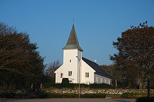
Time Church (Norwegian: Time kyrkje) is a parish church of the Church of Norway in Time Municipality in Rogaland county, Norway. It is located in the village of Time, just a short distance east of the town of Bryne. It is the church for the Time parish which is part of the Jæren prosti (deanery) in the Diocese of Stavanger.
Bryne Church
Church in Rogaland, Norway
Distance: Approx. 904 meters
Latitude and longitude: 58.737247,5.644728
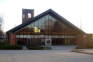
Bryne Church (Norwegian: Bryne kyrkje) is a parish church of the Church of Norway in Time Municipality in Rogaland county, Norway. It is located in the town of Bryne. It is the church for the Bryne parish which is part of the Jæren prosti (deanery) in the Diocese of Stavanger.
Weather in this IP's area
light intensity drizzle
14 Celsius
14 Celsius
14 Celsius
15 Celsius
1011 hPa
92 %
1011 hPa
1007 hPa
2500 meters
4.12 m/s
170 degree
100 %
08:23:46
18:20:26