Country:
 Iceland
Region:
City:
Latitude and Longitude:
Time Zone:
Postal Code:
IP information under different IP Channel
ip-api
Country
Region
City
ASN
Time Zone
ISP
Blacklist
Proxy
Latitude
Longitude
Postal
Route
IPinfo
Country
Region
City
ASN
Time Zone
ISP
Blacklist
Proxy
Latitude
Longitude
Postal
Route
MaxMind
Country
Region
City
ASN
Time Zone
ISP
Blacklist
Proxy
Latitude
Longitude
Postal
Route
Luminati
Country
ISRegion
1
City
reykjavik
ASN
Time Zone
Atlantic/Reykjavik
ISP
Ljosleidarinn ehf
Latitude
Longitude
Postal
db-ip
Country
Region
City
ASN
Time Zone
ISP
Blacklist
Proxy
Latitude
Longitude
Postal
Route
ipdata
Country
Region
City
ASN
Time Zone
ISP
Blacklist
Proxy
Latitude
Longitude
Postal
Route
Popular places and events near this IP address
Menntaskólinn Hraðbraut
Private school in Reykjavík, Iceland
Distance: Approx. 2047 meters
Latitude and longitude: 64.12888889,-21.86694444
Menntaskólinn Hraðbraut (or Hraðbraut; meaning in Icelandic: speedway) was a privately run Icelandic secondary school that ran from 2003 to 2012. The school awarded a student degree after two years of study instead of the then standard four; the school's name reflected this express course.

Elliðaár
Distance: Approx. 844 meters
Latitude and longitude: 64.12166667,-21.84083333
The river Elliðaár (Icelandic pronunciation: [ˈɛtlɪːðaˌauːr̥], "Elliði's river") is situated in the Reykjavík area in the south-west of Iceland. Two small rivers have their source in the volcanic mountain range of Bláfjöll and stream down to Elliðavatn lake at the eastern suburban border of the city, its outlet forming the river. On their way, they pass through the nature reserve area of Heiðmörk.

Árbæjarsafn
Distance: Approx. 1362 meters
Latitude and longitude: 64.11888889,-21.81611111
Árbæjarsafn (Icelandic pronunciation: [ˈaurˌpaiːjarˌsapn̥]) is the historical museum of the city of Reykjavík as well as an open-air museum and a regional museum. Its purpose is to give the public an insight into the living conditions, work and recreational activities of the people of Reykjavík in earlier times.
Hvassaleiti
Distance: Approx. 2015 meters
Latitude and longitude: 64.125,-21.875
Hvassaleiti (Icelandic pronunciation: [ˈkʰvassaˌleiːtɪ]) is a neighbourhood in Reykjavík, the capital of Iceland (103, Reykjavík). Children there used to go to two schools Hvassaleitisskóli (founded in 1966) or Álftamýraskóli (founded in 1964). After their merger children attend Háaleitisskóli.

Árbær
District in Reykjavík, Iceland
Distance: Approx. 1240 meters
Latitude and longitude: 64.118,-21.818
Árbær (Icelandic pronunciation: [ˈaurˌpaiːr̥]) is a district within the city of Reykjavík, Iceland. It includes five neighbourhoods: Árbær proper, Ártúnsholt [ˈaurˌtʰunsˌhɔl̥t], Norðlingaholt [ˈnɔ(r)tliŋkaˌhɔlt̥], Selás [ˈsɛːlˌauːs] and the industrial area Hálsar [ˈhaulsar̥]. The area has approximately 11.974 inhabitants in 2023.
Breiðholt
District in Reykjavík, Iceland
Distance: Approx. 847 meters
Latitude and longitude: 64.10777778,-21.83222222
Breiðholt (Icelandic pronunciation: [ˈpreiðˌhɔl̥t]) is a southeastern district of Reykjavík, Iceland. It includes three neighbourhoods: Neðra-Breiðholt [ˈnɛðra-ˌpreiðˌhɔl̥t] (Bakkar [ˈpahkar̥], Mjódd [ˈmjoutː] and Stekkir [ˈstɛhcɪr̥]), Efra-Breiðholt [ˈɛvra-ˌpreiðˌhɔl̥t] (Hólar [ˈhouːlar̥], Berg [ˈpɛrk] and Fell [ˈfɛtl̥]) and Seljahverfi [ˈsɛljaˌkʰvɛrvɪ] (Sel [ˈsɛːl̥]). It is one of the largest districts in Reykjavík, with a population of around 20,000.
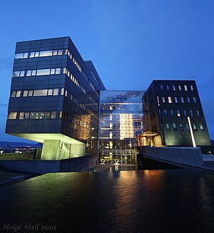
Orkuveita Reykjavíkur
Icelandic energy and utility company
Distance: Approx. 2098 meters
Latitude and longitude: 64.12027778,-21.80111111
Orkuveita Reykjavíkur (Icelandic pronunciation: [ˈɔr̥kʏˌveiːta ˈreiːcaˌviːkʏr̥]; English: Reykjavík Energy) is an Icelandic energy and utility company that provides electricity, geothermal hot water through district heating and cold water for consumption and fire fighting. It also operates a wholesale access fiber network and waste-treatment facilities. The company's service area extends to 20 communities in the south-west part of Iceland.
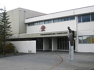
Fjölbrautaskólinn í Breiðholti
School in Reykjavík, Iceland
Distance: Approx. 1443 meters
Latitude and longitude: 64.10600278,-21.81872778
Fjölbrautaskólinn í Breiðholti (The polytechnic school in Breiðholt) is an Icelandic higher educational institute and gymnasium. Founded in 1975, the school currently has a student population of around 2800 people divided between about 1600 students in morning classes, about 500 students in evening classes, and about 700 students in summer school. The school is known for offering multiple educational "paths" which has led to some calling it a rounded collection of schools in the same building.

Grímsbær
Distance: Approx. 1853 meters
Latitude and longitude: 64.122115,-21.875314
Grímsbær (Icelandic pronunciation: [ˈkrimsˌpaiːr̥]) is a small shopping centre in the middle of Reykjavík, Iceland. Originally a two-story structure built into a hillside, in 2004 a third floor was built on top of the existing structure and the centre grew to around 2000 m2, which it remains to this day.

Víkingsvöllur
Football stadium in Reykjavík, Iceland
Distance: Approx. 692 meters
Latitude and longitude: 64.11638889,-21.85513889
Víkingsvöllur (Icelandic pronunciation: [ˈviːciŋsˌvœtlʏr̥]) is a football stadium in Reykjavík, Iceland.
Leiknisvöllur
Distance: Approx. 1691 meters
Latitude and longitude: 64.1025,-21.81944444
Leiknisvöllur is a football stadium in Reykjavík, Iceland. It is currently used for football matches and is the home stadium of Leiknir Reykjavík. The stadium holds around 1215, with 525 being seated.
Hertz-völlurinn
Stadium in Iceland
Distance: Approx. 1208 meters
Latitude and longitude: 64.104,-21.851
Hertz-völlurinn is a multi-use stadium in Reykjavík, Iceland. It is currently used mostly for football matches and is the home stadium of Íþróttafélag Reykjavíkur. Its capacity is around 1500.
Weather in this IP's area
clear sky
3 Celsius
-1 Celsius
2 Celsius
4 Celsius
1016 hPa
56 %
1016 hPa
1011 hPa
10000 meters
3.6 m/s
70 degree
07:48:41
18:42:24