Country:
 Poland
Region:
City:
Latitude and Longitude:
Time Zone:
Postal Code:
IP information under different IP Channel
ip-api
Country
Region
City
ASN
Time Zone
ISP
Blacklist
Proxy
Latitude
Longitude
Postal
Route
IPinfo
Country
Region
City
ASN
Time Zone
ISP
Blacklist
Proxy
Latitude
Longitude
Postal
Route
MaxMind
Country
Region
City
ASN
Time Zone
ISP
Blacklist
Proxy
Latitude
Longitude
Postal
Route
Luminati
Country
PLRegion
14
City
radzymin
ASN
Time Zone
Europe/Warsaw
ISP
Netia SA
Latitude
Longitude
Postal
db-ip
Country
Region
City
ASN
Time Zone
ISP
Blacklist
Proxy
Latitude
Longitude
Postal
Route
ipdata
Country
Region
City
ASN
Time Zone
ISP
Blacklist
Proxy
Latitude
Longitude
Postal
Route
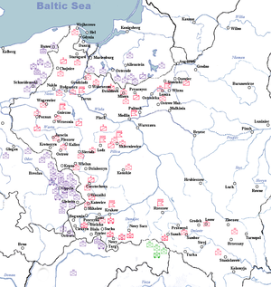
Popular places and events near this IP address

Łaziska Górne
Place in Silesian Voivodeship, Poland
Distance: Approx. 4511 meters
Latitude and longitude: 50.15,18.85
Łaziska Górne [waˈʑiska ˈɡurnɛ] (German: Ober Lazisk, Silesian: Gōrne Łaziska) is a town in Silesia in southern Poland, near Katowice. Outer town of the Metropolis GZM – metropolis with the population of 2 million. Located in the Silesian Highlands.

Mikołów
Town in Mikołów County, Poland
Distance: Approx. 564 meters
Latitude and longitude: 50.16666667,18.9
Mikołów [miˈkɔwuf] (German: Nikolai, Silesian: Mikołōw) is a town in Silesia, in southern Poland, near the city of Katowice. Outer town of the Metropolis GZM, a metropolis with a population of over 2 million, and is within a greater Katowice-Ostrava metropolitan area populated by about 5,294,000 people. The population of the town is 40,898 (2019).

Podlesie, Katowice
Katowice District in Silesian Voivodeship, Poland
Distance: Approx. 4689 meters
Latitude and longitude: 50.17689444,18.96921667
Podlesie (German: Podlesche) is a district of Katowice. It has an area of 8.28 km2 and in 2007 had 5,240 inhabitants.

Mikołów County
County in Silesian Voivodeship, Poland
Distance: Approx. 564 meters
Latitude and longitude: 50.16666667,18.9
Mikołów County (Polish: powiat mikołowski) is a unit of territorial administration and local government (powiat) in Silesian Voivodeship, southern Poland. It came into being on January 1, 1999, as a result of the Polish local government reforms passed in 1998. Its administrative seat and largest town is Mikołów, which lies 12 kilometres (7 mi) south-west of the regional capital Katowice.
Battle of Mikołów
Distance: Approx. 512 meters
Latitude and longitude: 50.175573,18.904807
The Battle of Mikołów (Polish: Bitwa pod Mikolowem, Bitwa wyrska) refers to the border engagement on September 1 and 2, 1939, that took place in the area of the town of Mikołów, located in the Silesian Voivodeship, during the early stages of the Invasion of Poland in the Second World War.

Wyry
Village in Silesian Voivodeship, Poland
Distance: Approx. 4288 meters
Latitude and longitude: 50.13333333,18.91666667
Wyry ([ˈvɨrɨ]) (German: Wyrow) is a village in Mikołów County, Silesian Voivodeship, in southern Poland. It is the seat of the gmina (administrative district) called Gmina Wyry. It lies approximately 4 kilometres (2 mi) south of Mikołów and 15 km (9 mi) south-west of the regional capital Katowice.
Gmina Wyry
Gmina in Silesian Voivodeship, Poland
Distance: Approx. 4288 meters
Latitude and longitude: 50.13333333,18.91666667
Gmina Wyry (German: Wyrow) is a rural gmina (administrative district) in Mikołów County, Silesian Voivodeship, in southern Poland. Its seat is the village of Wyry, which lies approximately 4 kilometres (2 mi) south of Mikołów and 15 km (9 mi) south-west of the regional capital Katowice. The gmina also contains the village of Gostyń.
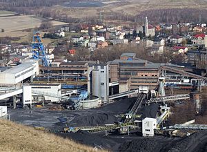
Bolesław Śmiały Coal Mine
Mine in Łaziska Górne, Silesian Voivodeship, Poland
Distance: Approx. 4341 meters
Latitude and longitude: 50.14111111,18.865
The Bolesław Śmiały coal mine is a large mine in the south of Poland in Łaziska Górne, Silesian Voivodeship, 172 km south-west of the capital, Warsaw. Bolesław Śmiały represents one of the largest coal reserve in Poland having estimated reserves of 50 million tonnes of coal. The annual coal production is around 2.13 million tonnes.

Mokre, Mikołów
Sołectwo of Mikołów in Silesian Voivodeship, Poland
Distance: Approx. 3479 meters
Latitude and longitude: 50.178582,18.856758
Mokre (German: Mokrau) is a sołectwo in the west of Mikołów, Silesian Voivodeship, southern Poland. It was an independent village but became administratively part of Mikołów in 1975.

Śmiłowice, Mikołów
Sołectwo of Mikołów in Silesian Voivodeship, Poland
Distance: Approx. 4564 meters
Latitude and longitude: 50.20138889,18.86111111
Śmiłowice (German: Smilowitz) is a sołectwo of Mikołów, Silesian Voivodeship, southern Poland. It was an independent village but as a part of gmina Mokre was administratively merged into Mikołów in 1975.

Kamionka, Mikołów
Mikołów District in Silesian Voivodeship, Poland
Distance: Approx. 2342 meters
Latitude and longitude: 50.18895556,18.92122222
Kamionka is a dzielnica (district) in the north-east of Mikołów, Silesian Voivodeship, southern Poland. It was an independent village but was administratively merged into Mikołów in 1935. It is located alongside national road 81.

Wilkowyje
Distance: Approx. 3993 meters
Latitude and longitude: 50.14833333,18.9475
Wilkowyje (German: Wilkowy) is a dzielnica (district) of Tychy, Silesian Voivodeship, southern Poland. It was an independent village and a seat of gmina, which was absorbed by Tychy in 1951.
Weather in this IP's area
clear sky
14 Celsius
13 Celsius
13 Celsius
16 Celsius
1020 hPa
53 %
1020 hPa
986 hPa
10000 meters
2.59 m/s
4.24 m/s
100 degree
07:11:31
17:47:07