213.209.142.167 - IP Lookup: Free IP Address Lookup, Postal Code Lookup, IP Location Lookup, IP ASN, Public IP
Country:
Region:
City:
Location:
Time Zone:
Postal Code:
ISP:
ASN:
language:
User-Agent:
Proxy IP:
Blacklist:
IP information under different IP Channel
ip-api
Country
Region
City
ASN
Time Zone
ISP
Blacklist
Proxy
Latitude
Longitude
Postal
Route
db-ip
Country
Region
City
ASN
Time Zone
ISP
Blacklist
Proxy
Latitude
Longitude
Postal
Route
IPinfo
Country
Region
City
ASN
Time Zone
ISP
Blacklist
Proxy
Latitude
Longitude
Postal
Route
IP2Location
213.209.142.167Country
Region
schleswig-holstein
City
augsburg
Time Zone
Europe/Berlin
ISP
Language
User-Agent
Latitude
Longitude
Postal
ipdata
Country
Region
City
ASN
Time Zone
ISP
Blacklist
Proxy
Latitude
Longitude
Postal
Route
Popular places and events near this IP address
Treene (Amt)
Former amt in Germany
Distance: Approx. 4618 meters
Latitude and longitude: 54.4625,9.09583333
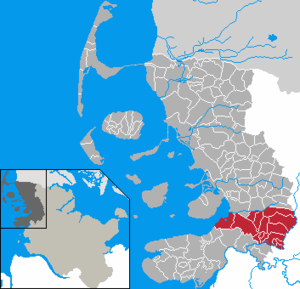
Treene was an Amt ("collective municipality") in the district of Nordfriesland, in Schleswig-Holstein, Germany. It was situated between Husum and the Eider River. Its seat was in Mildstedt.

Immenstedt, Nordfriesland
Municipality in Schleswig-Holstein, Germany
Distance: Approx. 4381 meters
Latitude and longitude: 54.51666667,9.16666667
Immenstedt (Danish: Immingsted) is a municipality in the district of Nordfriesland, in Schleswig-Holstein, Germany.

Horstedt, Schleswig-Holstein
Municipality in Schleswig-Holstein, Germany
Distance: Approx. 2728 meters
Latitude and longitude: 54.51666667,9.06666667
Horstedt (Danish: Horsted, North Frisian: Hoorst) is a municipality in the district of Nordfriesland, in Schleswig-Holstein, Germany.
Arlewatt
Municipality in Schleswig-Holstein, Germany
Distance: Approx. 2728 meters
Latitude and longitude: 54.51666667,9.06666667
Arlewatt (Danish: Arlevad) is a municipality in the district of Nordfriesland, in Schleswig-Holstein, Germany.
Mildstedt
Municipality in Schleswig-Holstein, Germany
Distance: Approx. 4312 meters
Latitude and longitude: 54.46527778,9.09555556
Mildstedt (Danish: Mildsted) is a municipality in the district of Nordfriesland, in Schleswig-Holstein, Germany.
Olderup
Municipality in Schleswig-Holstein, Germany
Distance: Approx. 1696 meters
Latitude and longitude: 54.51666667,9.11666667
Olderup is a municipality in the district of Nordfriesland, in Schleswig-Holstein, Germany.

Schwesing
Municipality in Schleswig-Holstein, Germany
Distance: Approx. 2031 meters
Latitude and longitude: 54.5,9.13333333
Schwesing (Danish: Svesing, North Frisian: Swiasing) is a municipality in the district of Nordfriesland, in Schleswig-Holstein, Germany.
Wester-Ohrstedt
Municipality in Schleswig-Holstein, Germany
Distance: Approx. 4381 meters
Latitude and longitude: 54.51666667,9.16666667
Wester-Ohrstedt (Danish: Vester Ørsted) is a municipality in the district of Nordfriesland, in Schleswig-Holstein, Germany.
Husum Schwesing Airport
Airport in Husum, Germany
Distance: Approx. 3007 meters
Latitude and longitude: 54.51527778,9.14472222
Husum Schwesing Airport (IATA: QHU, ICAO: EDXJ) is a regional airport in Germany. It supports general aviation with no commercial airline service scheduled.
Husum-Schwesing concentration camp
A satellite of Neuengamme concentration camp on 26 September 1944
Distance: Approx. 1214 meters
Latitude and longitude: 54.50994444,9.11811111
The Husum-Schwesing subcamp (German: KZ-Außenlager Husum-Schwesing) in the Schwesing district of Engelsburg, about five kilometres northeast of Husum, became a satellite of Neuengamme concentration camp on 26 September 1944 and was occupied by prisoners in connection with the construction of the so-called Frisian Wall (Friesenwall). Some 2,500 people from 14 countries were incarcerated here in autumn 1944; 297 prisoners died as a result of forced labour, malnutrition and abuse. The camp was closed on 29 December 1944.
Schloss vor Husum
Castle in Husum
Distance: Approx. 4310 meters
Latitude and longitude: 54.4798,9.0503
The Castle in front of Husum (German: Schloss vor Husum), so named because it was outside the city boundary when it was built, is situated in Husum, in the district of North Frisia in the state of Schleswig-Holstein. It was initially a secondary residence of the ducal house of Schleswig-Holstein-Gottorf and served as an occasional residence for the Danish royal family during the 18th and 19th centuries. It also accommodated administrative offices, which gradually expanded and after 1864 occupied most of the building.
Hermann Tast School
German grammar school in Schleswig-Holstein (founded in 1527)
Distance: Approx. 4395 meters
Latitude and longitude: 54.47277778,9.06055556
The Hermann Tast School (German:Hermann-Tast-Schule) is a humanistic high school in Husum. It was founded in 1527 and named after the theologian Hermann Tast (1490–1551), who was born in Husum. Before 1914, it was called the Husum Grammar School (German:Husumer Gelehrtenschule).
Weather in this IP's area
light rain
2 Celsius
-3 Celsius
2 Celsius
2 Celsius
997 hPa
94 %
997 hPa
996 hPa
5158 meters
6.95 m/s
13.55 m/s
141 degree
100 %


