213.193.32.227 - IP Lookup: Free IP Address Lookup, Postal Code Lookup, IP Location Lookup, IP ASN, Public IP
Country:
Region:
City:
Location:
Time Zone:
Postal Code:
ISP:
ASN:
language:
User-Agent:
Proxy IP:
Blacklist:
IP information under different IP Channel
ip-api
Country
Region
City
ASN
Time Zone
ISP
Blacklist
Proxy
Latitude
Longitude
Postal
Route
db-ip
Country
Region
City
ASN
Time Zone
ISP
Blacklist
Proxy
Latitude
Longitude
Postal
Route
IPinfo
Country
Region
City
ASN
Time Zone
ISP
Blacklist
Proxy
Latitude
Longitude
Postal
Route
IP2Location
213.193.32.227Country
Region
copperbelt
City
kitwe
Time Zone
Africa/Lusaka
ISP
Language
User-Agent
Latitude
Longitude
Postal
ipdata
Country
Region
City
ASN
Time Zone
ISP
Blacklist
Proxy
Latitude
Longitude
Postal
Route
Popular places and events near this IP address

Kitwe
City in Copperbelt, Zambia
Distance: Approx. 5645 meters
Latitude and longitude: -12.81666667,28.2
Kitwe is the third largest city in terms of infrastructure development (after Lusaka and Ndola) and second largest city in terms of size and population (after Lusaka) in Zambia. With a population of 517,543 (2010 census provisional) Kitwe is one of the most developed commercial and industrial areas in the nation, alongside Ndola and Lusaka. It has a complex of mines on its north-western and western edges.

Nkana
Copper mining district in the city of Kitwe, Copperbelt Province, Zambia
Distance: Approx. 6628 meters
Latitude and longitude: -12.83333333,28.2
Nkana is a section of the city of Kitwe, Copperbelt Province, Zambia which started off in the early part of the 20th century as a railway station to support the growing complex of copper mining operations. It was named after Chief Nkana, the local traditional ruler. The copper mines of Nkana (South Ore Body, Nkana Mine and Mindola Shaft) were originally owned by the Anglo-American Corporation of South Africa.
Garden Park
Multi-use stadium in Kitwe, Zambia
Distance: Approx. 3044 meters
Latitude and longitude: -12.79138889,28.21972222
Garden Park is a multi-use stadium in Kitwe, Zambia. It is currently used mostly for football matches and serves as the home for Kitwe United Football Club. The stadium holds 10,000 people.
Arthur Davies Stadium
Multi-use stadium in Kitwe, Zambia
Distance: Approx. 5584 meters
Latitude and longitude: -12.84388889,28.23277778
Arthur Davies Stadium is a multi-use stadium in Kitwe, Zambia, named after Arthur Walter Davies who was a FIFA-accredited referee and active member of the Zambian FA. Whilst General Manager of the Copperbelt Power Corporation (now the Copperbelt Energy Corporation) which was based in Kitwe, he established the Power Dynamos F.C. and the stadium. The current stadium no longer meets FIFA standards and therefore is being rebuilt. The new stadium will seat 15,500 people, with about 20% of the seats being in the grandstand and the rest in open wings.
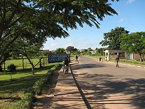
Copperbelt University
Public university in Kitwe, Zambia
Distance: Approx. 1333 meters
Latitude and longitude: -12.80555556,28.24027778
The Copperbelt University is a public university in Kitwe, Zambia. It is the second largest public university in Zambia. The language of instruction at the university is English.
Nkana Stadium
Distance: Approx. 6949 meters
Latitude and longitude: -12.84722222,28.21111111
Nkana Stadium, previously known as Scrivener Stadium, is a multi-use stadium in Kitwe, Zambia. It serves as home stadium for MTN/FAZ Super League side Nkana F.C. The stadium underwent extensive renovations in 2013 that were sponsored by Mopani Copper Mines. In 1959 the stadium hosted a friendly between Northern Rhodesia and Bolton Wanderers.

Kitwe District
District in Copperbelt Province, Zambia
Distance: Approx. 5106 meters
Latitude and longitude: -12.75,28.25
Kitwe District is a district of Zambia, located in Copperbelt Province. The capital is Kitwe. As of the 2022 Zambian Census, the district had a population of 661,901 people.
Ek Park
Cricket ground in Kitwe, Zambia
Distance: Approx. 5622 meters
Latitude and longitude: -12.82954167,28.20886111
Ek Park is a cricket ground in Kitwe, Zambia. The first recorded match on the ground came in 1957 when Northern Rhodesia played the touring Australians. The ground later held its first first-class match in 1962 when Rhodesia played a touring International XI, resulting in a drawn match.
Zambia Riverside Solar Power Station
Zambian solar farm
Distance: Approx. 1745 meters
Latitude and longitude: -12.80722222,28.23638889
The Zambia Riverside Solar Power Station is a 34 megawatts solar power plant in Zambia. The privately owned solar farm was originally commissioned in April 2018, as a 1 MW power station by Copperbelt Energy Corporation (CEC), who own the energy infrastructure. In December 2021, CEC signed an engineering, procurement, and construction (EPC) contract with Sinohydro to expand the solar farm by 33 extra MW over the next 12 months.
Kitwe Teaching Hospital
Zambian public referral hospital
Distance: Approx. 4044 meters
Latitude and longitude: -12.79777778,28.2102
Kitwe Central Hospital, also known as Kitwe Teaching Hospital, is third level public tertiary referral hospital in Kitwe, Zambia. The hospital has 630 beds. The facility was opened in 1958.
Weather in this IP's area
overcast clouds
17 Celsius
18 Celsius
17 Celsius
17 Celsius
1012 hPa
98 %
1012 hPa
879 hPa
10000 meters
1.71 m/s
4.2 m/s
291 degree
100 %
