213.191.228.217 - IP Lookup: Free IP Address Lookup, Postal Code Lookup, IP Location Lookup, IP ASN, Public IP
Country:
 Ireland
Region:
City:
Location:
Time Zone:
Postal Code:
ISP:
ASN:
language:
User-Agent:
Proxy IP:
Blacklist:
IP information under different IP Channel
ip-api
Country
Region
City
ASN
Time Zone
ISP
Blacklist
Proxy
Latitude
Longitude
Postal
Route
db-ip
Country
Region
City
ASN
Time Zone
ISP
Blacklist
Proxy
Latitude
Longitude
Postal
Route
IPinfo
Country
Region
City
ASN
Time Zone
ISP
Blacklist
Proxy
Latitude
Longitude
Postal
Route
IP2Location
213.191.228.217Country
ieRegion
cavan
City
bailieborough
Time Zone
Europe/Dublin
ISP
Language
User-Agent
Latitude
Longitude
Postal
ipdata
Country
Region
City
ASN
Time Zone
ISP
Blacklist
Proxy
Latitude
Longitude
Postal
Route
Popular places and events near this IP address

Bailieborough
Town in County Cavan, Ireland
Distance: Approx. 274 meters
Latitude and longitude: 53.916885,-6.970875
Bailieborough or Bailieboro (; Irish: Coill an Chollaigh, meaning 'the wood of the boar') is a town and civil parish in County Cavan, Ireland. As of the 2022 census, the population was 2,974, up from 1,529 as of the 1996 census. Bailieborough's proximity to the N3 national road has made it a commuter town.

Killinkere
Parish in County Cavan, Ireland
Distance: Approx. 7216 meters
Latitude and longitude: 53.88694444,-7.06444444
Killinkere (Irish: Cillín Chéir, meaning 'Little Black Church') is a civil and ecclesiastical parish of County Cavan, Ireland. It is located between the towns of Virginia and Bailieborough.
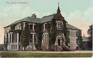
Bailieborough Castle
Former castle in County Cavan, Ireland
Distance: Approx. 2108 meters
Latitude and longitude: 53.9293,-6.9907
Bailieborough Castle was located in Bailieborough, County Cavan, Ireland. It was built in an enclosed demesne by 1629. Also known as Castle House, Lisgar House, or simply 'The Castle', the country house was located just to the south-west of Castle Lough in what is now known as Bailieborough Demesne, on the north-western edge of the town.

Knockbride
Parish in County Cavan, Ireland
Distance: Approx. 7435 meters
Latitude and longitude: 53.974,-7.025
Knockbride (Irish: Cnoca Bríde, meaning 'hill of Bríd') is a civil parish in County Cavan, Ireland. It is located to the north of the town of Bailieborough. There are two Roman Catholic churches in the parish – both are dedicated to Saint Brigid (Bríd) and located in the Diocese of Kilmore.
Canningstown
Village in County Cavan, Ireland
Distance: Approx. 8813 meters
Latitude and longitude: 53.9803,-7.0468
Canningstown (Irish: Baile Chainín) is a village in northeastern County Cavan, Ireland. It is located in the civil parish of Knockbride on the R191 regional road, 12 kilometres (7 mi) south of Cootehill and 10 km (6 mi) north of Bailieborough.
Finternagh
Townland in Ulster, Republic of Ireland
Distance: Approx. 4911 meters
Latitude and longitude: 53.87361111,-6.98277778
Finternagh is a townland in County Cavan, Ireland. The townland covers 295 acres (1.19 km2). Finternagh is one of a number townlands of the Irish civil parish of Killinkere in the barony of Castlerahan, County Cavan, Province of Ulster.

Upper Lough Skeagh
Distance: Approx. 5065 meters
Latitude and longitude: 53.95416667,-7.01055556
Upper Lough Skeagh is a freshwater lake in the northeast of Ireland. It is located in County Cavan in the catchment of the River Boyne.
Bailieborough Community School
Community school in Ireland
Distance: Approx. 629 meters
Latitude and longitude: 53.9129,-6.9738
Bailieborough Community School, alternatively spelled as Bailieboro, and commonly referred to as BCS, is a community school located in the town of Bailieborough, County Cavan, Ireland. The school was an amalgamation of two previous schools in the town; Bailieborough Vocation School, colloquially called The Tech; and Lourdesville Secondary School, colloquially referred to as 'The Convent'. The school was built on the site of the existing Lourdesville School, and was opened on the 8 November 1982 by the then Minister for Posts and Telegraphs, John Wilson.
Bailieborough Shamrocks GAA
Cavan-based Gaelic games club
Distance: Approx. 1055 meters
Latitude and longitude: 53.926037,-6.969501
Bailieboro Shamrocks Gaelic Athletic Association (also spelled Bailieborough) is a Gaelic football, camogie and ladies' Gaelic football club based in Bailieborough, County Cavan in Ireland.
Old Moybologue Cemetery
Cemetery in County Cavan, Ireland
Distance: Approx. 5093 meters
Latitude and longitude: 53.87194444,-6.95055556
Old Moybologue Cemetery is a circular enclosure in County Cavan, Ireland. The site dates from the Early Christian Period and features the ruins of a mediaeval church and a graveyard.
East Cavan Gaels GAA
Distance: Approx. 1032 meters
Latitude and longitude: 53.9259,-6.9687
East Cavan Gaels GAA is a Gaelic Athletic Association club located in East Cavan, Ireland. The club is primarily concerned with the game of hurling.
Corleck Hill
Drumlin in County Cavan, Ireland
Distance: Approx. 6542 meters
Latitude and longitude: 53.9726,-6.9975
Corleck Hill (Irish: Sliabh na Trí nDée or Sliabh na Trí nDée Dána, meaning 'Hill of the Three Gods') is a small elongated promontory (Irish: drumlin) in the townland of Drumeague, County Cavan, Ireland. A 3rd century BC passage grave on the hill was dismantled on Corleck in the mid-19th century, and the hill it is once thought to have contained an ancient sacred well. The 1st century AD Celtic stone idols, the Corleck Head and Corraghy Heads (collectively known as the "Corleck Gods"), are thought to have been uncovered during the excavation.
Weather in this IP's area
overcast clouds
3 Celsius
-0 Celsius
3 Celsius
3 Celsius
1026 hPa
71 %
1026 hPa
1010 hPa
10000 meters
4.64 m/s
9.7 m/s
78 degree
100 %