213.188.190.6 - IP Lookup: Free IP Address Lookup, Postal Code Lookup, IP Location Lookup, IP ASN, Public IP
Country:
Region:
City:
Location:
Time Zone:
Postal Code:
IP information under different IP Channel
ip-api
Country
Region
City
ASN
Time Zone
ISP
Blacklist
Proxy
Latitude
Longitude
Postal
Route
Luminati
Country
City
lesabymes
ASN
Time Zone
America/Guadeloupe
ISP
Canal + Telecom SAS
Latitude
Longitude
Postal
IPinfo
Country
Region
City
ASN
Time Zone
ISP
Blacklist
Proxy
Latitude
Longitude
Postal
Route
IP2Location
213.188.190.6Country
Region
reunion
City
reunion
Time Zone
Indian/Reunion
ISP
Language
User-Agent
Latitude
Longitude
Postal
db-ip
Country
Region
City
ASN
Time Zone
ISP
Blacklist
Proxy
Latitude
Longitude
Postal
Route
ipdata
Country
Region
City
ASN
Time Zone
ISP
Blacklist
Proxy
Latitude
Longitude
Postal
Route
Popular places and events near this IP address

Saint-Paul, Réunion
Subprefecture and commune in Réunion, France
Distance: Approx. 6353 meters
Latitude and longitude: -21.0097,55.2697
Saint-Paul (French pronunciation: [sɛ̃ pɔl] ) is the second-largest commune in the French overseas department of Réunion. It is located on the extreme west side of the island of Réunion. Until 1999, near Saint Paul there was the 428-metre (1,404 ft) tall mast OMEGA Chabrier transmitter.

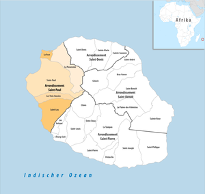
Arrondissement of Saint-Paul
Arrondissement in Réunion, France
Distance: Approx. 6481 meters
Latitude and longitude: -21.00861111,55.27083333
The arrondissement of Saint-Paul is an arrondissement of France in the Réunion department in the Réunion region. It has five communes. Its population is 215,613 (2021), and its area is 537.2 km2 (207.4 sq mi).

Les Trois-Bassins
Commune in Réunion, France
Distance: Approx. 5252 meters
Latitude and longitude: -21.1058,55.295
Les Trois-Bassins (French pronunciation: [le tʁwɑ basɛ̃], lit. 'The Three Basins') is a commune in the department of Réunion. It is found on the west coast of the island, and the summit of Grand Bénare lies within its borders. The commune borders Cilaos to the west, Saint-Paul to the north and Saint-Leu to the south.
Pointe des Aigrettes
Distance: Approx. 6131 meters
Latitude and longitude: -21.0375,55.21666667
The Pointe des Aigrettes is a headland on the island of Réunion in the Indian Ocean. Located in the commune of Saint-Paul, along the island's western coast, it marks the westernmost point of the territory, and may be found close to the entrance to Saint-Gilles-les-Bains along Route nationale 1.

Saint-Gilles, Réunion
Distance: Approx. 1999 meters
Latitude and longitude: -21.04888889,55.26916667
Saint-Gilles is a village located along the west coast of the island of Réunion, in the commune of Saint-Paul. It is the site of the island's most popular seaside resort.

Raid on Saint-Paul
Part of the Napoleonic Wars
Distance: Approx. 7425 meters
Latitude and longitude: -21,55.26666667
The raid on Saint-Paul was an amphibious operation conducted by British forces against the port of Saint-Paul in the French colony of Isle Bonaparte during the Napoleonic Wars. It was launched on 20 September 1809 as both a precursor to a future full-scale invasion of Isle Bonaparte and in order to capture the French frigate Caroline and the East Indiamen she had seized in the action of 31 May 1809 which were sheltering in the harbour. The operation was a complete success, with British storming parties capturing the batteries overlooking the port, which allowed a naval squadron under Commodore Josias Rowley to enter the bay and capture the shipping in the harbour.
Stade Paul Julius Bénard
Distance: Approx. 9688 meters
Latitude and longitude: -20.9825,55.29027778
The Olympic Stade Paul-Julius-Bénard, or officially the Stade olympique Bénard-Paul-Julius, is a stadium of the island of Réunion, Department of Overseas French and outermost region of the European Union in the southwest of the Indian Ocean. Main stadium of the town of St. Paul, it has a capacity of 8,500 seats at the games of the Saint-Pauloise FC and 12,000 for concerts.

Conservatoire botanique national de Mascarin
Distance: Approx. 8443 meters
Latitude and longitude: -21.1377,55.2953
The Conservatoire botanique national de Mascarin (12.5 hectares) is a national conservatory and botanical garden located at 2, rue du Père Georges, Colimaçons, Saint-Leu, Réunion, France. It is open daily except Monday; an admission fee is charged. The conservatory was established in 1986 as the Conservatoire et Jardin Botanique de Mascarin on farmland belonging to the family of the Marquis Antoine Sosthène Armand de Châteauvieux, at an elevation of 500 meters on the leeward side of La Réunion.

Réunion's coral reef
Distance: Approx. 5132 meters
Latitude and longitude: -21.0851,55.2214
Réunion is an island located near the eastern coast of Madagascar in the Indian Ocean. Its coral reef covers a concentrated part of the western littoral. The coral reef is located between St Leu and St Gilles.

Kélonia
Zoo in Réunion, France
Distance: Approx. 9650 meters
Latitude and longitude: -21.152469,55.280206
Kélonia is a public aquarium and observatory specialising in Marine turtles in Saint-Leu, Réunion. It was built on the site of a former Turtle Ranch and hosts guided visits and educational workshops. Kélonia participates in different research programs on marine turtles.
Cantons of Saint-Paul
Distance: Approx. 6321 meters
Latitude and longitude: -21.01,55.27
The cantons of Saint-Paul are administrative divisions of Réunion, an overseas department and region of France. Since the French canton reorganisation which came into effect in March 2015, the city of Saint-Paul is subdivided into 3 cantons. Their seat is in Saint-Paul.
Weather in this IP's area
clear sky
25 Celsius
25 Celsius
23 Celsius
25 Celsius
1017 hPa
77 %
1017 hPa
970 hPa
10000 meters
1.31 m/s
2.18 m/s
154 degree
9 %
