Country:
Region:
City:
Latitude and Longitude:
Time Zone:
Postal Code:
IP information under different IP Channel
ip-api
Country
Region
City
ASN
Time Zone
ISP
Blacklist
Proxy
Latitude
Longitude
Postal
Route
Luminati
Country
Region
mow
City
moscow
ASN
Time Zone
Europe/Moscow
ISP
Melbikomas UAB
Latitude
Longitude
Postal
IPinfo
Country
Region
City
ASN
Time Zone
ISP
Blacklist
Proxy
Latitude
Longitude
Postal
Route
db-ip
Country
Region
City
ASN
Time Zone
ISP
Blacklist
Proxy
Latitude
Longitude
Postal
Route
ipdata
Country
Region
City
ASN
Time Zone
ISP
Blacklist
Proxy
Latitude
Longitude
Postal
Route
Popular places and events near this IP address

Grand Kremlin Palace
Palace
Distance: Approx. 206 meters
Latitude and longitude: 55.75,37.6158
The Grand Kremlin Palace (Russian: Большой Кремлёвский дворец, romanized: Bolshoy Kremlyovskiy dvorets) is a building in the Moscow Kremlin. For much of the 19th century, it served as the official residence of the Russian emperor in Moscow, which was not then the capital of the Russian Empire. Designed by a team of architects under the management of Konstantin Thon, architect of the Kremlin Armoury and the Cathedral of Christ the Saviour, the palace was intended to emphasise the greatness of Russian autocracy.

Palace of Facets
Architectural monument in the Moscow Kremlin
Distance: Approx. 222 meters
Latitude and longitude: 55.75027778,37.61666667
The Palace of the Facets (Russian: Грановитая палата, romanized: Granovitaya palata) is a building in the Moscow Kremlin, Russia, which contains what used to be the main banquet reception hall of the Russian tsars. It is the oldest preserved secular building in Moscow. Located on Kremlin Cathedral Square, between the Cathedral of the Annunciation and the Dormition Cathedral.
Red Porch
Distance: Approx. 220 meters
Latitude and longitude: 55.75027778,37.61694444
The Red Porch or Red Staircase (Russian: Красное крыльцо, Krasnoe Kryltso), decorated with stone lions, leads into the Palace of Facets in the Kremlin, Moscow. In old Russian the word krasny meant "beautiful", but today it means "red". This is the same word used for "Red Square".

Cathedral of the Archangel
Church in Moscow, Russia
Distance: Approx. 224 meters
Latitude and longitude: 55.75027778,37.61777778
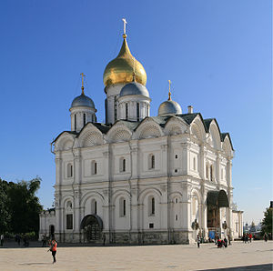
The Cathedral of the Archangel (Russian: Архангельский собор, romanized: Arkhangel'skiy sobor) is a Russian Orthodox church dedicated to the Archangel Michael. It is located in Cathedral Square of the Moscow Kremlin in Russia between the Great Kremlin Palace and the Ivan the Great Bell Tower. It was the main necropolis of the tsars of Russia until the relocation of the capital to St.

Cathedral of the Annunciation, Moscow
Church in Moscow, Russia
Distance: Approx. 189 meters
Latitude and longitude: 55.75,37.61694444
The Cathedral of the Annunciation (Russian: Благовещенский собор, romanized: Blagoveschensky sobor) in Moscow is a Russian Orthodox church dedicated to the Annunciation of the Theotokos. It is located on the southwest side of Cathedral Square in the Moscow Kremlin in Russia, where it connects directly to the main building of the complex of the Grand Kremlin Palace, adjacent to the Palace of Facets. It was originally the personal chapel for the tsars, and its abbot remained a personal confessor of the Russian royal family until the early 20th century.

Moscow Kremlin Wall
Defensive wall around the Moscow Kremlin
Distance: Approx. 100 meters
Latitude and longitude: 55.74916667,37.61666667
The Moscow Kremlin Wall is a defensive wall that surrounds the Moscow Kremlin, recognisable by the characteristic notches and its Kremlin towers. The original walls were likely a simple wooden fence with guard towers built in 1156. The Kremlin walls, like many cathedrals in the Kremlin, were built by Italian architects.

Central Administrative Okrug
Administrative okrug of Moscow in Russia
Distance: Approx. 191 meters
Latitude and longitude: 55.75,37.61666667
Central Administrative Okrug, or Tsentralny Administrativny Okrug (Russian: Центра́льный администрати́вный о́круг, Tsentralny administrativny okrug), is one of the twelve administrative okrugs of Moscow, Russia. Population: 772,258 (2021 Census); 741,967 (2010 Census); 701,353 (2002 Census); . It is the core of the city that includes its oldest, historical parts: Kremlin and the former Bely Gorod and Zemlyanoy Gorod; with certain churches and fortifications as old as from the 14th to 15th century.

Climate of Moscow
Climate of the capital of Russia
Distance: Approx. 191 meters
Latitude and longitude: 55.75,37.61666667
Moscow has a warm-summer humid continental climate (Köppen climate classification Dfb) with warm to hot summers and long, cold, winters. Typical high temperatures in the warm months of June, July and August are around 23 °C (73 °F), but during heat waves, which can occur anytime from May to September, daytime temperature highs often top 30 °C (86 °F) sometimes one or two weeks. In the winter, temperatures normally drop to approximately −10 °C (14 °F), though there can be periods of warmth with temperatures rising above 0 °C (32 °F).

Zemlyanoy Gorod
Distance: Approx. 191 meters
Latitude and longitude: 55.75,37.61666667
Zemlyanoy Gorod (Russian: Земляной город, IPA: [zʲɪmlʲɪˈnoj ˈɡorət] "Earthworks City") in 17th-century Moscow was the outer ring of the city, surrounded by ramparts and a moat. It surrounded the older moat built by Aloisio the New in the early 16th century which delimited Bely Gorod. Historical Zemlyanoy Gorod corresponds to the area now in between the Boulevard Ring and the Garden Ring roads.

Trams in Moscow
Tram system in Moscow, Russia
Distance: Approx. 191 meters
Latitude and longitude: 55.75,37.61666667
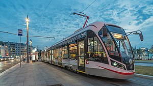
The Moscow tramway network, which is divided into two sub-networks, is a key element of the public transport system in Moscow, the capital city of Russia. Opened in 1872, it has been operated since 1958 until 2021 by Mosgortrans, a state-owned company.
Timeline of Moscow
Distance: Approx. 191 meters
Latitude and longitude: 55.75,37.616667
The following is a timeline of the history of the city of Moscow, Russia.

House of Lobkov on the Sophia Embankment
Building in Sofiyskaya naberezhnaya, house
Distance: Approx. 97 meters
Latitude and longitude: 55.74777778,37.61833333
The House of Lobkov on the Sophia Embankment (Russian: Дом Лобкова на Софийской набережной) is a mansion in the center of Moscow (Sofia embankment, house 22). Built around 1816 in the Empire style. It was rebuilt in 2003 with a superstructure of the attic floor.
Weather in this IP's area
overcast clouds
4 Celsius
-0 Celsius
3 Celsius
4 Celsius
1000 hPa
70 %
1000 hPa
983 hPa
10000 meters
5.78 m/s
11.73 m/s
223 degree
100 %
08:11:28
16:18:19
