Country:
 Hungary
Region:
City:
Latitude and Longitude:
Time Zone:
Postal Code:
IP information under different IP Channel
ip-api
Country
Region
City
ASN
Time Zone
ISP
Blacklist
Proxy
Latitude
Longitude
Postal
Route
IPinfo
Country
Region
City
ASN
Time Zone
ISP
Blacklist
Proxy
Latitude
Longitude
Postal
Route
MaxMind
Country
Region
City
ASN
Time Zone
ISP
Blacklist
Proxy
Latitude
Longitude
Postal
Route
Luminati
Country
 US
USRegion
de
ASN
Time Zone
America/New_York
Latitude
Longitude
Postal
db-ip
Country
Region
City
ASN
Time Zone
ISP
Blacklist
Proxy
Latitude
Longitude
Postal
Route
ipdata
Country
Region
City
ASN
Time Zone
ISP
Blacklist
Proxy
Latitude
Longitude
Postal
Route
Popular places and events near this IP address

Újlipótváros
Distance: Approx. 131 meters
Latitude and longitude: 47.5186,19.0542
Újlipótváros ("New Leopold Town") is a neighborhood in the 13th district of Budapest, Hungary. It is located north to Lipótváros ("Leopold Town") neighbourhood of the 5th District, with the Szent István Boulevard (Szent István körút) separating it from its southern neighbor, Lipótváros. It lies east of the river Danube, west of Terézváros, and south of Vizafogó.

Margaret Bridge
Three-way bridge in Budapest, Hungary
Distance: Approx. 979 meters
Latitude and longitude: 47.51472222,19.04361111
Margaret Bridge (sometimes Margit Bridge) or Margit híd (Hungarian pronunciation: [ˈmɒrgit ˈhiːd]) is a three-way bridge in Budapest, Hungary, connecting Buda and Pest across the Danube and linking Margaret Island to the banks. It is the second-northernmost and second-oldest public bridge in Budapest. It was designed by French engineer Ernest Goüin and built by the construction company Maison Ernest Goüin et Cie.

Budapest Nyugati station
Railway station in Budapest, Hungary
Distance: Approx. 809 meters
Latitude and longitude: 47.51083333,19.0575
Budapest Nyugati station (Hungarian: Nyugati pályaudvar, pronounced [ˈɲuɡɒti ˈpaːjɒudvɒr]; lit. 'western railway station'), generally referred to simply as Nyugati, is one of the three main railway terminals in Budapest, Hungary. The station is on the Pest side of Budapest, accessible by the 4 and 6 tramline and the M3 metro line.

Lehel tér metro station
Budapest metro station
Distance: Approx. 369 meters
Latitude and longitude: 47.5175,19.06055556
Lehel tér is a station on the Budapest Metro M3 line. It opened on 30 December 1981 with the third phase of the M3 rollout. It was the first phase to run northbound from Deák tér on the line.

Dózsa György út metro station
Budapest metro station
Distance: Approx. 895 meters
Latitude and longitude: 47.52416667,19.06333333
Dózsa György út (Hungarian pronunciation: [ˈdoːʒɒ ˈɟørɟ ˈuːt]) is a station on the Budapest Metro Line 3 (North-South). It is located beneath Váci Avenue at its intersection with the eponymous street Dózsa György út. The station was opened on 7 November 1984 as part of the extension from Lehel tér to Árpád híd.

WestEnd City Center
Shopping mall in Budapest, Hungary
Distance: Approx. 711 meters
Latitude and longitude: 47.511725,19.05749167
The Westend Shopping Center is a shopping centre built by Hungarian TriGránit Ltd. located next to the Western Railway Station, in Budapest, Hungary. Opened on 12 November 1999, it is known for having been the largest mall in Central Europe until larger ones were inaugurated, including Arena Plaza, also in Pest.

Nyugati pályaudvar metro station
Budapest metro station
Distance: Approx. 740 meters
Latitude and longitude: 47.51138889,19.05666667
Nyugati pályaudvar (Western Railway Station) is a station on the M3 (North-South) line of the Budapest Metro. It is nominally located on the borders of District V, District VI and District XIII, the station itself is under Váci Road at between its intersections with Grand Boulevard and Katona József Street. The station was opened on 30 December 1981 as part of the extension of the line from Deák Ferenc tér to Lehel tér.
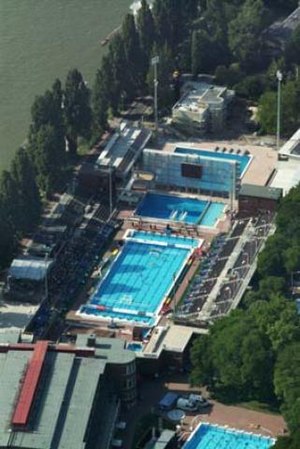
Alfréd Hajós National Swimming Stadium
Distance: Approx. 1042 meters
Latitude and longitude: 47.52138889,19.04277778
The Alfréd Hajós National Swimming Stadium is an aquatics complex located on Margaret Island in Budapest, Hungary.The facility has four floors, covers an area of about 80,000 square meters and has eight indoor and outdoor pools, including training pools, diving pools and competitive swimming pools both for short course and long course. The indoor swimming pool was built in 1930, off the plans of the renowned Hungarian swimmer and architect Alfréd Hajós, of whom the centre takes its name after. Eszter Pécsi, Hungary's first female architect and structural engineer, designing the articulated reinforced concrete arches.

Hableány disaster
2019 maritime incident in Hungary
Distance: Approx. 926 meters
Latitude and longitude: 47.51388889,19.045
Hableány ([ˈhɒblɛaːɲ]; Hungarian for 'Mermaid') was a 27-metre (89 ft) river cruiser operated on the Danube river in Budapest, Hungary. On the rainy night of May 29, 2019, at 9:05 pm the 135-metre (443 ft) Viking Sigyn collided with Hableány from behind under the Margaret Bridge near the Parliament Building. Hableány sank in 7 seconds.
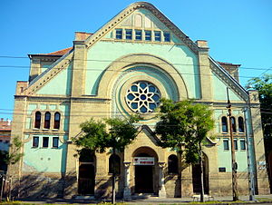
Dózsa György Street Synagogue
Former synagogue in Budapest, Hungary
Distance: Approx. 1001 meters
Latitude and longitude: 47.52239,19.06732
The Dózsa György Street Synagogue (Hungarian: Dózsa György úti zsinagóga), or Angyalföld Synagogue, is a former Orthodox Jewish synagogue located on Dózsa György Street (formerly Aréna Street), in Újlipótváros, in the XIII District of Budapest, in Hungary. Completed as a synagogue in 1909, used as a concentration camp during World War II, and subsequently for profaned use, the building was repurposed in 1984 as an indoor sports center by the Budapest Honvéd Sports Association as a fencing hall. The congregation continues to worship in the cultural hall located on the site; led by Rabbi Peter Deutsch.
Lipótváros Synagogue (Budapest)
Proposed synagogue in Budapest, Hungary
Distance: Approx. 1075 meters
Latitude and longitude: 47.50874,19.05165
The Lipótváros Synagogue was a planned but never realized monumental Jewish synagogue that was to be located on Ignác Nagy Street, in Lipótváros, Budapest, Hungary. It was planned to build the synagogue at the beginning of the 20th century and it would have had a capacity of 3,800 people. In the end, the building was not completed due to financial difficulties.

Columbo statue
Statue of Lt. Columbo
Distance: Approx. 783 meters
Latitude and longitude: 47.51265,19.04893
The Columbo statue is a life-sized bronze work on Falk Miksa Street in Budapest depicting Peter Falk in the role of the fictional police detective Columbo. At the Columbo statue's feet is a statue of Columbo's dog, Dog. The statues, by the sculptor Géza Dezső Fekete, were put up in 2014 as part of a state-sponsored urban renewal project.
Weather in this IP's area
clear sky
11 Celsius
10 Celsius
11 Celsius
13 Celsius
1025 hPa
64 %
1025 hPa
1012 hPa
10000 meters
4.63 m/s
110 degree
07:06:54
17:50:31