Country:
Region:
City:
Latitude and Longitude:
Time Zone:
Postal Code:
IP information under different IP Channel
ip-api
Country
Region
City
ASN
Time Zone
ISP
Blacklist
Proxy
Latitude
Longitude
Postal
Route
Luminati
Country
Region
by
City
munich
ASN
Time Zone
Europe/Berlin
ISP
M-net Telekommunikations GmbH
Latitude
Longitude
Postal
IPinfo
Country
Region
City
ASN
Time Zone
ISP
Blacklist
Proxy
Latitude
Longitude
Postal
Route
db-ip
Country
Region
City
ASN
Time Zone
ISP
Blacklist
Proxy
Latitude
Longitude
Postal
Route
ipdata
Country
Region
City
ASN
Time Zone
ISP
Blacklist
Proxy
Latitude
Longitude
Postal
Route
Popular places and events near this IP address

Arabella Hochhaus
Hotel/Apartment in Munich, Germany
Distance: Approx. 805 meters
Latitude and longitude: 48.15111111,11.61833333
The Arabella-Hochhaus is a 23-storey, 75 m (246 ft), combined hotel, office and apartment building at Arabellapark, in the Bogenhausen neighborhood in eastern Munich, Germany.

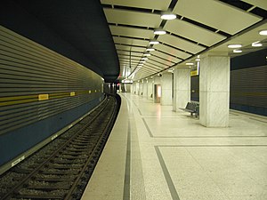
Arabellapark station
Station of the Munich U-Bahn
Distance: Approx. 973 meters
Latitude and longitude: 48.15361111,11.62166667
Arabellapark is a Munich U-Bahn station in Bogenhausen borough. It is the eastern terminus of the U4. Arabellapark station is located in the Arabellapark district of Bogenhausen, a large housing and commercial district developed during the 1970s.

Richard-Strauss-Straße station
Station of the Munich U-Bahn
Distance: Approx. 835 meters
Latitude and longitude: 48.14888889,11.61638889
Richard-Strauss-Straße is a Munich U-Bahn station on the U4 line in the borough of Bogenhausen. It is located on the eastern fringe of Alt-Bogenhausen, the traditional core district. The station takes its name from Richard-Strauss-Straße, part of the Mittlerer Ring road system, that runs above the U-Bahn tracks, which was named for the famed German composer Richard Strauss.

Musicland Studios
Recording studio in Munich established by Giorgio Moroder
Distance: Approx. 935 meters
Latitude and longitude: 48.15010833,11.61950278
Musicland Studios was a recording studio located in Munich, Germany established by Italian record producer, songwriter and musician Giorgio Moroder in the early 1970s. The studios were known for their work with artists such as Donna Summer, Electric Light Orchestra, and Queen, among others.

Ifo Institute for Economic Research
German economic research institute
Distance: Approx. 312 meters
Latitude and longitude: 48.152842,11.605011
The Ifo Institute for Economic Research is a Munich-based research institution. Ifo is an acronym from Information and Forschung (research). As one of Germany's largest economic think-tanks, it analyses economic policy and is known for its monthly Ifo Business Climate Index for Germany.

Bogenhausen
Borough of Munich, Germany
Distance: Approx. 918 meters
Latitude and longitude: 48.14805556,11.61666667
Bogenhausen (Central Bavarian: Bognhausn) is the 13th borough of Munich, Germany. It is the geographically largest borough of Munich and comprises the city's north-eastern quarter, reaching from the Isar on the eastern side of the Englischer Garten to the city limits, bordering on Unterföhring to the north, Aschheim to the east and the Haidhausen borough to the south.

Hypo-Haus
High-rise building is an administrative building of the HypoVereinsbank in Munich
Distance: Approx. 818 meters
Latitude and longitude: 48.14972222,11.61722222
The listed HVB Tower or formerly Hypo-house (Hypo-Haus) or Hypo high-rise building (Hypo-Hochhaus) is an administrative building of the HypoVereinsbank in Munich.
Münchner Bank
German credit union
Distance: Approx. 896 meters
Latitude and longitude: 48.1484,11.6168
The Münchner Bank is a German credit union headquartered in Munich. Founded in 1862, it is the oldest and largest credit union in Bavaria with 525 employees at 41 locations and assets of 2.625 Billion Euros (c. 3700 Million US-Dollar).

Arabellapark
Distance: Approx. 909 meters
Latitude and longitude: 48.1519,11.6203
Arabellapark is a residential and commercial area in the Bogenhausen district of Munich, Germany, which was developed with the construction of multiple buildings from 1965 to 1998. It is one of the largest urban expansion projects of the period after World War II in Munich. It takes its name from the Arabellastrasse, which runs through the project site.

Brunnthaler Quellbach
River in Germany
Distance: Approx. 930 meters
Latitude and longitude: 48.14805556,11.60027778
Brunnthaler Quellbach (also: Quellenbach) is a creek of Munich, Bavaria, Germany. Until the end of the 19th century, the Munich river Brunnbach had its source near Bad Brunnthal in the lower Bogenhausen district and, as today, was a tributary of the Isar at St. Emmeran.

Isarring
Street in Munich, Germany
Distance: Approx. 860 meters
Latitude and longitude: 48.16018,11.60108
The Isarring is a four-lane section of the Mittlerer Ring, the Bundesstraße 2 R (federal highway), in Munich. It is used by 110,000 cars every day and was constructed in 1966.

Chinese Tower
Building in Munich, Germany
Distance: Approx. 1241 meters
Latitude and longitude: 48.1525,11.59211111
The Chinese Tower (German: Chinesischer Turm) is a 25-metre wooden building resembling a pagoda at the Englischer Garten in Munich, Germany. The building was constructed from 1789 to 1790 and was opened to the public as an observation deck during the opening of the Englischer Garten in 1792. The tower burned down during the bombing of Munich during World War II and was reopened as a reconstruction in 1952.
Weather in this IP's area
scattered clouds
5 Celsius
4 Celsius
3 Celsius
6 Celsius
1026 hPa
94 %
1026 hPa
964 hPa
10000 meters
1.4 m/s
1.53 m/s
102 degree
48 %
07:11:38
16:43:17