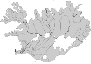
Country:
 Iceland
Region:
City:
Latitude and Longitude:
Time Zone:
Postal Code:
IP information under different IP Channel
ip-api
Country
Region
City
ASN
Time Zone
ISP
Blacklist
Proxy
Latitude
Longitude
Postal
Route
IPinfo
Country
Region
City
ASN
Time Zone
ISP
Blacklist
Proxy
Latitude
Longitude
Postal
Route
MaxMind
Country
Region
City
ASN
Time Zone
ISP
Blacklist
Proxy
Latitude
Longitude
Postal
Route
Luminati
Country
ISRegion
2
City
gardur
ASN
Time Zone
Atlantic/Reykjavik
ISP
Ljosleidarinn ehf
Latitude
Longitude
Postal
db-ip
Country
Region
City
ASN
Time Zone
ISP
Blacklist
Proxy
Latitude
Longitude
Postal
Route
ipdata
Country
Region
City
ASN
Time Zone
ISP
Blacklist
Proxy
Latitude
Longitude
Postal
Route
Popular places and events near this IP address

Keflavík
Town in South Constituency, Iceland
Distance: Approx. 7076 meters
Latitude and longitude: 64.01666667,-22.56666667
Keflavík (pronounced [ˈcʰɛplaˌviːk] , meaning Driftwood Bay) is a town in the Reykjanes region in southwest Iceland. It is included in the municipality of Reykjanesbær whose population as of 2016 is 15,129. In 1995, Keflavík merged with nearby Njarðvík and Hafnir to form the municipality of Reykjanesbær.

Keflavík International Airport
Largest airport serving Reykjavík, Iceland
Distance: Approx. 9730 meters
Latitude and longitude: 63.985,-22.60555556
Keflavík Airport (Icelandic: Keflavíkurflugvöllur [ˈcʰɛplaˌviːkʏrˌflʏɣˌvœtlʏr̥]) (IATA: KEF, ICAO: BIKF), also known as Reykjavík–Keflavík Airport, is the largest airport in Iceland and the country's main hub for international transportation. The airport is 1.7 nautical miles (3.1 kilometres) west of Keflavík and 50 km (30 mi) southwest of Reykjavík. The airport has three runways, two of which are in use, and the airport area is about 25 km2 (10 sq mi).

Naval Air Station Keflavik
U.S. Navy base at Keflavik Airport, Iceland
Distance: Approx. 9730 meters
Latitude and longitude: 63.985,-22.60555556
Naval Air Station Keflavik (NASKEF) is a United States Navy air station at Keflavík International Airport, Iceland, located on the Reykjanes peninsula on the south-west portion of the island. NASKEF was closed on 8 September 2006, and its facilities were taken over by the Icelandic Defence Agency as their primary base until 1 January 2011, when the Agency was abolished and the base handed over to the Icelandic Coast Guard, which has operated the base until 2017. US forces returned to Keflavik in 2016, renovating parts of the base to accommodate P-8As on short duration/expeditionary detachments.
Suðurnesjabær
Municipality in southern Iceland
Distance: Approx. 6049 meters
Latitude and longitude: 64.01666667,-22.65
Suðurnesjabær (Icelandic pronunciation: [ˈsʏːðʏrˌnɛːsjaˌpaiːr̥], "southern peninsula town") is a municipality on the northwest tip of Iceland's Southern Peninsula. It includes the towns of Sandgerði and Garður, and was created on 10 June 2018 from a merger of those two municipalities, with the name chosen by its residents the following November. It is the location of Keflavík International Airport, the country's largest airport (serving nearby Reykjavík), and it is adjacent to the town of Keflavík, in the municipality of Reykjanesbær.
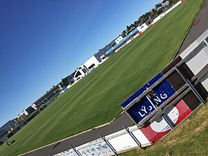
Keflavíkurvöllur
Multi-use stadium in Iceland
Distance: Approx. 9072 meters
Latitude and longitude: 63.997997,-22.559224
Keflavíkurvöllur (Icelandic pronunciation: [ˈcʰɛplaˌviːkʏrˌvœtlʏr̥]) is a multi-use stadium in Keflavík, Iceland. It is currently used mostly for football matches. Keflavík Football Club plays there.

Sandgerði
Town in Southern Peninsula, Iceland
Distance: Approx. 3604 meters
Latitude and longitude: 64.05305556,-22.70416667
Sandgerðisbær (Icelandic pronunciation: [ˈsantˌcɛrðɪsˌpaiːr̥]) is a town in southwestern Iceland on the Southern Peninsula. It is part of the municipality of Suðurnesjabær, formed in 2018 when it merged with Garður. Sandgerði began to develop as a fishing village in the second half of the nineteenth century as motorboats replaced row boats in the industry.
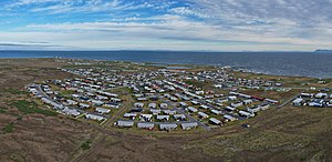
Garður
Town in Southern Peninsula, Iceland
Distance: Approx. 646 meters
Latitude and longitude: 64.06666667,-22.63333333
Garður (Icelandic pronunciation: [ˈkarðʏr̥] ) is a town in southwestern Iceland on the Southern Peninsula, bordered by the Faxaflói Bay. It is part of the municipality of Suðurnesjabær, formed in 2018 when it merged with Sandgerði. The town's name means garden or yard, after one of the many earthen walls once erected on the boundaries between local properties.
Keflavik Air Station
Distance: Approx. 5520 meters
Latitude and longitude: 64.02166667,-22.65583333
Keflavik Air Station (NATO ID: H-1A) is a now-closed United States Air Force General Surveillance Radar station. It is located 3 miles (4.8 km) north-northwest of Naval Air Station Keflavik, Iceland. It was closed on 28 June 2006 as part of the closure of United States military facilities in Iceland.
Rockville Air Station (Iceland)
Former US Air Force radar station
Distance: Approx. 4009 meters
Latitude and longitude: 64.03527778,-22.65444444
Rockville Air Station (ADC/NATO ID: H-1) is a closed United States Air Force General Surveillance Radar station. It is located 2.9 miles (4.7 km) west-northwest of Naval Air Station Keflavik, Iceland. It was closed on in 1998.

Uppspretta
Toyist artwork in Keflavík, Iceland
Distance: Approx. 8710 meters
Latitude and longitude: 63.999547,-22.569056
Uppspretta is the name of a Toyist artwork situated in the Icelandic town of Keflavík. In 2013, a neglected water tower being nine meters in height and thirty-six meters in circumference, was transformed into an object of art. The painting shows the story of a puffin named Uppspretta.
Njarðtaksvöllurinn
Distance: Approx. 9739 meters
Latitude and longitude: 63.9906,-22.5631
Njarðtaksvöllurinn is a multi-use stadium in Njarðvík, Iceland. It is currently used mostly for football matches and is the home stadium of Njarðvík FC. Its capacity is around 1400.
SS Godafoss
Distance: Approx. 8699 meters
Latitude and longitude: 64.13333333,-22.75
SS Godafoss was an Icelandic cargo ship that was torpedoed by the German submarine U-300 just off Reykjanes 4 nautical miles (7.4 km) northwest of Gardur, Iceland (64°08′N 22°45′W), while she was travelling from New York, United States to Reykjavík, Iceland.
Weather in this IP's area
broken clouds
6 Celsius
5 Celsius
6 Celsius
8 Celsius
1001 hPa
87 %
1001 hPa
1000 hPa
10000 meters
2.57 m/s
280 degree
75 %
06:34:45
20:21:52