Country:
 Poland
Region:
City:
Latitude and Longitude:
Time Zone:
Postal Code:
IP information under different IP Channel
ip-api
Country
Region
City
ASN
Time Zone
ISP
Blacklist
Proxy
Latitude
Longitude
Postal
Route
IPinfo
Country
Region
City
ASN
Time Zone
ISP
Blacklist
Proxy
Latitude
Longitude
Postal
Route
MaxMind
Country
Region
City
ASN
Time Zone
ISP
Blacklist
Proxy
Latitude
Longitude
Postal
Route
Luminati
Country
PLRegion
14
City
warsaw
ASN
Time Zone
Europe/Warsaw
ISP
Netia SA
Latitude
Longitude
Postal
db-ip
Country
Region
City
ASN
Time Zone
ISP
Blacklist
Proxy
Latitude
Longitude
Postal
Route
ipdata
Country
Region
City
ASN
Time Zone
ISP
Blacklist
Proxy
Latitude
Longitude
Postal
Route
Popular places and events near this IP address

Maria Skłodowska-Curie National Research Institute of Oncology
Hospital in Masovian Voivodeship, Poland
Distance: Approx. 1579 meters
Latitude and longitude: 52.1475,21.0325
The Maria Sklodowska-Curie National Research Institute of Oncology (Polish: Narodowy Instytut Onkologii im. Marii Skłodowskiej-Curie – Państwowy Instytut Badawczy, until 2020 Maria Skłodowska-Curie Institute of Oncology, Polish: Centrum Onkologii–Instytut im. Marii Skłodowskiej-Curie) is a specialized research institute and hospital of the Polish Ministry of Health.

Puławska Street, Warsaw
Distance: Approx. 785 meters
Latitude and longitude: 52.15916667,21.01777778
Puławska Street (Polish: Ulica Puławska) is one of the main streets of the city of Warsaw, Poland. It links the southern City Centre and the southern boroughs of Mokotów and Ursynów with the suburb of Piaseczno. The street is named after the city of Puławy, Poland.

Ursynów metro station
Warsaw metro station
Distance: Approx. 1475 meters
Latitude and longitude: 52.16194444,21.02777778
Metro Ursynów is a station on Line M1 of the Warsaw Metro, located in the Ursynów district in south Warsaw, at the junction of Aleja KEN and Surowieckiego Street. The station was opened on 7 April 1995 as part of the inaugural stretch of the Warsaw Metro, between Kabaty and Politechnika.

North Ursynów
Neighbourhood in Warsaw, Poland
Distance: Approx. 1297 meters
Latitude and longitude: 52.15888889,21.02805556
North Ursynów is a neighbourhood, and a City Information System area, located in Warsaw, Poland, within the district of Ursynów. North Ursynów mostly consists of highrise multifamily housing. Two largest neighbourhoods, which make up most of its area, are Jary, and Stokłosy.
Jary, Warsaw
Neighbourhood in Warsaw, Poland
Distance: Approx. 1087 meters
Latitude and longitude: 52.15888889,21.02444444
Jary is a neighbourhood in Warsaw, Poland, located within the district of Ursynów, in the City Information System of North Ursynów. By the 1930s, within the modern boundaries of North Ursynów was located a small settlement of Imielin Nowy. In 1951, the area was incorporated into the city of Warsaw Jary was constructed between 1971 and 1977, together with Stokłosy, as neighbourhoods of the North Ursynów residential area.

Wyczółki, Warsaw
Neighbourhood in Warsaw, Poland
Distance: Approx. 1042 meters
Latitude and longitude: 52.15888889,20.99916667
Wyczółki is a neighbourhood, and a City Information System area, located in Warsaw, Poland, within the district of Ursynów. It is a mixed area, consisting of residencial zones, as well as business office complexes and storage warehouses. The oldest known records of Wyczółki, then a small village inhabited by petty nobility, come from 1483.

Grabów, Warsaw
Neighbourhood in Warsaw, Poland
Distance: Approx. 978 meters
Latitude and longitude: 52.145,21.01611111
Grabów is a neighbourhood, and a City Information System area, located in Warsaw, Poland, within the district of Ursynów. It consists mostly of the low-rise residential buildings. The area conists of two historical neighbourhoods of single-family detached homes, Grabów to the northeast, and Krasnowola in the southwest.

Krasnowola
Neighbourhood in Warsaw, Poland
Distance: Approx. 1464 meters
Latitude and longitude: 52.1425,20.99916667
Krasnowola is a neighbourhood in Warsaw, Poland, located within the district of Ursynów, in the City Information System area of Grabów. It is centred around Krasnowolska Street, and mostly consists of single-family detached homes. The village of Krasnowola was founded in the 19th century, to the southeast of Grabówek In the second half of the century, there was constructed the Krasnowola Manor House In 1951 the area was incorporated into Warsaw.

Stary Imielin
Neighbourhood in Warsaw, Poland
Distance: Approx. 1333 meters
Latitude and longitude: 52.14916667,21.02972222
Stary Imielin, also known as West Ursynów, is a neighbourhood, and a City Information System area, located in Warsaw, Poland, within the district of Ursynów. It is a residencial area, mostly consists of the multifamily housing. There are also located numerous medical facilities, including Maria Skłodowska-Curie National Research Institute of Oncology, the Institute of Hematology and Transfusion Medicine, and the Southern Hospital.
Grabówek, Warsaw
Neighbourhood in Warsaw, Poland
Distance: Approx. 1427 meters
Latitude and longitude: 52.14055556,21.01361111
Grabówek is a neighbourhood in Warsaw, Poland, located within the district of Ursynów, in the City Information System area of Grabów. It is a residencial area with single-family housing. It was founded in the 19th century, and was incorporated into Warsaw in 1951.
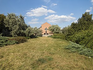
Roman Kozłowski Park
Urban park in Warsaw, Poland
Distance: Approx. 1428 meters
Latitude and longitude: 52.16416667,21.0225
The Roman Kozłowski Park is an urban park in Warsaw, Poland, located in the district of Ursynów, between Koński Jar Street, Nutki Street, Rzymowskiego Street, and Puszczyka Street. It was opened in 1977.
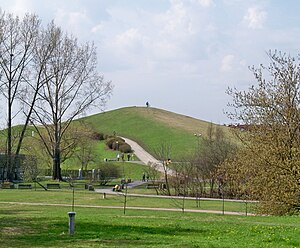
John Paul II Park (Warsaw)
Urban park in Warsaw, Poland
Distance: Approx. 1216 meters
Latitude and longitude: 52.15611111,21.02861111
The John Paul II Park (Polish: Park im. Jana Pawła II) is an urban park in Warsaw, Poland, within the district of Ursynów, between Romera Street and Molodyjna Street. It was opened in 2000.
Weather in this IP's area
clear sky
19 Celsius
19 Celsius
17 Celsius
20 Celsius
1020 hPa
60 %
1020 hPa
1008 hPa
10000 meters
5.14 m/s
60 degree
06:12:31
18:49:08