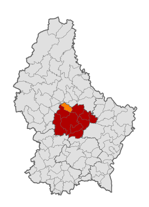
Country:
 Luxembourg
Region:
City:
Latitude and Longitude:
Time Zone:
Postal Code:
IP information under different IP Channel
ip-api
Country
Region
City
ASN
Time Zone
ISP
Blacklist
Proxy
Latitude
Longitude
Postal
Route
IPinfo
Country
Region
City
ASN
Time Zone
ISP
Blacklist
Proxy
Latitude
Longitude
Postal
Route
MaxMind
Country
Region
City
ASN
Time Zone
ISP
Blacklist
Proxy
Latitude
Longitude
Postal
Route
Luminati
Country
LUASN
Time Zone
Europe/Luxembourg
ISP
Ses Astra S.A.
Latitude
Longitude
Postal
db-ip
Country
Region
City
ASN
Time Zone
ISP
Blacklist
Proxy
Latitude
Longitude
Postal
Route
ipdata
Country
Region
City
ASN
Time Zone
ISP
Blacklist
Proxy
Latitude
Longitude
Postal
Route
Popular places and events near this IP address

Luxembourg
Country in Western Europe
Distance: Approx. 178 meters
Latitude and longitude: 49.81444444,6.13166667
Luxembourg ( LUK-səm-burg; Luxembourgish: Lëtzebuerg [ˈlətsəbuəɕ] ; German: Luxemburg [ˈlʊksm̩bʊʁk] ; French: Luxembourg [lyksɑ̃buʁ] ), officially the Grand Duchy of Luxembourg, is a small landlocked country in Western Europe. It is bordered by Belgium to the west and north, Germany to the east, and France to the south. Its capital and most populous city, Luxembourg City, is one of the four institutional seats of the European Union (together with Brussels, Frankfurt, and Strasbourg) and the seat of several EU institutions, notably the Court of Justice of the European Union, the highest judicial authority.
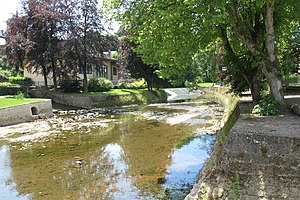
Attert (river)
River in Belgium, Luxembourg
Distance: Approx. 2404 meters
Latitude and longitude: 49.814933,6.09612
The Attert (French pronunciation: [atɛʁt], German pronunciation: [ˈatɐt]; Luxembourgish: Atert) is a river flowing through Belgium and Luxembourg, left tributary of the Alzette. Its length is 38 kilometres (24 mi), of which 32 kilometres (20 mi) are in Luxembourg and 6 kilometres (4 mi) in Belgium. Its source is in Nobressart, north-west of Arlon, in the Belgian province Luxembourg.
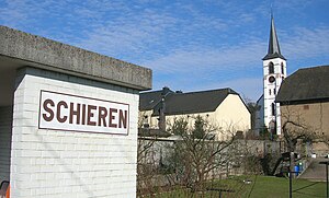
Schieren
Commune in Diekirch, Luxembourg
Distance: Approx. 2920 meters
Latitude and longitude: 49.8333,6.1
Schieren is a commune and town in central Luxembourg. It is part of the canton of Diekirch. Schieren is served by a railway station, and the commune encompasses the hamlet of Birtrange, which contains Birtrange castle.
Colmar-Berg
Commune in Mersch, Luxembourg
Distance: Approx. 2372 meters
Latitude and longitude: 49.8111,6.0972
Colmar-Berg (Luxembourgish: Colmer-Bierg, German: Colmar-Berg) is a commune and town in central Luxembourg, in the canton of Mersch. It is situated at the confluence of the rivers Attert and Alzette. Colmar-Berg is the site of the Grand Duke of Luxembourg's principal residence, Berg Castle.

Berg, Luxembourg
Distance: Approx. 2918 meters
Latitude and longitude: 49.814,6.089
Berg (Luxembourgish: Bierg) is a village in the commune of Betzdorf, in eastern Luxembourg. As of 2024, the village had a population of 351. It is the administrative centre of the commune.

Berg Castle
Castle in Colmar-Berg, Luxembourg
Distance: Approx. 3065 meters
Latitude and longitude: 49.81416667,6.08694444
Berg Castle (Luxembourgish: Schlass Bierg, pronounced [ˈʃlɑs ˈbiːɐ̯ɕ]; French: Château de Berg; German: Schloss Berg) is the principal residence of the Grand Duke of Luxembourg. It is situated in the town of Colmar-Berg, in central Luxembourg, near the confluence of the Alzette and the Attert, two of Luxembourg's most important rivers.

Cruchten
Distance: Approx. 1724 meters
Latitude and longitude: 49.8,6.13333333
Cruchten (Luxembourgish: Kruuchten) is a small village in the commune of Nommern, in central Luxembourg. As of 2024, the village has a population of 679. Cruchten is served by a railway station.
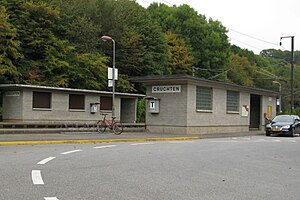
Cruchten railway station
Railway station in Luxembourg
Distance: Approx. 2209 meters
Latitude and longitude: 49.79638889,6.12027778
Cruchten railway station (Luxembourgish: Gare Kruuchten, French: Gare de Cruchten, German: Bahnhof Kruchten) is a railway station serving the town of Cruchten, in the commune of Nommern, in central Luxembourg. It is operated by Chemins de Fer Luxembourgeois, the state-owned railway company. The station is situated on Line 10, which connects Luxembourg City to the centre and north of the country.

Colmar-Berg railway station
Railway station in Luxembourg
Distance: Approx. 2005 meters
Latitude and longitude: 49.815,6.10166667
Colmar-Berg railway station (Luxembourgish: Gare Kolmer-Bierg, French: Gare de Colmar-Berg, German: Bahnhof Colmar-Berg) is a railway station serving Colmar-Berg, in central Luxembourg. It is operated by Chemins de Fer Luxembourgeois, the state-owned railway company. The station is situated on Line 10, which connects Luxembourg City to the centre and north of the country.
Schieren railway station
Railway station in Luxembourg
Distance: Approx. 2005 meters
Latitude and longitude: 49.815,6.10166667
Schieren railway station (Luxembourgish: Gare Schiren, French: Gare de Schieren, German: Bahnhof Schieren) is a railway station serving Schieren, in central Luxembourg. It is operated by Chemins de Fer Luxembourgeois, the state-owned railway company. The station is situated on Line 10, which connects Luxembourg City to the centre and north of the country.
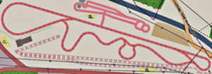
Circuit Goodyear
Motor racing circuit in Colmar-Berg, Luxembourg
Distance: Approx. 2959 meters
Latitude and longitude: 49.795,6.103
The Circuit Goodyear is a motor racing circuit in Colmar-Berg, Luxembourg. The circuit is owned and used as a testing venue by the Goodyear Tire and Rubber Company.

Birtrange Castle
Castle in Luxembourg
Distance: Approx. 3159 meters
Latitude and longitude: 49.8264,6.0891
Birtrange Castle (Luxembourgish: Schlass Biertreng; French: Château de Birtrange) is a castle near Schieren, Luxembourg. The castle was constructed in the 13th century by Gaspard-Florent de Breiderbach, and built in an English Gothic style. It was acquired in 1813 by the De Blochhausen family, who held the castle until 1935, when it came to be under the control of the De Broqueville family.
Weather in this IP's area
broken clouds
16 Celsius
16 Celsius
14 Celsius
17 Celsius
1012 hPa
93 %
1012 hPa
976 hPa
10000 meters
4.23 m/s
10.87 m/s
227 degree
69 %
07:01:41
20:04:49