213.163.243.15 - IP Lookup: Free IP Address Lookup, Postal Code Lookup, IP Location Lookup, IP ASN, Public IP
Country:
Region:
City:
Location:
Time Zone:
Postal Code:
IP information under different IP Channel
ip-api
Country
Region
City
ASN
Time Zone
ISP
Blacklist
Proxy
Latitude
Longitude
Postal
Route
Luminati
Country
Region
8
City
feldkirch
ASN
Time Zone
Europe/Vienna
ISP
iPlace Internet & Network Services GmbH
Latitude
Longitude
Postal
IPinfo
Country
Region
City
ASN
Time Zone
ISP
Blacklist
Proxy
Latitude
Longitude
Postal
Route
IP2Location
213.163.243.15Country
Region
vorarlberg
City
feldkirch
Time Zone
Europe/Vienna
ISP
Language
User-Agent
Latitude
Longitude
Postal
db-ip
Country
Region
City
ASN
Time Zone
ISP
Blacklist
Proxy
Latitude
Longitude
Postal
Route
ipdata
Country
Region
City
ASN
Time Zone
ISP
Blacklist
Proxy
Latitude
Longitude
Postal
Route
Popular places and events near this IP address

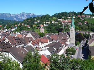
Feldkirch, Vorarlberg
Town in Vorarlberg, Austria
Distance: Approx. 566 meters
Latitude and longitude: 47.23805556,9.59833333
Feldkirch (German pronunciation: [ˈfɛltkɪʁç] ) is a town in the western Austrian state of Vorarlberg, bordering on Switzerland and Liechtenstein. It is the administrative centre of the Feldkirch district. After Dornbirn, it is the second most populous town in Vorarlberg.

Vorarlberghalle
Distance: Approx. 1247 meters
Latitude and longitude: 47.24066667,9.58783611
Vorarlberghalle is an indoor sporting arena located in Feldkirch, Austria. The capacity of the arena is 5,200 people (2000) and was built in 1977.

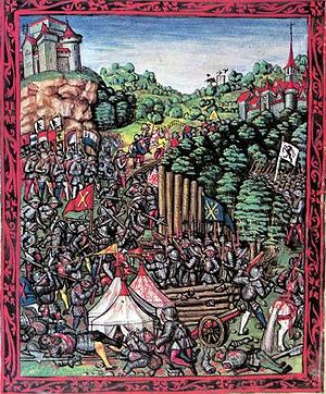
Battle of Frastanz
Battle during the Swabian War
Distance: Approx. 2101 meters
Latitude and longitude: 47.22,9.62
The Battle of Frastanz between an army of the Old Swiss Confederacy and the troops of King Maximilian I of the Holy Roman Empire took place on 20 April 1499. In one of the many raids of the Swabian War, an expedition of Habsburg troops had plundered some villages in the Swiss Confederacy, who responded by sending an army to Vorarlberg. At Frastanz, a few kilometers south-east of Feldkirch, the Habsburg troops had blocked the entry to the Montafon valley with a strong wooden fortification called a Letzi.

Frastanz
Municipality in Vorarlberg, Austria
Distance: Approx. 2101 meters
Latitude and longitude: 47.22,9.62
Frastanz is a market town in the district of Feldkirch in the westernmost Austrian state of Vorarlberg. In former times it was known for its production of tobacco.

Samina (river)
River of Liechtenstein and Austria
Distance: Approx. 2218 meters
Latitude and longitude: 47.2253,9.627
The Samina (also: Saminabach) is a whitewater river of Liechtenstein and Austria. It is a tributary of the Ill. The Samina originates in Liechtenstein.

Schattenburg
Castle, museum and restaurant in Feldkirch, Vorarlberg, Austria
Distance: Approx. 369 meters
Latitude and longitude: 47.23638889,9.59944444
Schattenburg is a castle, museum, and restaurant in Feldkirch, Vorarlberg (Austria). Schattenburg is 480 metres (1,570 ft) above sea level.[1]. Its name is assumedly derived from the word stem "schatte, schad" meaning "protection, shield".

Göfis
Municipality in Vorarlberg, Austria
Distance: Approx. 2499 meters
Latitude and longitude: 47.23305556,9.63305556
Göfis is a municipality in the district of Feldkirch in the Austrian state of Vorarlberg.

Roman Catholic Diocese of Feldkirch
Catholic ecclesiastical territory
Distance: Approx. 573 meters
Latitude and longitude: 47.2381,9.5982
The Diocese of Feldkirch (Latin: Dioecesis Campitemplensis) is a Latin Church diocese located in the city of Feldkirch, Vorarlberg, in the ecclesiastical province of Salzburg in Austria.

Feldkirch railway station
Railway station in Vorarlberg, Austria
Distance: Approx. 946 meters
Latitude and longitude: 47.24111111,9.60416667
Feldkirch railway station (German: Bahnhof Feldkirch) serves the city of Feldkirch, in the Feldkirch district of the Austrian federal state of Vorarlberg. Opened in 1872, it forms the junction between the Vorarlberg railway and the Feldkirch–Buchs railway. The station, which is owned and operated by the Austrian Federal Railways (ÖBB), is the largest in Feldkirch.
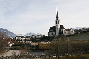
Feldkirch Cathedral
Church in Feldkirch, Austria
Distance: Approx. 573 meters
Latitude and longitude: 47.2381,9.5982
Feldkirch Cathedral (German: Dompfarrkirche St. Nikolaus) is a Roman Catholic cathedral dedicated to Saint Nicholas in the city of Feldkirch, Vorarlberg, Austria. It is part of the old town and is the largest Gothic church in Vorarlberg.
Feldkirch Sickhouse
Building in Feldkirch, Austria
Distance: Approx. 2108 meters
Latitude and longitude: 47.249945,9.612752
Feldkirch Sickhouse (Siechenhaus), Feldkirch, Vorarlberg, Austria, is listed an Austrian monument of cultural significance. The group of two buildings was erected in the late 16th or early 17th century. Far outside the city of Feldkirch a leper house was founded in the 14th century.

Tisis railway station
Railway station in Feldkirch, Vorarlberg
Distance: Approx. 1978 meters
Latitude and longitude: 47.227085,9.575385
Tisis railway station is a railway station in the Tisis district of the town of Feldkirch in the westernmost Austrian Federal State of Vorarlberg. The station is located on the Feldkirch–Buchs railway line near the border to the Principality of Liechtenstein. It is served by regional trains only.
Weather in this IP's area
scattered clouds
-6 Celsius
-6 Celsius
-8 Celsius
-4 Celsius
1040 hPa
79 %
1040 hPa
915 hPa
10000 meters
0.89 m/s
0.89 m/s
33 degree
35 %

