Country:
 Russian Federation
Region:
City:
Latitude and Longitude:
Time Zone:
Postal Code:
IP information under different IP Channel
ip-api
Country
Region
City
ASN
Time Zone
ISP
Blacklist
Proxy
Latitude
Longitude
Postal
Route
IPinfo
Country
Region
City
ASN
Time Zone
ISP
Blacklist
Proxy
Latitude
Longitude
Postal
Route
MaxMind
Country
Region
City
ASN
Time Zone
ISP
Blacklist
Proxy
Latitude
Longitude
Postal
Route
Luminati
Country
RUASN
Time Zone
Europe/Moscow
ISP
Rial Com JSC
Latitude
Longitude
Postal
db-ip
Country
Region
City
ASN
Time Zone
ISP
Blacklist
Proxy
Latitude
Longitude
Postal
Route
ipdata
Country
Region
City
ASN
Time Zone
ISP
Blacklist
Proxy
Latitude
Longitude
Postal
Route
Popular places and events near this IP address
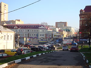
Podolsk
City in Moscow Oblast, Russia
Distance: Approx. 757 meters
Latitude and longitude: 55.43111111,37.54555556
Podolsk (Russian: Подольск, IPA: [pɐˈdolʲsk]) is an industrial city, center of Podolsk Urban Okrug, Moscow Oblast, Russia, located on the Pakhra River (a tributary of the Moskva River).
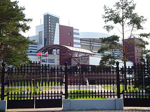
Vityaz Ice Palace
Distance: Approx. 2595 meters
Latitude and longitude: 55.420275,37.51577778
Vityaz Ice Palace is an indoor sporting arena located in Podolsk, Russia. The capacity of the arena is 5,500 and was built in 2000. The home games of Vityaz Podolsk and its junior team : Russkie Vityazi are played in the arena.

Klimovsk
Town in Moscow Oblast, Russia
Distance: Approx. 6856 meters
Latitude and longitude: 55.36666667,37.53333333
Klimovsk (Russian: Климовск, IPA: [ˈklʲiməfsk]) is a city in Podolsk Urban Okrug, Moscow Oblast, Russia, located 55 kilometers (34 mi) south of Moscow and 8 kilometers (5.0 mi) south of Podolsk. Population: 56,186 (2010 Census); 55,644 (2002 Census); 56,720 (1989 Soviet census).

Shcherbinka
Town in Moscow, Russia
Distance: Approx. 8159 meters
Latitude and longitude: 55.5,37.56666667
Shcherbinka (‹See Tfd›Russian: Ще́рбинка) is a town, formerly in Moscow Oblast, Russia, and since July 1, 2012 a federal city subject (settlement) of Moscow, Russia. It is located 37 kilometers (23 mi) south of the center of Moscow. Population: 32,450 (2010 Census); 28,043 (2002 Census); 28,011 (1989 Soviet census).

Klimovsk Specialized Ammunition Plant
Distance: Approx. 5402 meters
Latitude and longitude: 55.37861111,37.54861111
Klimovsk Specialized Ammunition Plant (CJSC KSAP) (‹See Tfd›Russian: Климовский специализированный патронный завод, romanized: Klimovskiy spetsializirovannyy patronnyy zavod) is an ammunition enterprise located in Russian town Klimovsk near Podolsk in the Moscow region. 7.62×39mm cartridges and wide variety of other service cartridges for various Russian handguns are produced.
Central Archives of the Russian Ministry of Defence
Distance: Approx. 2759 meters
Latitude and longitude: 55.42425,37.51169444
The Central Archives of the Ministry of Defence of the Russian Federation (‹See Tfd›Russian: Центральный архив Министерства обороны Российской Федерации (ЦАМО РФ); TsAMO RF) are located in Podolsk, just south of the city of Moscow. As a departmental archive of Russia, it stores documents of different staffs and offices, associations and formations, units, institutions and military academies of the Soviet Defence Ministry from 1941 until the end of the 1980s. It comes under the command of the Rear Services of the Armed Forces of Russia.

Podolsky District
District in Moscow Oblast, Russia
Distance: Approx. 1195 meters
Latitude and longitude: 55.41666667,37.55
Podolsky District (‹See Tfd›Russian: Подо́льский райо́н) is an abolished administrative and municipal district (raion), one of the thirty-six in Moscow Oblast, Russia. It was located in the southwest of the oblast just south of the federal city of Moscow. The area of the district was 281.45 square kilometers (108.67 sq mi).

2013 Oznobishino bus crash
Distance: Approx. 8066 meters
Latitude and longitude: 55.3974,37.4386
The 2013 Oznobishino bus crash occurred on 13 July 2013 at about 13:00 local time (09:00 UTC) when a bus carrying 64 people was hit by a KAMAZ truck in Oznobishino, Moscow Oblast, about 25 miles (40 km) southwest of Moscow. At least 18 people died and another 60 people were injured, with 12 of them in a critical condition. 14 of the victims died at the scene and another four died in hospital.

Russian New University
University in Moscow, Russia
Distance: Approx. 5714 meters
Latitude and longitude: 55.3766,37.538
Russian New University (RosNOU) (Russian: Российский новый университет, abbreviated РосНОУ) is a Russian non-profit institution of higher education.

Ostafyevo railway station
Railway station in Moscow, Russia
Distance: Approx. 6546 meters
Latitude and longitude: 55.4858,37.5552
Ostafyevo is a railway station of Line D2 of the Moscow Central Diameters in Moscow. It was opened in 2020.

Podolsk railway station
Railway station in Moscow Oblast, Russia
Distance: Approx. 835 meters
Latitude and longitude: 55.4317,37.5654
Podolsk is a railway station of Line D2 of the Moscow Central Diameters in Moscow Oblast. It was opened in 1865 and rebuilt in 2020.
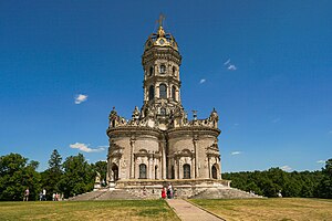
Znamenskaya Church (Dubrovitsy)
Church in Dubrovitsy, Moscow Oblast, Russia
Distance: Approx. 4150 meters
Latitude and longitude: 55.44129722,37.49440833
The Church of the Theotokos of the Sign (Dubrovitsy), or The Church of the Holy Sign of the Mother of God in Dubrovitsy, (‹See Tfd›Russian: Церковь Зна́мения Пресвятой Богоро́дицы в Дубровицах) is a Russian Orthodox church in the village of Dubrovitsy, Podolsk Urban Okrug, Moscow Oblast, Russia. Dubrovitsy is located about 36 km South of Moscow (16 km from the Moscow Ring Road; along the highway Podolsk-Dubrovitsy 6 km). The Dubrovitsy Estate used to belong to the noble families of Morozov, Golitsyn and Dmitriev-Mamonov.
Weather in this IP's area
broken clouds
8 Celsius
6 Celsius
7 Celsius
8 Celsius
1020 hPa
85 %
1020 hPa
1000 hPa
10000 meters
2.7 m/s
5.62 m/s
70 degree
81 %
06:42:23
17:53:02