213.155.176.126 - IP Lookup: Free IP Address Lookup, Postal Code Lookup, IP Location Lookup, IP ASN, Public IP
Country:
Region:
City:
Location:
Time Zone:
Postal Code:
IP information under different IP Channel
ip-api
Country
Region
City
ASN
Time Zone
ISP
Blacklist
Proxy
Latitude
Longitude
Postal
Route
Luminati
Country
Region
32
City
goleniow
ASN
Time Zone
Europe/Warsaw
ISP
Speedmedia Sp z o.o.
Latitude
Longitude
Postal
IPinfo
Country
Region
City
ASN
Time Zone
ISP
Blacklist
Proxy
Latitude
Longitude
Postal
Route
IP2Location
213.155.176.126Country
Region
zachodniopomorskie
City
goleniow
Time Zone
Europe/Warsaw
ISP
Language
User-Agent
Latitude
Longitude
Postal
db-ip
Country
Region
City
ASN
Time Zone
ISP
Blacklist
Proxy
Latitude
Longitude
Postal
Route
ipdata
Country
Region
City
ASN
Time Zone
ISP
Blacklist
Proxy
Latitude
Longitude
Postal
Route
Popular places and events near this IP address

Goleniów
Town in Pomerania, Poland
Distance: Approx. 44 meters
Latitude and longitude: 53.56361111,14.82805556
Goleniów [ɡɔˈlɛɲuf] (Kashubian: Gòłonóg; German: Gollnow) is a town in Pomerania, northwestern Poland with 22,844 inhabitants as of 2011. It is the capital of Goleniów County in West Pomeranian Voivodeship. The town's area is 12.5 square kilometres (4.8 sq mi), and its geographical position is 53°33'N, 14°49'E. It is situated in the centre of Goleniowska Forest on Goleniów Plain, near main roads numbers 3 and 6.

Helenów (Goleniów)
Distance: Approx. 3250 meters
Latitude and longitude: 53.54416667,14.86472222
Helenów, known as Helgenfeld until 1945, is a neighborhood in Goleniów, in Goleniów County, Poland. It is situated two kilometres south of the centre of town, near the road leading to Stargard, by the river Wiśniówka, on the edge of Równina Goleniowska (Goleniów Plain) and Równina Nowogardzka (Nowogard Plain), and bordered on the west by the forests of Puszcza Goleniowska (Goleniów Forest). The village of Helenów was linked with the town in 1954.

Goleniów County
County in West Pomeranian Voivodeship, Poland
Distance: Approx. 1734 meters
Latitude and longitude: 53.55,14.81666667
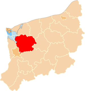
Goleniów County (Polish: powiat goleniowski) is a unit of territorial administration and local government (powiat) in West Pomeranian Voivodeship, north-western Poland. It came into being on January 1, 1999, as a result of the Polish local government reforms passed in 1998. Its administrative seat and largest town is Goleniów, which lies 22 kilometres (14 mi) north-east of the regional capital Szczecin.
Gmina Goleniów
Gmina in West Pomeranian Voivodeship, Poland
Distance: Approx. 1734 meters
Latitude and longitude: 53.55,14.81666667
Gmina Goleniów is an urban-rural gmina (administrative district) in Goleniów County, West Pomeranian Voivodeship, in north-western Poland. Its seat is the town of Goleniów, which lies approximately 22 kilometres (14 mi) north-east of the regional capital Szczecin. The gmina covers an area of 443.06 square kilometres (171.1 sq mi), and as of 2006 its total population is 33,137 (out of which the population of Goleniów amounts to 22,448, and the population of the rural part of the gmina is 10,689).
Domastryjewo
Village in West Pomeranian Voivodeship, Poland
Distance: Approx. 2308 meters
Latitude and longitude: 53.56333333,14.79361111
Domastryjewo [dɔmastrɨˈjɛvɔ] is a village in the administrative district of Gmina Goleniów, within Goleniów County, West Pomeranian Voivodeship, in north-western Poland. For the history of the region, see History of Pomerania.
Łozienica
Village in West Pomeranian Voivodeship, Poland
Distance: Approx. 3951 meters
Latitude and longitude: 53.53888889,14.78611111
Łozienica [wɔʑɛˈnit͡sa] (German: Neuhof) is a village in the administrative district of Gmina Goleniów, within Goleniów County, West Pomeranian Voivodeship, in north-western Poland. It lies approximately 4 kilometres (2 mi) west of Goleniów and 20 km (12 mi) north-east of the regional capital Szczecin. For the history of the region, see History of Pomerania.

Marszewo, Goleniów County
Village in West Pomeranian Voivodeship, Poland
Distance: Approx. 4229 meters
Latitude and longitude: 53.57083333,14.89138889
Marszewo [marˈʂɛvɔ] (German: Marsdorf) is a village in the administrative district of Gmina Goleniów, within Goleniów County, West Pomeranian Voivodeship, in north-western Poland. It lies approximately 6 kilometres (4 mi) north-east of Goleniów and 27 km (17 mi) north-east of the regional capital Szczecin. It is located in the historic region of Pomerania.
Żdżary, West Pomeranian Voivodeship
Village in West Pomeranian Voivodeship, Poland
Distance: Approx. 3174 meters
Latitude and longitude: 53.58416667,14.79472222
Żdżary [ˈʐd͡ʐarɨ] (German: Eichberg) is a village in the administrative district of Gmina Goleniów, within Goleniów County, West Pomeranian Voivodeship, in north-western Poland. It lies approximately 5 kilometres (3 mi) north of Goleniów and 24 km (15 mi) north-east of the regional capital Szczecin. For the history of the region, see History of Pomerania.
Żółwia
Village in West Pomeranian Voivodeship, Poland
Distance: Approx. 2634 meters
Latitude and longitude: 53.55611111,14.86611111
Żółwia [ˈʐuu̯vja] (German: Gollnow-Papiermühle) is a village in the administrative district of Gmina Goleniów, within Goleniów County, West Pomeranian Voivodeship, in north-western Poland. For the history of the region, see History of Pomerania.
Żółwia Błoć
Village in West Pomeranian Voivodeship, Poland
Distance: Approx. 4265 meters
Latitude and longitude: 53.59666667,14.86194444
Żółwia Błoć [ˈʐuu̯vja ˈbwɔt͡ɕ] (formerly German: Barfußdorf) is a village in the administrative district of Gmina Goleniów, within Goleniów County, West Pomeranian Voivodeship, in north-western Poland. It lies approximately 6 kilometres (4 mi) north-east of Goleniów and 28 km (17 mi) north-east of the regional capital Szczecin. For the history of the region, see History of Pomerania.
Krzewno, West Pomeranian Voivodeship
Village in West Pomeranian Voivodeship, Poland
Distance: Approx. 1087 meters
Latitude and longitude: 53.55416667,14.82972222
Krzewno [ˈkʂɛvnɔ] (German: Lüttkenheide) is a village in the administrative district of Gmina Goleniów, within Goleniów County, West Pomeranian Voivodeship, in north-western Poland. It lies approximately 1 kilometre (1 mi) north-east of Goleniów and 23 km (14 mi) north-east of the regional capital Szczecin. For the history of the region, see History of Pomerania.

Struga Goleniowska
River in Poland
Distance: Approx. 160 meters
Latitude and longitude: 53.5627,14.82716
Struga Goleniowska is a river of Poland, a tributary of the Ina that meets the Ina at the town of Goleniów.
Weather in this IP's area
light rain
7 Celsius
3 Celsius
6 Celsius
8 Celsius
1000 hPa
70 %
1000 hPa
999 hPa
10000 meters
8.23 m/s
14.4 m/s
210 degree
75 %
