Country:
 Italy
ItalyRegion:
City:
Latitude and Longitude:
Time Zone:
Postal Code:
IP information under different IP Channel
ip-api
Country
Region
City
ASN
Time Zone
ISP
Blacklist
Proxy
Latitude
Longitude
Postal
Route
IPinfo
Country
Region
City
ASN
Time Zone
ISP
Blacklist
Proxy
Latitude
Longitude
Postal
Route
MaxMind
Country
Region
City
ASN
Time Zone
ISP
Blacklist
Proxy
Latitude
Longitude
Postal
Route
Luminati
Country
ITRegion
45
City
rimini
ASN
Time Zone
Europe/Rome
ISP
Made Network Srl
Latitude
Longitude
Postal
db-ip
Country
Region
City
ASN
Time Zone
ISP
Blacklist
Proxy
Latitude
Longitude
Postal
Route
ipdata
Country
Region
City
ASN
Time Zone
ISP
Blacklist
Proxy
Latitude
Longitude
Postal
Route
Popular places and events near this IP address

Rimini
City in Emilia-Romagna, Italy
Distance: Approx. 551 meters
Latitude and longitude: 44.05944444,12.56833333
Rimini ( RIM-in-ee; Italian: [ˈriːmini] ; Romagnol: Rémin or Rémne; Latin: Ariminum) is a city in the Emilia-Romagna region of Northern Italy. Sprawling along the Adriatic Sea, Rimini is situated at a strategically-important north-south passage along the coast at the southern tip of the Po Valley. It is one of the most notable seaside resorts in Europe, with a significant domestic and international tourist economy.

Province of Rimini
Province of Italy
Distance: Approx. 524 meters
Latitude and longitude: 44.05,12.56666667
The province of Rimini (Italian: provincia di Rimini) is the southernmost province of the Emilia-Romagna region of Italy. Its capital is the city of Rimini, one of the "seven sisters" of the historical region of Romagna. The province borders the Adriatic Sea to its northeast, the province of Forlì-Cesena to its northwest, the province of Pesaro and Urbino, in the Marche region, to its south and southeast, the independent Republic of San Marino to its south, and the province of Arezzo in Tuscany to its southwest.

Tempio Malatestiano
Cathedral of Rimini, Italy
Distance: Approx. 585 meters
Latitude and longitude: 44.059624,12.570232
The Tempio Malatestiano (Italian: Malatesta Temple) is the unfinished cathedral church of Rimini, Italy. Officially named for St. Francis, it takes the popular name from Sigismondo Pandolfo Malatesta, who commissioned its reconstruction by the famous Renaissance theorist and architect Leon Battista Alberti around 1450.

Battle of Rimini (1944)
Battle during the Italian Campaign of the Second World War
Distance: Approx. 551 meters
Latitude and longitude: 44.05944444,12.56833333
The Battle of Rimini took place between 13 and 21 September 1944 during Operation Olive, the main Allied offensive on the Gothic Line in August and September 1944, part of the Italian Campaign in the Second World War. Rimini, a city on Italy's Adriatic coast, anchored the Rimini Line, a German defensive line which was the third such line of the Gothic Line defences. Rimini, which had been hit previously by 373 air raids, had 1,470,000 rounds fired against it by Allied land forces; by the end of the battle, only 2% of all buildings in the city escaped damage.

Trolleybuses in Rimini
Trolleybus system in Rimini, Italy
Distance: Approx. 524 meters
Latitude and longitude: 44.05,12.56666667
The Rimini trolleybus system (Italian: Rete filoviaria di Rimini) forms part of the public transport network of the Province of Rimini, in the region of Emilia-Romagna, Italy. The network consists of two trolleybus routes that connect the city centres of the coastal comuni of Rimini and Riccione. In operation since 1939 (with subsequent termini modifications), route 11 runs along the principal seafront avenue from Rimini's railway station to Riccione Terme.

Arch of Augustus (Rimini)
Monument in Rimini, Italy
Distance: Approx. 336 meters
Latitude and longitude: 44.05689722,12.57115833
The Arch of Augustus (Italian: Arco d'Augusto, Romagnol: l’Èrc d’Augóst) is a gate set in the former city wall of Rimini, Emilia-Romagna, in the form of an ancient Roman triumphal arch. Built in 27 BC in honour of Augustus, the first Roman emperor, the arch marks the northern end of the Via Flaminia, the road between Ariminum (Rimini) and Rome constructed in 220 BC by Gaius Flaminius. Under Fascist Italy, the adjoining city walls and surrounding buildings were demolished, leaving the Arch of Augustus to stand as an isolated monument.
Sant'Agostino, Rimini
Church in Rimini, Italy
Distance: Approx. 574 meters
Latitude and longitude: 44.05934722,12.56616944
Sant'Agostino is a Romanesque-Gothic-style Roman Catholic church located in Via Cairoli in Rimini, Italy. It is one of the city's oldest extant church buildings.

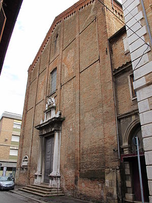
San Bernardino, Rimini
Distance: Approx. 415 meters
Latitude and longitude: 44.0582,12.568
San Bernardino or San Bernardino da Siena is a Baroque-style Roman Catholic church located in vicolo San Bernardino #26 in Rimini, Italy. The church and adjacent convent are now affiliated with Clarissan Order nuns.

Tempietto of Sant'Antonio, Rimini
Distance: Approx. 513 meters
Latitude and longitude: 44.0591,12.56896
The Tempietto di Sant'Antonio is a small, octagonal temple or chapel dedicated to St Anthony of Padua, located in Piazza Tre Martiri of the city of Rimini, region of Emilia Romagna, Italy. A structure was initially built here in 1518, commissioned by Pietro Ricciardelli. The chapel was rebuilt in the Baroque-style after the earthquake of 1672.

San Gaudenzo, Rimini
Distance: Approx. 435 meters
Latitude and longitude: 44.0568,12.5642
San Gaudenzo is a 20th-century Roman Catholic parish church in the Rimini region of Emilia-Romagna Italy. The original parish church was erected in 1856 using designs by Filippo Morolli, but it was destroyed during World War II. The reconstruction, while modeled on the prior church, is a modern reinterpretation, completed in 1950, by the architect Luigi Campanini. Many of the prior artworks were destroyed, including a canvas by Francesco Brici depicting San Gaudenzo.

San Bartolomeo, Rimini
Roman Catholic church in Rimini, Italy
Distance: Approx. 587 meters
Latitude and longitude: 44.05852778,12.57333333
San Bartolomeo, also known as the Santi Bartolomeo e Marino or Santa Rita, is a Baroque-style Roman Catholic church located in Rimini, region of Emilia-Romagna, Italy.

Porta Montanara, Rimini
Monument in Rimini, Italy
Distance: Approx. 412 meters
Latitude and longitude: 44.05729167,12.56521389
Porta Montanara (lit. 'mountain gate'), historically known as Porta Sant'Andrea, is an ancient Roman city gate in the city of Rimini, in the region of Emilia-Romagna, northern Italy. Built after Sulla's civil war in the first century BC, the original construction comprised two arches. The north-facing arch was walled as early as the first or second century AD, and incorporated into a medieval cellar.
Weather in this IP's area
broken clouds
15 Celsius
15 Celsius
14 Celsius
16 Celsius
1012 hPa
85 %
1012 hPa
1012 hPa
10000 meters
1.54 m/s
200 degree
75 %
06:51:27
19:17:00