Country:
 Netherlands
Region:
City:
Latitude and Longitude:
Time Zone:
Postal Code:
IP information under different IP Channel
ip-api
Country
Region
City
ASN
Time Zone
ISP
Blacklist
Proxy
Latitude
Longitude
Postal
Route
IPinfo
Country
Region
City
ASN
Time Zone
ISP
Blacklist
Proxy
Latitude
Longitude
Postal
Route
MaxMind
Country
Region
City
ASN
Time Zone
ISP
Blacklist
Proxy
Latitude
Longitude
Postal
Route
Luminati
Country
NLASN
Time Zone
Europe/Amsterdam
ISP
Global Layer B.V.
Latitude
Longitude
Postal
db-ip
Country
Region
City
ASN
Time Zone
ISP
Blacklist
Proxy
Latitude
Longitude
Postal
Route
ipdata
Country
Region
City
ASN
Time Zone
ISP
Blacklist
Proxy
Latitude
Longitude
Postal
Route
Popular places and events near this IP address

Alblasserdam
Municipality in South Holland, Netherlands
Distance: Approx. 243 meters
Latitude and longitude: 51.87016667,4.66666667
Alblasserdam (Dutch: [ɑlˌblɑsərˈdɑm] ) is a town and municipality in the western Netherlands, in the province of South Holland. It covers an area of 10.06 km2 (3.88 sq mi), of which 1.28 km2 (0.49 sq mi) is water, and has a population of 20,136 as of 2021. Alblasserdam is officially a part of the Drechtsteden region.

Hendrik-Ido-Ambacht
Municipality in South Holland, Netherlands
Distance: Approx. 3396 meters
Latitude and longitude: 51.85,4.63333333
Hendrik-Ido-Ambacht (Dutch: [ˈɦɛndrɪk ˈidoː ˈɑmbɑxt] ) is a town and municipality in the western Netherlands. It is located on the island of IJsselmonde, and borders with Zwijndrecht, Ridderkerk, and the Noord River (with Alblasserdam and Papendrecht on the other side). The jurisdiction of the municipality covers an area of 11.90 km2 (4.59 sq mi) of which 1.29 km2 (0.50 sq mi) is water.

Lekkerkerk
Place in South Holland, Netherlands
Distance: Approx. 3119 meters
Latitude and longitude: 51.89722222,4.68277778
Lekkerkerk is a town and former municipality on the Lek River, now part of the municipality of Krimpenerwaard, South Holland province, the Netherlands. Since 1 January 1985 Lekkerkerk is no longer an independent municipality. Lekkerkerk is mostly an agricultural community with its housing, including attractive 17th, 18th, and 19th century farms, stretched out on the dike along the Lek River.

Oud-Alblas
Village in South Holland, Netherlands
Distance: Approx. 2088 meters
Latitude and longitude: 51.86666667,4.7
Oud-Alblas is a village in the Dutch province of South Holland. It is a part of the municipality of Molenlanden, and lies about 6 km north of Dordrecht. In 2001, the village of Oud-Alblas had 1291 inhabitants.

Oostendam
Village in South Holland, Netherlands
Distance: Approx. 3396 meters
Latitude and longitude: 51.85,4.63333333
Oostendam is a Dutch village. It is located in the municipality of Ridderkerk, within the province of South Holland. The village was first mentioned in 1435 as "totten cleynen Waldammen toe, die men heet op desen voorsz.

The Gorzen
Distance: Approx. 3108 meters
Latitude and longitude: 51.86944444,4.625
The Gorzen is a nature park in the Dutch province of South Holland, located on the eastside of Ridderkerk, between the New Veer and the New harbor. The nature- and recreational park The Gorzen is a former dumpsite with a total area of 40 acres (16 ha). The park was formed in consequences of all kinds of activities and circumstances in a period of half a century shaped in a hillside nature park with a few lakes and brooks.

Noord (river)
River in South Holland, Netherlands
Distance: Approx. 2300 meters
Latitude and longitude: 51.85111111,4.65777778
The Noord ("North") is a short tidal river in the western Netherlands, in the province of South Holland. The Noord starts at the city of Dordrecht where the Beneden Merwede river forks into the Oude Maas and the Noord. It joins the Lek at the city of Ridderkerk and Kinderdijk, and the combined stream is thereafter known as the Nieuwe Maas.
Noordtunnel
Distance: Approx. 1825 meters
Latitude and longitude: 51.8575,4.65361111
The Noord Tunnel is a tunnel under the Noord on the motorway A15 around Rotterdam.
Reformed Church, Nieuw-Lekkerland
Distance: Approx. 2645 meters
Latitude and longitude: 51.8913,4.6882
The Reformed Church in Nieuw-Lekkerland is the biggest and oldest church in Nieuw-Lekkerland, Netherlands. The church was built in 1848, but it is nearly sure that there was a church before. The architect was D. Slingerland.
De Brave Hendrik
Restaurant in Hendrik-Ido-Ambacht, Netherlands
Distance: Approx. 2815 meters
Latitude and longitude: 51.85242778,4.64123889
De Brave Hendrik was a fine dining restaurant in Hendrik-Ido-Ambacht, Netherlands. It was awarded one Michelin star in 1990 and retained that rating until 1996.
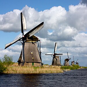
Kinderdijk windmills
UNESCO World Heritage Site
Distance: Approx. 1970 meters
Latitude and longitude: 51.8825,4.64944444
The Kinderdijk windmills are a group of 19 monumental windmills in the Alblasserwaard polder, in the province of South Holland, Netherlands. Most of the mills are part of the village of Kinderdijk in the municipality of Molenlanden, and one mill, De Blokker, is part of the municipality of Alblasserdam. Built in 1738 and 1740, to keep water out of the polder, it is the largest concentration of old windmills in the Netherlands and one of the best-known Dutch tourist sites.

Nederwaard Molen No.1
One of the 19 windmills of Kinderdjik
Distance: Approx. 2657 meters
Latitude and longitude: 51.884694,4.639361
Nederwaard Molen No.1 is one of the Kinderdijk windmills, in the Dutch municipality of Molenlanden. The mill, which dates from 1738, is inhabited and cannot be visited. The owner is the Kinderdijk World Heritage Foundation.
Weather in this IP's area
overcast clouds
16 Celsius
15 Celsius
15 Celsius
16 Celsius
1014 hPa
85 %
1014 hPa
1014 hPa
10000 meters
4.63 m/s
190 degree
100 %
08:13:05
18:39:03