213.149.61.111 - IP Lookup: Free IP Address Lookup, Postal Code Lookup, IP Location Lookup, IP ASN, Public IP
Country:
Region:
City:
Location:
Time Zone:
Postal Code:
ISP:
ASN:
language:
User-Agent:
Proxy IP:
Blacklist:
IP information under different IP Channel
ip-api
Country
Region
City
ASN
Time Zone
ISP
Blacklist
Proxy
Latitude
Longitude
Postal
Route
db-ip
Country
Region
City
ASN
Time Zone
ISP
Blacklist
Proxy
Latitude
Longitude
Postal
Route
IPinfo
Country
Region
City
ASN
Time Zone
ISP
Blacklist
Proxy
Latitude
Longitude
Postal
Route
IP2Location
213.149.61.111Country
Region
dubrovacko-neretvanska zupanija
City
smokvica
Time Zone
Europe/Zagreb
ISP
Language
User-Agent
Latitude
Longitude
Postal
ipdata
Country
Region
City
ASN
Time Zone
ISP
Blacklist
Proxy
Latitude
Longitude
Postal
Route
Popular places and events near this IP address
Korčula
Island of Croatia
Distance: Approx. 2179 meters
Latitude and longitude: 42.95,16.9
Korčula (Croatian: [kɔ̂ːrtʃula] ) is a Croatian island in the Adriatic Sea. It has an area of 279 km2 (108 sq mi), is 46.8 km (29.1 mi) long and on average 7.8 km (4.8 mi) wide, and lies just off the Dalmatian coast. Its 15,522 inhabitants (2011) make it the second most populous Adriatic island after Krk.

Battle of Curzola
1298 naval battle between the fleets of Genoa and Venice
Distance: Approx. 9418 meters
Latitude and longitude: 42.8675,16.97333306
The Battle of Curzola (today Korčula, southern Dalmatia, now in Croatia) was a naval battle fought on 9 September 1298 between the Genoese and Venetian navies. It was a disaster for Venice, a major setback among the many battles fought in the 13th and 14th centuries between Pisa, Genoa, and Venice in a long series of wars for the control of Mediterranean and Levantine trade.
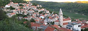
Smokvica, Korčula
Municipality in Dubrovnik-Neretva County, Croatia
Distance: Approx. 184 meters
Latitude and longitude: 42.92916667,16.89527778
Smokvica is a village on the island of Korčula and a municipality in the Dubrovnik-Neretva County in Croatia. Smokvica is located in the centre of the island of Korčula, about 4 kilometers west of Čara, 13 kilometers east of Blato and 4 kilometers north from Brna. It is known as the birthplace of one of the best-known Croatian wines - Pošip.

Brna
Place in Dubrovnik-Neretva County, Croatia
Distance: Approx. 3996 meters
Latitude and longitude: 42.90611111,16.86055556
Brna is a village on the southern coast of the island of Korčula in western Croatia. In the 19th century, Brna served as an overnight base for fishermen from nearby Smokvica, and had a pier that was used for the export of wine. During the 1970s, the village became populated with summer homes for Smokvica residents, and now caters to tourists with a hotel complex and numerous apartments.
Prižba
Village on Korcula, Croatia
Distance: Approx. 8566 meters
Latitude and longitude: 42.9,16.8
Prižba is a small village on the island of Korčula in Croatia. Korcula is part of the Dalmatian coast and it belongs to the Dubrovnik-Neretva county. Prizba is part of the Municipality of Blato.
Potirna
Village in Dubrovnik-Neretva County, Croatia
Distance: Approx. 184 meters
Latitude and longitude: 42.92916667,16.89527778
Potirna is a village on the island of Korčula in Croatia. Korčula is part of the Dalmatian coast and it belongs to the Dubrovnik-Neretva County. Potirna is part of the Municipality of Blato.
Čara
Village in Dubrovnik-Neretva County, Croatia
Distance: Approx. 184 meters
Latitude and longitude: 42.92916667,16.89527778
Čara is a village on the island of Korčula in Croatia. Korčula the island, is part of the Dalmatian coast and it belongs to the Dubrovnik-Neretva county. The village is situated twenty-five kilometers west of the old town of Korčula and is just above a field Čarsko Polje.
Weather in this IP's area
overcast clouds
13 Celsius
12 Celsius
13 Celsius
13 Celsius
1019 hPa
84 %
1019 hPa
1018 hPa
10000 meters
10.8 m/s
12.79 m/s
129 degree
98 %

