Country:
Region:
City:
Latitude and Longitude:
Time Zone:
Postal Code:
IP information under different IP Channel
ip-api
Country
Region
City
ASN
Time Zone
ISP
Blacklist
Proxy
Latitude
Longitude
Postal
Route
Luminati
Country
Region
14
City
warsaw
ASN
Time Zone
Europe/Warsaw
ISP
Liberty Global B.V.
Latitude
Longitude
Postal
IPinfo
Country
Region
City
ASN
Time Zone
ISP
Blacklist
Proxy
Latitude
Longitude
Postal
Route
db-ip
Country
Region
City
ASN
Time Zone
ISP
Blacklist
Proxy
Latitude
Longitude
Postal
Route
ipdata
Country
Region
City
ASN
Time Zone
ISP
Blacklist
Proxy
Latitude
Longitude
Postal
Route
Popular places and events near this IP address

Warsaw University of Life Sciences
Distance: Approx. 1018 meters
Latitude and longitude: 52.16166667,21.04805556
The Warsaw University of Life Sciences (Polish: Szkoła Główna Gospodarstwa Wiejskiego, lit. 'Main School of Rural Homestead', SGGW) is the largest agricultural university in Poland, established in 1816 in Warsaw. It employs over 2,600 staff including over 1,200 academic educators. The University is since 2005 a member of the Euroleague for Life Sciences (ELLS) which was established in 2001.

Służew metro station
Warsaw metro station
Distance: Approx. 1445 meters
Latitude and longitude: 52.17277778,21.02638889
Metro Służew is a station on Line M1 of the Warsaw Metro, located in the Służew district in south Warsaw, at the junction of Wałbrzyska and Rolna Streets. The station was opened on 7 April 1995 as part of the inaugural stretch of the Warsaw Metro, between Kabaty and Politechnika.

Stegny, Warsaw
Warsaw Neighborhood in Masovian Voivodeship, Poland
Distance: Approx. 763 meters
Latitude and longitude: 52.177642,21.047995
Stegny is a neighborhood in Mokotów district of Warsaw, Poland. It is primarily residential, with several small retail centers and "convenience" shops including small grocery stores, butchers shops, bakeries, and the like. Stegny is characterized by its many concrete high-rise apartment buildings, constructed during the 1970s under Communist rule.

Służew
Residential neighborhood in Warsaw, Poland
Distance: Approx. 1101 meters
Latitude and longitude: 52.16916667,21.03138889
Służew, historically until 16th century known as Służewo, is a residential neighbourhood, and an area of the City Information System, in the city of Warsaw, Poland, located within the district of Mokotów.

Museum of the Polish Peasant Movement
History museum in Warsaw, Poland
Distance: Approx. 1181 meters
Latitude and longitude: 52.1775,21.03388889
Muzeum Historii Polskiego Ruchu Ludowego is a museum in Warsaw, Poland. It was established in 1984. The museum is located in a building known as the ‘Yellow Tavern’ („Żółta Karczma”).
Polskie Nagrania Muza
Major Polish record label
Distance: Approx. 1248 meters
Latitude and longitude: 52.1628,21.0345
Polskie Nagrania "Muza" ("Polish Records 'Muse' ", official name since 2005: "Polskie Nagrania Sp. z o.o", i.e., Polskie Nagrania Ltd.) is a Polish record label based in Warsaw. It has produced records in many genres including pop, rock, jazz, folklore, classical, children.

St. Catherine's Church, Warsaw
Church in Warsaw, Poland
Distance: Approx. 217 meters
Latitude and longitude: 52.171944,21.044722
St. Catherine's Church (Polish: Kościół św. Katarzyny) is a Catholic parish church in Warsaw, Poland, in the district of Ursynów.
Służew Old Cemetery
Cemetery in Warsaw, Poland
Distance: Approx. 163 meters
Latitude and longitude: 52.1701,21.0452
The Służew Old Cemetery (Polish: Stary cmentarz na Służewie) is a Roman Catholic cemetery in the area of Stary Służew in the Ursynów district of Warsaw, Poland. The cemetery is located next to the presbytery of St Catherine's Church at 17 Fosa Street.
Służew New Cemetery
Cemetery in Warsaw, Poland
Distance: Approx. 903 meters
Latitude and longitude: 52.1723,21.0343
The Służew New Cemetery (Polish: Nowy cmentarz na Służewie) is a Roman Catholic cemetery in Warsaw's Mokotów district, Poland. The cemetery is located at Wałbrzyska Street. The cemetery was established in 1900.

Stary Służew
Neighbourhood in Warsaw, Poland
Distance: Approx. 812 meters
Latitude and longitude: 52.16361111,21.04527778
Stary Służew is a neighbourhood, and a City Information System area, located in Warsaw, Poland, within the district of Ursynów. The area is dominated by single-family housing with an additional presence of multifamily housing. It includes the historical portion of the neighbourhood of Służew, including the 19th-century Krasiński Palace, Catholic St.

Krasiński Palace (Ursynów)
Palace in Warsaw, Poland
Distance: Approx. 711 meters
Latitude and longitude: 52.164715,21.050478
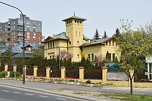
The Krasiński Palace, also known as the Ursynów Palace, and Delight Palace, is a Renaissance Revival palace in Warsaw, Poland, located at 166 Nowoursynowska Street within the district of Ursynów. It was constructed in its current form between 1858 and 1860 for Krasiński family and designed by architect Zygmunt Rospendowski. The original place was built there in 1776 for the Potocki family.

Służew Valley Park
Urban park in Warsaw, Poland
Distance: Approx. 1132 meters
Latitude and longitude: 52.16861111,21.03111111
The Służew Valley Park is an urban park in Warsaw, Poland. It is located in the neighbourhood of Służew, within the district of Mokotów, between Bacha Street, Wilanów Avenue, Puławska Street, and Dolina Służewiecka Street. The park was opened in the 1970s.
Weather in this IP's area
clear sky
8 Celsius
5 Celsius
8 Celsius
10 Celsius
1027 hPa
46 %
1027 hPa
1015 hPa
10000 meters
6.17 m/s
260 degree
06:35:09
16:03:31
