213.133.71.30 - IP Lookup: Free IP Address Lookup, Postal Code Lookup, IP Location Lookup, IP ASN, Public IP
Country:
 Ireland
Region:
City:
Location:
Time Zone:
Postal Code:
ISP:
ASN:
language:
User-Agent:
Proxy IP:
Blacklist:
IP information under different IP Channel
ip-api
Country
Region
City
ASN
Time Zone
ISP
Blacklist
Proxy
Latitude
Longitude
Postal
Route
db-ip
Country
Region
City
ASN
Time Zone
ISP
Blacklist
Proxy
Latitude
Longitude
Postal
Route
IPinfo
Country
Region
City
ASN
Time Zone
ISP
Blacklist
Proxy
Latitude
Longitude
Postal
Route
IP2Location
213.133.71.30Country
ieRegion
tipperary
City
clonmel
Time Zone
Europe/Dublin
ISP
Language
User-Agent
Latitude
Longitude
Postal
ipdata
Country
Region
City
ASN
Time Zone
ISP
Blacklist
Proxy
Latitude
Longitude
Postal
Route
Popular places and events near this IP address
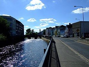
Clonmel
Town in County Tipperary, Ireland
Distance: Approx. 538 meters
Latitude and longitude: 52.3539,-7.7116
Clonmel (Irish: Cluain Meala, meaning 'honey meadow') is the county town and largest settlement of County Tipperary, Ireland. The town is noted in Irish history for its resistance to the Cromwellian army which sacked the towns of Drogheda and Wexford. With the exception of the townland of Suir Island, most of the borough is situated in the civil parish of "St Mary's" which is part of the ancient barony of Iffa and Offa East.
Siege of Clonmel
Distance: Approx. 544 meters
Latitude and longitude: 52.3539,-7.7117
The siege of Clonmel, from 27 April to 18 May 1650, took place during the Cromwellian conquest of Ireland, when Clonmel in County Tipperary was besieged by 8,000 men from the New Model Army under Oliver Cromwell. The garrison of 1,500 commanded by Hugh Dubh O'Neill eventually surrendered after inflicting heavy casualties on the besiegers. O'Neill escaped with some of his troops, but although the Irish Confederate Wars continued until 1653, Clonmel ended effective Royalist resistance in Ireland, and Cromwell returned to England immediately afterwards.

Clonmel Borstal
Former prison system for juvenile offenders in Ireland (1906–1957)
Distance: Approx. 265 meters
Latitude and longitude: 52.355,-7.7
St. Patrick's Borstal Institution, Clonmel, was established in Ireland in 1906 as a place of detention for young male offenders aged between 16 and 21, and located in Clonmel, County Tipperary.
Gaelcholáiste Chéitinn
Gaelcholáiste, secondary school in Clonmel, County Tipperary, Republic of Ireland
Distance: Approx. 553 meters
Latitude and longitude: 52.3538,-7.696
Gaelcholáiste Chéitinn (Irish pronunciation: [ˈɡeːl̪ˠxəˌl̪ˠaːʃtʲə ˈçeːtʲɪn̠ʲ]) is an Irish language-medium second-level school in Clonmel in County Tipperary, Ireland. It is part of the Central Technical Institute (CTI) on the Mall and is one of the three educational entities within CTI. The other two are the secondary school, Coláiste Chluain Meala, and CTI Senior College of Further Education. All three institutions operate under the Tipperary Education and Training Board (ETB).
Clonmel GAA Ground
Distance: Approx. 656 meters
Latitude and longitude: 52.353295,-7.713137
Clonmel GAA Ground, also called Clonmel Sportsground, is a GAA stadium located in the town of Clonmel, County Tipperary, Ireland. It is the home ground of St. Mary's hurling team and Gaelic football team Clonmel Commercials.
St Mary's GAA (Tipperary)
Distance: Approx. 636 meters
Latitude and longitude: 52.354268,-7.713175
St Mary's GAA is a senior Gaelic Athletic Association hurling and camogie club. The club is located in the town of Clonmel, County Tipperary in Ireland.

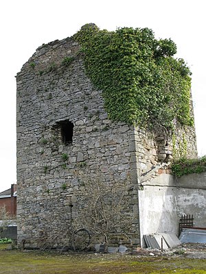
Kickham Barracks
Former military base in Clonmel, Ireland
Distance: Approx. 680 meters
Latitude and longitude: 52.355,-7.6939
Kickham Barracks (Irish: Dún Chiceam) was a military installation in Clonmel, Ireland.

Main Guard (Clonmel)
Courthouse in Clonmel, Ireland
Distance: Approx. 266 meters
Latitude and longitude: 52.353149,-7.701415
The Main Guard is a former courthouse located in Clonmel, Ireland. It is a protected structure and designated as a National Monument.

Clonmel Courthouse
Building in County Tipperary, Ireland
Distance: Approx. 444 meters
Latitude and longitude: 52.35294,-7.6983
Clonmel Courthouse was a judicial facility in Clonmel, County Tipperary, Ireland.
Civic Offices, Clonmel
Municipal building in County Tipperary, Ireland
Distance: Approx. 289 meters
Latitude and longitude: 52.3546,-7.6997
The Civic Offices is a municipal facility on Emmet Road in Clonmel, County Tipperary, Ireland.
Tipperary Museum of Hidden History
Local history museum in County Tipperary, Ireland
Distance: Approx. 354 meters
Latitude and longitude: 52.35547,-7.698749
The Tipperary Museum of Hidden History is a local history museum in Clonmel, County Tipperary, Ireland. It is designated as museum by the National Museum of Ireland and has full accreditation in the Museum Standards Programme for Ireland (MSPI).

Clonmel Town Hall
Municipal building in Clonmel, County Tipperary, Ireland
Distance: Approx. 366 meters
Latitude and longitude: 52.3533,-7.6993
Clonmel Town Hall (Irish: Halla Baile Chluain Meala) is a municipal building in Parnell Street, Clonmel, County Tipperary, Ireland. The building accommodated the offices of Clonmel Borough Council until 2014.
Weather in this IP's area
light rain
7 Celsius
5 Celsius
7 Celsius
7 Celsius
1015 hPa
97 %
1015 hPa
996 hPa
10000 meters
2.28 m/s
7.67 m/s
314 degree
100 %