Country:
Region:
City:
Latitude and Longitude:
Time Zone:
Postal Code:
IP information under different IP Channel
ip-api
Country
Region
City
ASN
Time Zone
ISP
Blacklist
Proxy
Latitude
Longitude
Postal
Route
Luminati
Country
City
sainthelier
ASN
Time Zone
Europe/Jersey
ISP
Newtel Limited
Latitude
Longitude
Postal
IPinfo
Country
Region
City
ASN
Time Zone
ISP
Blacklist
Proxy
Latitude
Longitude
Postal
Route
db-ip
Country
Region
City
ASN
Time Zone
ISP
Blacklist
Proxy
Latitude
Longitude
Postal
Route
ipdata
Country
Region
City
ASN
Time Zone
ISP
Blacklist
Proxy
Latitude
Longitude
Postal
Route
Popular places and events near this IP address

Jersey
British Crown Dependency in the English Channel and country in Europe
Distance: Approx. 493 meters
Latitude and longitude: 49.19,-2.11
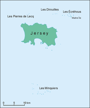
Jersey ( JUR-zee; Jèrriais: Jèrri [ʒɛri]), officially the Bailiwick of Jersey, is an island country in Northwestern Europe and a self-governing British Crown Dependency near the coast of north-west France. It is the largest of the Channel Islands and is 14 miles (23 km) from the Cotentin Peninsula in Normandy. The Bailiwick consists of the main island of Jersey and some surrounding uninhabited islands and rocks including Les Dirouilles, Les Écréhous, Les Minquiers, and Les Pierres de Lecq.

Geography of Jersey
Distance: Approx. 494 meters
Latitude and longitude: 49.19001667,-2.11
Jersey (Jèrriais: Jèrri) is the largest of the Channel Islands, an island archipelago in the St. Malo bight in the western English Channel. It has a total area of 120 square kilometres (46 sq mi) and is part of the British Isles archipelago.

St Helier
Capital town and most populous parish of Jersey
Distance: Approx. 587 meters
Latitude and longitude: 49.18583333,-2.11
St Helier (; Jèrriais: Saint Hélyi; French: Saint-Hélier) is the capital of Jersey, the largest of the Channel Islands in the English Channel. It is the most populous of the twelve parishes of Jersey, with a population of 35,822, over one-third of the island's total population. The town of St Helier is the largest settlement and only town of Jersey.

BBC Radio Jersey
Radio station in Saint Helier
Distance: Approx. 581 meters
Latitude and longitude: 49.1901,-2.1112
BBC Radio Jersey is the BBC's local radio station serving the Bailiwick of Jersey. It broadcasts on FM, AM, DAB+, Freeview and via BBC Sounds from studios on Parade Road in St Helier. According to RAJAR, the station has a weekly audience of 21,000 listeners and a 12.9% share as of December 2023.

States Assembly
Parliament of Jersey, a British Crown Dependency
Distance: Approx. 598 meters
Latitude and longitude: 49.18365,-2.1052
The States Assembly (French: Assemblée des États; Jèrriais: Êtats d'Jèrri) is the parliament of Jersey, formed of the island's 37 deputies and the Connétable of each of the twelve parishes. The origins of the legislature of Jersey lie in the system of self-government according to Norman law guaranteed to the Channel Islands by John, King of England, following the division of Normandy in 1204. The States Assembly has exercised uncontested legislative powers since 1771, when the concurrent law-making power of the Royal Court of Jersey was abolished.

Springfield Stadium
Multi-purpose stadium in St. Helier, Jersey
Distance: Approx. 342 meters
Latitude and longitude: 49.191,-2.1
Springfield Stadium is a multi-purpose stadium in St Helier, Jersey, set in a public park.
Vingtaine du Rouge Bouillon
Vingtaine in Saint Helier
Distance: Approx. 537 meters
Latitude and longitude: 49.1925,-2.10833333
Vingtaine du Rouge Bouillon is one of the six vingtaines of St Helier in Jersey, Channel Islands. The vingtaine is named after the main road through the centre of it, known as Rouge Boullion. The vingtaine also has a number of landmarks, such as the Parade, the Hospital and most of People's Park.

Jersey Railway
Former railway line in Jersey
Distance: Approx. 414 meters
Latitude and longitude: 49.186,-2.107
The Jersey Railway was originally a 3+3⁄4 miles (6.0 km) long standard gauge railway on Jersey in the Channel Islands. Opened in 1870, it was converted to 3 ft 6 in (1,067 mm) narrow-gauge in 1884 and extended 7+3⁄4 miles (12.5 km). The line closed in 1936.
2012 Jersey gas holder fire
2012 fire outbreak at a gas holder in Jersey
Distance: Approx. 430 meters
Latitude and longitude: 49.18777778,-2.09777778
On 4 July 2012, fire broke out at a gas holder, owned by Jersey Gas, on Tunnell Street, in Saint Helier, Jersey. The Jersey Fire and Rescue Service brought the fire under control, and it burnt out during the early hours of 5 July. In the aftermath of the incident Jersey Gas was fined £65,000 by the island's Royal Court and ordered to pay legal costs of £11,000.

St Thomas Church, Jersey
Church in St. Helier, Jersey
Distance: Approx. 158 meters
Latitude and longitude: 49.1888,-2.1056
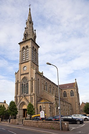
St Thomas Church (Jèrriais: Églyise dé Saint Thonmas) is a historic Roman Catholic church in St. Helier, Jersey. It is the largest church in the Channel Islands, and first opened its doors in 1887.
King Street, Saint Helier
Distance: Approx. 575 meters
Latitude and longitude: 49.1846,-2.1078
King Street (Jèrriais: Rue d'Driéthe), also known as Rue de Derrière, is one of the two parts of the high street of Saint Helier in Jersey. It is a pedestrianised shopping street which runs from Charing Cross at its west end to Queen Street at its east end. It includes a spur that links to Broad Street which is also called King Street in English, but Ruette Haguais in gallicised Jèrriais.

St John Ambulance Jersey
First aid organisation based in Jersey
Distance: Approx. 350 meters
Latitude and longitude: 49.191928,-2.104712
St John Ambulance Jersey, officially the Commandery of the Baliwick of Jersey of the Most Venerable Order of the Hospital of St John of Jerusalem is a charitable voluntary first aid organisation based in Jersey. It teaches first aid and communication skills to over 16s, alongside recruiting volunteers to provide first aid at events, respond to emergencies and work alongside police. On the 3 April 2020, the Jersey Ambulance Service took command of St John Ambulance, to help coordinate its emergency first aid efforts.
Weather in this IP's area
few clouds
13 Celsius
12 Celsius
12 Celsius
13 Celsius
1019 hPa
67 %
1019 hPa
1017 hPa
10000 meters
6.17 m/s
300 degree
20 %
07:22:14
16:24:56

