Country:
 Great Britain
Region:
City:
Latitude and Longitude:
Time Zone:
Postal Code:
IP information under different IP Channel
ip-api
Country
Region
City
ASN
Time Zone
ISP
Blacklist
Proxy
Latitude
Longitude
Postal
Route
IPinfo
Country
Region
City
ASN
Time Zone
ISP
Blacklist
Proxy
Latitude
Longitude
Postal
Route
MaxMind
Country
Region
City
ASN
Time Zone
ISP
Blacklist
Proxy
Latitude
Longitude
Postal
Route
Luminati
Country
GBRegion
eng
City
northolt
ASN
Time Zone
Europe/London
ISP
Six Degrees Technology Group Limited
Latitude
Longitude
Postal
db-ip
Country
Region
City
ASN
Time Zone
ISP
Blacklist
Proxy
Latitude
Longitude
Postal
Route
ipdata
Country
Region
City
ASN
Time Zone
ISP
Blacklist
Proxy
Latitude
Longitude
Postal
Route
Popular places and events near this IP address

Northolt
Area of London
Distance: Approx. 393 meters
Latitude and longitude: 51.54666667,-0.37
Northolt is a town in West London, England, spread across both sides of the A40 trunk road. It is 11 mi (17.7 km) west-northwest of Charing Cross and is one of the seven major towns that make up the London Borough of Ealing. It had a population of 30,304 at the 2011 UK census.

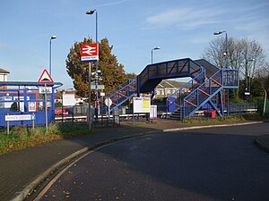
Northolt tube station
London Underground station
Distance: Approx. 228 meters
Latitude and longitude: 51.548,-0.3688
Northolt is a station on the London Underground Central line in Northolt in the London Borough of Ealing. It is in Travelcard Zone 5 and between Greenford and South Ruislip stations.
Northolt Park railway station
National Rail station in London, England
Distance: Approx. 1011 meters
Latitude and longitude: 51.5574,-0.3595
Northolt Park railway station is a National Rail station in Northolt, Greater London. It is in Cadogan Close and spans the boundary between the London Borough of Harrow and the London Borough of Ealing, with a footbridge connecting the north side (leading to Roxeth and South Harrow) to the south side (leading to Northolt and Greenford). South Harrow Tube Station on the Piccadilly line is 0.7 miles (1.1 km) by foot from Northolt Park Station.
London Rangers F.C.
Association football club in England
Distance: Approx. 1413 meters
Latitude and longitude: 51.53898056,-0.35474722
London Rangers FC is a football club based in Wembley in the London Borough of Brent, United Kingdom.

Rogers Family Stadium
Distance: Approx. 1082 meters
Latitude and longitude: 51.5584,-0.3723
Rogers Family Stadium (previously Earlsmead Stadium) is a football stadium in Harrow, north-west London, England. It is the home ground of Harrow Borough F.C. The stadium has a capacity of 3,070 people, which includes 350 seats and standing under cover for 1,000 people. The record attendance is 3000 for an FA Cup match against local rivals Wealdstone FC in 1946.
Northolt High School
Foundation school in Northolt, Middlesex, Greater London, England
Distance: Approx. 775 meters
Latitude and longitude: 51.5524,-0.3765
Northolt High School is a secondary school located in the Northolt area of the London Borough of Ealing, England.
Neasden Foundation F.C.
Football club
Distance: Approx. 1413 meters
Latitude and longitude: 51.53898056,-0.35474722
Neasden Foundation Football Club were a football club based in Neasden, in the London Borough of Brent, England. In 2007, the club was promoted to the Combined Counties League Division One. However, they failed to complete all their matches and were expelled from the Combined Counties League.
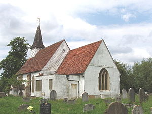
St Mary with St Richard, Northolt
Church
Distance: Approx. 637 meters
Latitude and longitude: 51.54388889,-0.36888889
St Mary the Virgin is a 13th-century Anglican parish church in Northolt, London Borough of Ealing. It is on a slope shared with Belvue Park, the site of a 15th-century manor house — both overlooked the old village of Northolt. It is one of London's smallest churches, its nave measuring 15 yards (14 m) by 8 yards (7.3 m).
RAF South Ruislip
Non-flying Air Force station
Distance: Approx. 1325 meters
Latitude and longitude: 51.55583333,-0.3825
RAF South Ruislip, also known as South Ruislip Air Station, was a non-flying Air Force station located in South Ruislip near London, England. Located close to RAF Northolt, the station was used by the United States Air Force's Third Air Force from 1949 until 1972, when the headquarters were moved to RAF Mildenhall.

Northala Fields
Park in Northolt, Ealing, London
Distance: Approx. 1156 meters
Latitude and longitude: 51.54008889,-0.37379167
Northala Fields is a park located in Northolt, in the London Borough of Ealing. It was opened in 2008 and consists of four artificial hills standing next to the A40 Western Avenue, as well as several fishing lakes, a large field area a children's play area and adjacent café. The hills were constructed using rubble from the demolition of the original Wembley Stadium, which was closed in 2000 and demolished in 2003.

Northolt Manor
Distance: Approx. 585 meters
Latitude and longitude: 51.5444,-0.369
Northolt Manor is a 1.8 hectare scheduled monument, local nature reserve and Site of Borough Importance for Nature Conservation, Grade II, in Northolt in the London Borough of Ealing. It is owned and managed by Ealing Council. Archaeological excavations from 1950 show that the site has been occupied since at least the 7th to early 8th centuries.
Northolt Branch Observatories
Observatory
Distance: Approx. 699 meters
Latitude and longitude: 51.55466,-0.37192
The Northolt Branch Observatories (NBO; Observatory codes: Z80, Z48 and Z37) is an astronomical observatory located in London, England. NBO collects follow-up astrometry of near-Earth asteroids and other small Solar System objects. It focuses on public outreach, sharing images, videos and information about asteroids on social media.
Weather in this IP's area
broken clouds
14 Celsius
13 Celsius
12 Celsius
15 Celsius
1031 hPa
79 %
1031 hPa
1025 hPa
10000 meters
4.63 m/s
50 degree
55 %
06:38:29
19:14:10