212.96.21.251 - IP Lookup: Free IP Address Lookup, Postal Code Lookup, IP Location Lookup, IP ASN, Public IP
Country:
Region:
City:
Location:
Time Zone:
Postal Code:
IP information under different IP Channel
ip-api
Country
Region
City
ASN
Time Zone
ISP
Blacklist
Proxy
Latitude
Longitude
Postal
Route
Luminati
Country
ASN
Time Zone
Africa/Johannesburg
ISP
Vodacom-VB
Latitude
Longitude
Postal
IPinfo
Country
Region
City
ASN
Time Zone
ISP
Blacklist
Proxy
Latitude
Longitude
Postal
Route
IP2Location
212.96.21.251Country
Region
-
City
-
Time Zone
ISP
Language
User-Agent
Latitude
Longitude
Postal
db-ip
Country
Region
City
ASN
Time Zone
ISP
Blacklist
Proxy
Latitude
Longitude
Postal
Route
ipdata
Country
Region
City
ASN
Time Zone
ISP
Blacklist
Proxy
Latitude
Longitude
Postal
Route
Popular places and events near this IP address
Windhoek West
Suburb of Windhoek, Namibia
Distance: Approx. 559 meters
Latitude and longitude: -22.55972222,17.07777778
Windhoek West is a suburb of Windhoek, the capital of Namibia. The Namibia University of Science and Technology (formerly the Polytechnic of Namibia) is located in Windhoek West. Electorally, Windhoek West is located in the Windhoek West Constituency.
National Library of Namibia
National library of Namibia
Distance: Approx. 405 meters
Latitude and longitude: -22.55719444,17.08633333
The National Library of Namibia (NLN) is the legal deposit and copyright library for Namibia. The library is situated in Windhoek. NLN belongs to the National Library and Archives service of the Namibian government, in the Ministry of Education, Arts and Culture.
Independence Avenue (Windhoek)
Distance: Approx. 397 meters
Latitude and longitude: -22.55583333,17.08333333
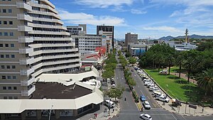
In Windhoek, Namibia, Independence Avenue runs through the heart of downtown and is "easily explored by foot". Prior to independence, the street was known as Kaiserstrasse.

Windhoek railway station
Railway station in Windhoek, Namibia
Distance: Approx. 226 meters
Latitude and longitude: -22.5594,17.081
Windhoek railway station (German: Bahnhof Windhuk) is a railway station serving the city of Windhoek, the capital of Namibia. It is an important station in the Namibian rail network, and it is run by TransNamib.

St. Mary's Cathedral, Windhoek
Distance: Approx. 594 meters
Latitude and longitude: -22.564667,17.082278
St. Mary's Cathedral, known as St. Marien Kathedrale in German, is a Roman Catholic church in Windhoek, Namibia.
Windhoek Public Library
Distance: Approx. 557 meters
Latitude and longitude: -22.5639,17.08556
The Windhoek Public Library is a public library in downtown Windhoek, Namibia. Built in 1925, it is located in Lüderitz Street, sharing a building with the Owela strand of the National Museum of Namibia. From February 2009 to August 2012 the library underwent renovations worth N$ 700,000, which included replacing the carpets with ceramic tiles, adding air conditioning, increasing lighting, and creating a public internet cafe.

Sanlam Centre
Distance: Approx. 92 meters
Latitude and longitude: -22.558904,17.082481
The Sanlam Centre is a building in downtown Windhoek, Namibia. Located on Independence Avenue, the building was built in 1990, the same year as Namibia's independence. It has 15 floors and 28,000 m2 of floor space.

Windhoek Central Business District
Distance: Approx. 92 meters
Latitude and longitude: -22.55888889,17.0825
Windhoek Central Business District (short: Windhoek Central) is the inner city area of Windhoek, capital of Namibia. It is surrounded by the suburbs of Windhoek West and Hochland Park in the west, Windhoek-North in the north, Eros, Klein-Windhoek, Luxushügel and Auasblick in the east, and Suiderhof and Southern Industrial in the south. Windhoek Central consists of residential and business properties as well as public spaces.

National Art Gallery of Namibia
Art museum in Windhoek, Namibia
Distance: Approx. 350 meters
Latitude and longitude: -22.56166667,17.08555556
The National Art Gallery of Namibia (NAGN) is a state-owned art gallery situated in Windhoek, the capital city of Namibia. It was founded in 1990. The goal of this institution is to preserve and encourage art in Namibia.
Roman Catholic Hospital
Hospital in Windhoek, Namibia
Distance: Approx. 538 meters
Latitude and longitude: -22.5641,17.082
The Roman Catholic Hospital is a private hospital in Windhoek, Namibia run by the Roman Catholic Church. Founded in 1907 by the Benedictine Missionary Sisters of Tutzing, the Roman Catholic Hospital had 87 beds in 2007.
National Archives of Namibia
Distance: Approx. 405 meters
Latitude and longitude: -22.55719444,17.08633333
The National Archives of Namibia (NAN) is the national archives of Namibia, located in Windhoek. It was established in 1939 and today shares a building with the National Library of Namibia. NAN belongs to the National Library and Archives service of the Namibian government, in the Ministry of Education, Arts and Culture.
Turnhalle (Windhoek)
Distance: Approx. 274 meters
Latitude and longitude: -22.5606,17.08553
The Turnhalle (English: sports hall) is a building in Windhoek, the capital of Namibia. Built during the era of Imperial Germany's colonisation of South West Africa, it has been through a variety of uses, most prominently as the venue for the 1975–1977 Turnhalle Constitutional Conference, an attempt to quell armed resistance waged by the People's Liberation Army of Namibia against South African occupation. The Turnhalle housed the Tribunal court of the Southern African Development Community (SADC) until disbandment in 2012.
Weather in this IP's area
clear sky
23 Celsius
22 Celsius
23 Celsius
24 Celsius
1012 hPa
42 %
1012 hPa
838 hPa
10000 meters
2.06 m/s
180 degree
8 %

