212.93.55.67 - IP Lookup: Free IP Address Lookup, Postal Code Lookup, IP Location Lookup, IP ASN, Public IP
Country:
Region:
City:
Location:
Time Zone:
Postal Code:
IP information under different IP Channel
ip-api
Country
Region
City
ASN
Time Zone
ISP
Blacklist
Proxy
Latitude
Longitude
Postal
Route
Luminati
Country
ASN
Time Zone
Europe/Copenhagen
ISP
Den Danske Bank A/S
Latitude
Longitude
Postal
IPinfo
Country
Region
City
ASN
Time Zone
ISP
Blacklist
Proxy
Latitude
Longitude
Postal
Route
IP2Location
212.93.55.67Country
Region
midtjylland
City
brabrand
Time Zone
Europe/Copenhagen
ISP
Language
User-Agent
Latitude
Longitude
Postal
db-ip
Country
Region
City
ASN
Time Zone
ISP
Blacklist
Proxy
Latitude
Longitude
Postal
Route
ipdata
Country
Region
City
ASN
Time Zone
ISP
Blacklist
Proxy
Latitude
Longitude
Postal
Route
Popular places and events near this IP address
Brabrand
Postal district in Central Denmark Region, Kingdom of Denmark
Distance: Approx. 763 meters
Latitude and longitude: 56.15,10.11666667
Brabrand (Danish pronunciation: [ˈpʁɑːˌpʁɑnˀ]) is a postal district of Aarhus Municipality, Denmark. South of Brabrand, in the Aarhus river-valley, is the largest recreational area of Aarhus Municipality, comprising the Brabrand Lake and the meadow-lake of Årslev, with surrounding natural sites.
Danmarks Grimmeste Festival
Music festival in Aarhus
Distance: Approx. 2062 meters
Latitude and longitude: 56.1683,10.1247
Danmarks Grimmeste Festival (Denmark's ugliest Festival) is a small music festival, held each summer at a farm in Skjoldhøjkilen, Brabrand; a suburb of Aarhus, Denmark. Danmarks Grimmeste Festival features a broad range of genres, including rock, pop, electronic, hip hop and punk music. It is based on volunteers and about 5,000 people attended the 2015 festival.
Stavtrup
Neighborhood in Aarhus Municipality, Central Denmark Region, Kingdom of Denmark
Distance: Approx. 2578 meters
Latitude and longitude: 56.130674,10.116059
Stavtrup is a western suburb of Aarhus in Denmark. It is located 7 km from the city centre and has a population of 3,729 (1 January 2010). Since 1 January 2011, Stavtrup is officially a part of Aarhus' urban area under the postal district of Viby J. Stavtrup is largely a residential area and there is easy access to the nature around Brabrand Lake.
Admiral Danish Fleet
Military unit
Distance: Approx. 691 meters
Latitude and longitude: 56.15416667,10.09472222
The Admiral Danish Fleet (ADMDANFLT) (Danish: Søværnets Operative Kommando lit. 'The Navy's Operational Command') was the operationally supreme organisation of the Royal Danish Navy between 1 January 1991 and 30 September 2014.

Skjoldhøjkilen
Danish recreational and natural site
Distance: Approx. 2172 meters
Latitude and longitude: 56.169,10.126
Skjoldhøjkilen is a recreational and natural site, in the district of Brabrand in the western part of Aarhus in Denmark. It stretches westwards from Hasle Hills, like a wavy green strip of meadows, small lakes and woodlands. It is 3.5 km long and just as Hasle Hills, it is administered by the self-governing institution 'Hasle Bakker'.

Brabrand Lake
Lake in Braband, Denmark
Distance: Approx. 1265 meters
Latitude and longitude: 56.145,10.12
Brabrand Lake (Danish: Brabrand-søen or Brabrand Sø) is a lake in the district of Brabrand (Gellerup), west of Aarhus city, Denmark. The Aarhus River passes through Brabrand Lake and it is possible to canoe all the way to the inner city from here. The lake is oblong-shaped.

Elev
Town in Central Denmark Region, Kingdom of Denmark
Distance: Approx. 1281 meters
Latitude and longitude: 56.143,10.1156
Elev is a small town in Aarhus Municipality, Central Denmark Region in Denmark with a population of 1,934 (1 January 2024). Elev is situated 12 kilometers northwest of Aarhus on the northern slopes of Egådalen valley, between Lystrup and Trige, close to the motorway Djurslandsmotorvejen, which connects with E45. Elev is part of Elev Parish where Elev Church is situated.

Hårup
Town in Central Denmark Region, Kingdom of Denmark
Distance: Approx. 2410 meters
Latitude and longitude: 56.17,10.13
Hårup is a town in Aarhus Municipality, Central Denmark Region in Denmark with a population of 900 (1 January 2024). Hårup is situated north of the city of Aarhus between the towns Todbjerg and Mejlby in Todbjerg Parish close to Trige og Ølsted.
Brabrand Church
Church in Denmark, Denmark
Distance: Approx. 301 meters
Latitude and longitude: 56.151794,10.101451
Brabrand Church (Danish: Brabrand Kirke) is a church located in Brabrand Parish in Aarhus, Denmark. The church is situated in the neighbourhood Brabrand by Brabrand Lake, west of Midtbyen. The church was originally devoted to St.

Højen 13
Listed villa in Aarhus, Denmark
Distance: Approx. 573 meters
Latitude and longitude: 56.1572,10.1113
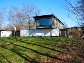
Højen 13 is a villa and listed building in Aarhus, Denmark. The villa was built in 1958 and was listed in the Danish registry of protected buildings and places by the Danish Heritage Agency on 11 January 2008. The house was built by the architect Knud Friis as his home and study on a hill overlooking Brabrand Lake in the Brabrand suburb.

Jarlsminde
Building in Aarhus, Denmark
Distance: Approx. 2637 meters
Latitude and longitude: 56.1328,10.1276
Jarlsminde is a farm and a listed building in Aarhus, Denmark. The farm was built in 1798 and was listed in the Danish national registry of protected buildings and places by the Danish Heritage Agency on 3 June 1997. The farm is situated in the suburb Stavtrup about 7-8 km.
Sønder Aarslev Church
Church in Aarhus, Denmark
Distance: Approx. 2191 meters
Latitude and longitude: 56.1522,10.0704
Sønder Aarslev Church (Danish: Sønder Aarslev Kirke) is a church located in Årslev, a small village-suburb in the western parts of Aarhus, Denmark. Årslev is situated in the Brabrand district, west of Aarhus city center. It is the church of Sønder Årslev Parish within the Church of Denmark and serves a parish population of 993 (2016).
Weather in this IP's area
clear sky
-1 Celsius
-6 Celsius
-1 Celsius
-1 Celsius
1032 hPa
90 %
1032 hPa
1025 hPa
10000 meters
3.5 m/s
9.17 m/s
334 degree
9 %


