Country:
 Netherlands
Region:
City:
Latitude and Longitude:
Time Zone:
Postal Code:
IP information under different IP Channel
ip-api
Country
Region
City
ASN
Time Zone
ISP
Blacklist
Proxy
Latitude
Longitude
Postal
Route
IPinfo
Country
Region
City
ASN
Time Zone
ISP
Blacklist
Proxy
Latitude
Longitude
Postal
Route
MaxMind
Country
Region
City
ASN
Time Zone
ISP
Blacklist
Proxy
Latitude
Longitude
Postal
Route
Luminati
Country
NLRegion
ze
City
middelburg
ASN
Time Zone
Europe/Amsterdam
ISP
DELTA Fiber Nederland B.V.
Latitude
Longitude
Postal
db-ip
Country
Region
City
ASN
Time Zone
ISP
Blacklist
Proxy
Latitude
Longitude
Postal
Route
ipdata
Country
Region
City
ASN
Time Zone
ISP
Blacklist
Proxy
Latitude
Longitude
Postal
Route
Popular places and events near this IP address

Middelburg, Zeeland
City in Zeeland, Netherlands
Distance: Approx. 1624 meters
Latitude and longitude: 51.5,3.61666667
Middelburg (Dutch: [ˈmɪdəlbʏr(ə)x] ) is a city and municipality in the south-western Netherlands serving as the capital of the province of Zeeland. Situated on the central peninsula of the Zeeland province, Midden-Zeeland (consisting of former islands Walcheren, Noord-Beveland and Zuid-Beveland), it has a population of about 48,000. In terms of technology, Middelburg played a role in the Scientific Revolution at the early modern period.
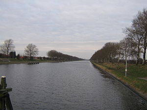
Canal through Walcheren
Canal in Netherlands
Distance: Approx. 1540 meters
Latitude and longitude: 51.49638889,3.61916667
The Canal through Walcheren in the Netherlands crosses the east of Walcheren. It connects the Westerschelde and the Veerse Meer.
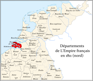
Bouches-de-l'Escaut
Distance: Approx. 770 meters
Latitude and longitude: 51.4833,3.6
Bouches-de-l'Escaut (French: [buʃ.də.lɛ.sko], "Mouths of the Scheldt"; Dutch: Monden van de Schelde) was a department of the First French Empire in the present-day Netherlands. It was formed in 1810, when the Kingdom of Holland was annexed by France. Its territory corresponded with the present-day Dutch province of Zeeland, minus Zeelandic Flanders, which was part of the department of Escaut.

Zeeland Library
Official library of Zeeland, Netherlands
Distance: Approx. 1330 meters
Latitude and longitude: 51.4963,3.6158
ZB Bibliotheek van Zeeland, the Zeeland Library (Zeeuwse Bibliotheek) in Middelburg, Netherlands, is the largest cultural institution of the province of Zeeland and fulfills the task of public library for Middelburg, scientific library for Zeeland (it is a WSF-library) and the academic library of University College Roosevelt. It also has the function of Provincial Library Central for libraries, schools and institutions in the province.

Middelburg railway station
Railway station in the Netherlands
Distance: Approx. 1405 meters
Latitude and longitude: 51.495,3.61805556
Middelburg is a railway station in southern Middelburg, Netherlands. The station opened on 1 March 1872 and is located on the Roosendaal–Vlissingen railway. The services are operated by Nederlandse Spoorwegen.

Vlissingen Souburg railway station
Railway station in the Netherlands
Distance: Approx. 2850 meters
Latitude and longitude: 51.46472222,3.59527778
Vlissingen Souburg (English: Flushing Souburg) is a railway station located in Oost-Souburg, Netherlands. The station was opened on 31 May 1986 and is located on the Roosendaal–Vlissingen railway. It is the westernmost station in the Netherlands.

Het Groot Paradijs
Restaurant in Middelburg, Netherlands
Distance: Approx. 1646 meters
Latitude and longitude: 51.50027222,3.61668056
Het Groot Paradijs is a defunct restaurant in Middelburg, in the Netherlands. It was a fine dining restaurant that was awarded one Michelin star in 1996 and retained that rating until 2002. For 2007, it was again awarded a Michelin star.

Siege of Middelburg (1572–1574)
1572 siege
Distance: Approx. 1624 meters
Latitude and longitude: 51.5,3.61666667
The siege of Middelburg (1572–1574) lasted over a year during the Eighty Years' War. A Dutch rebel army with the support of the English laid siege to Middelburg, which was being held by Spanish forces under Cristóbal de Mondragón, on 4 November 1572. The Spanish held out and only capitulated on 18 February 1574, when news arrived that a relief effort to save Middelburg was defeated at Rimmerswiel.
University College Roosevelt
Liberal arts and science college in Middelburg, Netherlands
Distance: Approx. 1279 meters
Latitude and longitude: 51.49916667,3.61083333
University College Roosevelt (UCR), formerly known as Roosevelt Academy (RA), is a small, honors undergraduate liberal arts and science college located in Middelburg in the Netherlands and the sole university in Zeeland. It offers a residential setting, and is an international honors college of Utrecht University. It is named in honour of the Roosevelt family, which traces its ancestry to the province of Zeeland.

Middelburg Town Hall
15th-century building in the Netherlands
Distance: Approx. 1254 meters
Latitude and longitude: 51.4989,3.6108
Middelburg Town Hall is situated at the market of Middelburg, Zeeland. It is considered one of the finest Gothic buildings in the Netherlands. Construction began in 1452 and was supervised by several generations of the Flemish family of architects Keldermans.

Middelburg Abbey
Building in Middelburg, Netherlands
Distance: Approx. 1590 meters
Latitude and longitude: 51.50027778,3.61555556
Middelburg Abbey (The Abbey of Our Lady) is a former Premonstratensian abbey in Middelburg, the Netherlands. At one time it was the centre of a large monastic complex. Today parts of what survives are used for a museum and as offices.
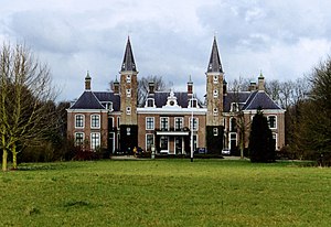
Ter Hooge Castle
Castle in the Netherlands
Distance: Approx. 767 meters
Latitude and longitude: 51.490694,3.588264
Ter Hooge Castle is an 18th-century manor in Middelburg. It includes parts of a medieval castle.
Weather in this IP's area
overcast clouds
16 Celsius
16 Celsius
16 Celsius
18 Celsius
1014 hPa
87 %
1014 hPa
1014 hPa
10000 meters
3.09 m/s
290 degree
100 %
08:14:58
18:46:05