Country:
 Germany
Region:
City:
Latitude and Longitude:
Time Zone:
Postal Code:
IP information under different IP Channel
ip-api
Country
Region
City
ASN
Time Zone
ISP
Blacklist
Proxy
Latitude
Longitude
Postal
Route
IPinfo
Country
Region
City
ASN
Time Zone
ISP
Blacklist
Proxy
Latitude
Longitude
Postal
Route
MaxMind
Country
Region
City
ASN
Time Zone
ISP
Blacklist
Proxy
Latitude
Longitude
Postal
Route
Luminati
Country
DERegion
be
City
berlin
ASN
Time Zone
Europe/Berlin
ISP
DNS:NET Internet Service GmbH
Latitude
Longitude
Postal
db-ip
Country
Region
City
ASN
Time Zone
ISP
Blacklist
Proxy
Latitude
Longitude
Postal
Route
ipdata
Country
Region
City
ASN
Time Zone
ISP
Blacklist
Proxy
Latitude
Longitude
Postal
Route
Popular places and events near this IP address

Pankow
Borough of Berlin in Germany
Distance: Approx. 575 meters
Latitude and longitude: 52.56666667,13.4
Pankow (German: [ˈpaŋkoː] ) is the second largest area of Berlin by population (424,000 in 2023). In Berlin's 2001 administrative reform, it was merged with the former boroughs of Prenzlauer Berg and Weißensee; the resulting borough retained the name Pankow. Pankow was sometimes claimed by the Western Allies (United States, United Kingdom, and France) to be the capital of the German Democratic Republic (East Germany), while the German Democratic Republic itself considered East Berlin to be its capital.

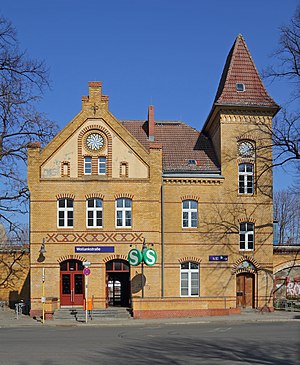
Berlin-Pankow station
Railway station in Pankow, Germany
Distance: Approx. 365 meters
Latitude and longitude: 52.56666667,13.41111111
Berlin-Pankow is a station on the Berlin–Szczecin railway, situated in Berlin's Pankow district. It is served by the S-Bahn lines S2, S8 and S26 and is the northern terminus of the U-Bahn line U2.

Vinetastraße (Berlin U-Bahn)
Station of the Berlin U-Bahn
Distance: Approx. 1145 meters
Latitude and longitude: 52.55944444,13.41333333
Vinetastraße is a Berlin U-Bahn station in the Pankow district, located on the U2. It was opened in 1930, and for decades was the northern terminus of the U2, until the line was extended to the Pankow S-Bahn station in 2000.

Schönhausen Palace
Palace in Berlin, Germany
Distance: Approx. 1036 meters
Latitude and longitude: 52.57833333,13.40555556
Schönhausen Palace (German: Schloss Schönhausen) is a Baroque palace at Niederschönhausen, in the borough of Pankow, Berlin, Germany. It is surrounded by gardens through which the Panke river runs. The palace is maintained by the Prussian Palaces and Gardens Foundation Berlin-Brandenburg and reopened to the public in 2009 after extensive restoration.
Berlin Wollankstraße station
Railway station in Pankow, Germany
Distance: Approx. 1118 meters
Latitude and longitude: 52.56527778,13.39222222
Berlin Wollankstraße (German: Bahnhof Wollankstraße) is a railway station in the Pankow district of Berlin, Germany. It is served by the Berlin S-Bahn and several local buses.
Majakowskiring
Distance: Approx. 758 meters
Latitude and longitude: 52.57527778,13.40277778
The Majakowskiring (named after Vladimir Mayakovsky) is an ellipse-shaped street in the Pankow district of Berlin, Germany, in the Niederschönhausen locality. It was famous as the residence of many senior figures in the government of the German Democratic Republic. The Majakowskiring neighbourhood (Ortslage) is situated between Grabbeallee to the west and northwest, Ossietzkystraße and Schlosspark to the east, Schloss Schönhausen to the northeast, and the Panke river to the south.
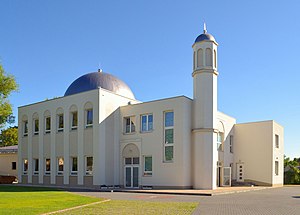
Khadija Mosque
Mosque in Berlin, Germany
Distance: Approx. 1631 meters
Latitude and longitude: 52.57277778,13.43083333
Khadija Mosque (German: Khadija-Moschee) is a mosque located in Heinersdorf, Pankow, Berlin, Germany. It is property of the Ahmadiyya Muslim Community, and the first mosque in former East Germany, opening on 16 October 2008. The mosque has a 12-metre-high (39 ft) minaret and has capacity for 500 worshippers.
Pankow (locality)
Quarter of Berlin in Germany
Distance: Approx. 282 meters
Latitude and longitude: 52.56916667,13.40333333
Pankow (German: [ˈpaŋkoː] ) is a locality (Ortsteil) of Berlin in the district (Bezirk) of Pankow. Until 2001 it was an autonomous district with the localities of Karow, Niederschönhausen, Wilhelmsruh, Rosenthal, Blankenfelde, Buch and Französisch Buchholz.
Niederschönhausen
Quarter of Berlin, Germany
Distance: Approx. 1664 meters
Latitude and longitude: 52.58333333,13.4
Niederschönhausen (German pronunciation: [ˈniːdɐˈʃøːnˌhaʊ̯zn̩] , literally "Lower Schönhausen") is a locality (Ortsteil) within the borough (Bezirk) of Pankow in Berlin, Germany. It is also known as "Pankow-Schönhausen" to differ it from Hohenschönhausen in Berlin-Lichtenberg. From 1949 until 1960 Schönhausen Palace and the adjacent Majakowskiring quarter were the residence of several members of the East German government, commonly referred to as Pankow by the West German media.

Bornholmer Straße border crossing
Former border checkpoint in Berlin
Distance: Approx. 1710 meters
Latitude and longitude: 52.55472222,13.39861111
The Bornholmer Straße border crossing was one of the border crossings between East Berlin and West Berlin between 1961 and 1990. The crossing was named after the street on which it is located, Bornholmer Straße ("Bornholm Street"), which in turn was named after the Danish Baltic Sea island of Bornholm. The actual border between East and West Berlin ran along railway lines which were crossed by the Bösebrücke.
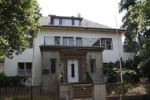
Jewish Orphanage Berlin-Pankow
Distance: Approx. 324 meters
Latitude and longitude: 52.56861111,13.41222222
Jewish Orphanage Berlin-Pankow (German: Jüdisches Waisenhaus) is a former Jewish orphanage and a listed building in Berlin-Pankow. It was built in 1882 to house refugee children. It was later destroyed by fire and a new building was erected on the same site in 1913.

List of ambassadors of Eritrea to Germany
Distance: Approx. 1404 meters
Latitude and longitude: 52.556634,13.410615
The Eritrean ambassador in Berlin is the official representative of the Government in Asmara to the Government of the Germany.
Weather in this IP's area
overcast clouds
16 Celsius
16 Celsius
15 Celsius
17 Celsius
1017 hPa
69 %
1017 hPa
1012 hPa
10000 meters
5.36 m/s
6.26 m/s
147 degree
94 %
07:37:34
18:05:02