Country:
 Germany
Region:
City:
Latitude and Longitude:
Time Zone:
Postal Code:
IP information under different IP Channel
ip-api
Country
Region
City
ASN
Time Zone
ISP
Blacklist
Proxy
Latitude
Longitude
Postal
Route
IPinfo
Country
Region
City
ASN
Time Zone
ISP
Blacklist
Proxy
Latitude
Longitude
Postal
Route
MaxMind
Country
Region
City
ASN
Time Zone
ISP
Blacklist
Proxy
Latitude
Longitude
Postal
Route
Luminati
Country
DEASN
Time Zone
Europe/Berlin
ISP
DNS:NET Internet Service GmbH
Latitude
Longitude
Postal
db-ip
Country
Region
City
ASN
Time Zone
ISP
Blacklist
Proxy
Latitude
Longitude
Postal
Route
ipdata
Country
Region
City
ASN
Time Zone
ISP
Blacklist
Proxy
Latitude
Longitude
Postal
Route
Popular places and events near this IP address

Prenzlauer Berg
Ortsteil of Berlin in Germany
Distance: Approx. 1543 meters
Latitude and longitude: 52.53916667,13.42416667
Prenzlauer Berg (German pronunciation: [ˌpʁɛnt͡slaʊ̯ɐ ˈbɛʁk] ) is a locality of Berlin, forming the southerly and most urban district of the borough of Pankow. From its founding in 1920 until 2001, Prenzlauer Berg was a district of Berlin in its own right. However, that year it was incorporated (along with the borough of Weißensee) into the greater district of Pankow.

Weißensee cemetery
Jewish cemetery in Weißensee, Berlin, Germany
Distance: Approx. 989 meters
Latitude and longitude: 52.54472222,13.45833333
The Weißensee Cemetery is a Jewish cemetery located in the neighborhood of Weißensee in Berlin, Germany. It is the second largest Jewish cemetery in Europe. The cemetery covers approximately 42 ha (100 acres) and contains approximately 115,000 graves.
Weißensee (Berlin)
Quarter of Berlin in Germany
Distance: Approx. 1601 meters
Latitude and longitude: 52.55,13.46666667
Weißensee (German pronunciation: [ˌvaɪ̯sn̩ˈzeː]) is a quarter in the borough of Pankow in Berlin, Germany, that takes its name from the small lake Weißer See (literally 'White Lake') within it. Before Berlin's 2001 administrative reform, Weißensee was a borough in its own right, consisting of the quarters of Weißensee, Heinersdorf, Blankenburg, Karow, and Stadtrandsiedlung Malchow. A fictional German-language TV series by the same name is set in the borough between 1980 and 1990 during the communist era.
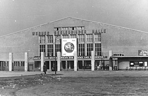
Werner-Seelenbinder-Halle
Distance: Approx. 1710 meters
Latitude and longitude: 52.53111111,13.44944444
Werner-Seelenbinder-Halle was an indoor sporting arena located in the Prenzlauer Berg district of Berlin, Germany. It was named after the executed Berlin resistance fighter Werner Seelenbinder, a German wrestling champion at several European championships and 1936 Summer Olympics athlete. The arena opened in 1950 in what was then East Berlin, in a converted hall that had been part of the central cattle market and slaughterhouse complex.

Velodrom (Berlin)
Sports arena and velodrome in Berlin, Germany
Distance: Approx. 1763 meters
Latitude and longitude: 52.53083333,13.45083333
The Velodrom (velodrome) is an indoor track cycling arena, in the Prenzlauer Berg locality of Berlin, Germany. Holding up to 12,000 people, it was also Berlin's largest concert venue, until the opening of O2 World in 2008. It is part of a larger complex, which includes a swimming pool as well, built in the course of the unsuccessful Berlin application for the 2000 Summer Olympics.

Ernst-Thälmann-Park
Distance: Approx. 1123 meters
Latitude and longitude: 52.53805556,13.43388889
Ernst-Thälmann-Park is a park in the centre of the Prenzlauer Berg district in Berlin. It was laid out in 1986 at the site of a former coal gas plant and named after the former Communist party leader Ernst Thälmann (1886–1944). The former plant built in 1874 was closed in 1981, the last gasometer was demolished in 1984.

Berlin Greifswalder Straße station
Railway station in Berlin, Germany
Distance: Approx. 771 meters
Latitude and longitude: 52.53972222,13.43944444
S-Bhf. Greifswalder Straße is a railway station in the Prenzlauer Berg district of Berlin. It is served by the S-Bahn lines S41, S42, S8 and S85.

Berlin Prenzlauer Allee station
Railway station in Berlin, Germany
Distance: Approx. 1229 meters
Latitude and longitude: 52.54388889,13.42611111
Prenzlauer Allee is a railway station in the Prenzlauer Berg neighbourhood of Berlin, named after the Prenzlauer Allee road. Situated on the Berlin Ringbahn, it is served by the S-Bahn lines S41, S42, S8 and S85. The station is barrier-free.

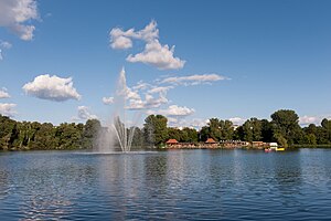
Weißer See (Berlin)
Distance: Approx. 1632 meters
Latitude and longitude: 52.55416667,13.46402778
Weißer See (German pronunciation: [ˈvaɪ̯sɐ ˈzeː], literally "White Lake") is a lake in the Weissensee district of Berlin, Germany. Its surface area is 8.3011ha (84,000m2) and volume 360,606m3. With a depth of 10.64m (average depth 4.34m) it is one of the deepest areas of water in Berlin.

Gethsemane Church
Distance: Approx. 1850 meters
Latitude and longitude: 52.5475,13.41666667
Gethsemane Church (German: Gethsemanekirche) is one of four church buildings of the Lutheran Northern Prenzlauer Berg Evangelical Congregation (German: Evangelische Kirchengemeinde Prenzlauer Berg-Nord), within the Evangelical Church of Berlin-Brandenburg-Silesian Upper Lusatia, an umbrella organisation which includes Lutheran, Reformed, and United Protestant Calvinist congregations. Gethsemane Church is the best known church in the locality of Prenzlauer Berg, in Berlin's borough of Pankow. The church was named after the Garden of Gethsemane (Old Aramaic גת שמנא, transliterated Gath Šmānê, Hebrew: גת שמנים, translit.

Prenzlauer Allee
Distance: Approx. 1149 meters
Latitude and longitude: 52.54416667,13.42722222
Prenzlauer Allee is a major avenue in the Prenzlauer Berg district of the German capital Berlin and one of the main thoroughfares of the north-eastern Pankow borough. The arterial road connects the centre of former East Berlin at Alexanderplatz via Karl-Liebknecht-Straße with the far north-eastern districts and the orbital motorway Berliner Ring (BAB 10) via the Bundesautobahn 114. It starts at Prenzlauer Tor, formerly the site of a historic city gate on the road to Prenzlau, leading uphill northwards to the border with the Pankow district, where it continues as Prenzlauer Promenade.

Zeiss Major Planetarium
Planetarium in Prenzlauer Berg, Berlin, Germany
Distance: Approx. 1132 meters
Latitude and longitude: 52.54298611,13.42798611
The Zeiss Major Planetarium (German Zeiss-Großplanetarium) is a planetarium in Berlin, and one of the largest modern stellar theatres in Europe. It is located on the borders of the Ernst-Thälmann-Park housing estates in the Prenzlauer Berg locality of Berlin.
Weather in this IP's area
clear sky
20 Celsius
20 Celsius
19 Celsius
22 Celsius
1011 hPa
73 %
1011 hPa
1005 hPa
10000 meters
3.09 m/s
90 degree
06:29:21
19:38:40