212.89.131.53 - IP Lookup: Free IP Address Lookup, Postal Code Lookup, IP Location Lookup, IP ASN, Public IP
Country:
 Germany
Region:
City:
Location:
Time Zone:
Postal Code:
ISP:
ASN:
language:
User-Agent:
Proxy IP:
Blacklist:
IP information under different IP Channel
ip-api
Country
Region
City
ASN
Time Zone
ISP
Blacklist
Proxy
Latitude
Longitude
Postal
Route
db-ip
Country
Region
City
ASN
Time Zone
ISP
Blacklist
Proxy
Latitude
Longitude
Postal
Route
IPinfo
Country
Region
City
ASN
Time Zone
ISP
Blacklist
Proxy
Latitude
Longitude
Postal
Route
IP2Location
212.89.131.53Country
deRegion
saarland
City
ottweiler
Time Zone
Europe/Berlin
ISP
Language
User-Agent
Latitude
Longitude
Postal
ipdata
Country
Region
City
ASN
Time Zone
ISP
Blacklist
Proxy
Latitude
Longitude
Postal
Route
Popular places and events near this IP address

Hirzweiler
Distance: Approx. 5860 meters
Latitude and longitude: 49.4,7.08333333
Hirzweiler is a small village in Germany, in the Bundesland Saarland. The settlement was first mentioned in a document dated 1365. There are currently roughly 1,200 people living in Hirzweiler.

Sankt Wendel
Town in Saarland, Germany
Distance: Approx. 7279 meters
Latitude and longitude: 49.46666667,7.16666667
Sankt Wendel [zaŋkt ˈvɛndl̩] is a town in northeastern Saarland. It is situated on the river Blies 36 km northeast of Saarbrücken, the capital of Saarland, and is named after Saint Wendelin of Trier. According to a survey by the German Association for Housing, Town Planning and Land Use Regulation, St.

Neunkirchen, Saarland
Town in Saarland, Germany
Distance: Approx. 5713 meters
Latitude and longitude: 49.35,7.16666667
Neunkirchen (German: [ˈnɔʏnˌkɪʁçn̩] ; Palatine German: Neinkeije) is a town and a municipality in Saarland, Germany. It is the largest town in, and the seat of the district of Neunkirchen. It is situated on the river Blies, approx.
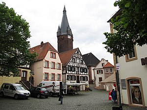
Ottweiler
Town in Saarland, Germany
Distance: Approx. 3860 meters
Latitude and longitude: 49.36666667,7.16666667
Ottweiler () is a municipality, former seat of the district of Neunkirchen, in Saarland, Germany. It is situated on the river Blies, approx. 7 km north of Neunkirchen, and 25 km northeast of Saarbrücken.
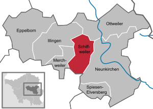
Schiffweiler
Municipality in Saarland, Germany
Distance: Approx. 5170 meters
Latitude and longitude: 49.36666667,7.11666667
Schiffweiler is a municipality in the district of Neunkirchen, in Saarland, Germany. It is situated approximately 5 km northwest of Neunkirchen, and 20 km northeast of Saarbrücken.
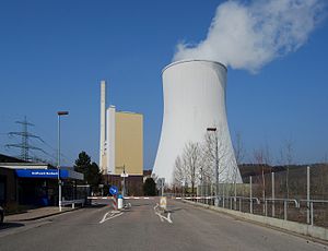
Bexbach Power Station
Distance: Approx. 6823 meters
Latitude and longitude: 49.36305556,7.23777778
Bexbach Power Station is a coal-fired power station in the Bexbach municipality of Saarland, Germany. It has an output capacity of 773 megawatts. The chimney of the power station is 240 metres high.
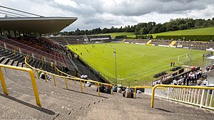
Ellenfeldstadion
Distance: Approx. 7282 meters
Latitude and longitude: 49.33666667,7.17972222
The Ellenfeldstadion is a grass surface, multi-purpose stadium in Neunkirchen, Saarland, Germany. It was built in 1911 and 1912, completely reconstructed between 1962 and 1964 and partially renovated in 2002. It is currently used mostly for football matches and is the home of Borussia Neunkirchen.

Zentrum für Biodokumentation
Distance: Approx. 6875 meters
Latitude and longitude: 49.35,7.11138889
Zentrum für Biodokumentation is a museum in Saarland, Germany.
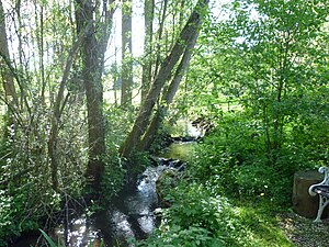
Oster (Blies)
River in Germany
Distance: Approx. 3697 meters
Latitude and longitude: 49.37194444,7.18805556
The Oster is a river of Saarland, Germany. It flows into the Blies near Neunkirchen.

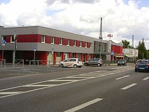
Neunkirchen Hauptbahnhof
Railway station in Neunkirchen, Germany
Distance: Approx. 5446 meters
Latitude and longitude: 49.35305556,7.17666667
Neunkirchen Hauptbahnhof is a railway station in the district town of Neunkirchen in the German state of Saarland. Here the Nahe Valley Railway (Nahetalbahn) intersects with the Homburg–Neunkirchen railway and the Fischbach Valley Railway (Fischbachtalbahn). It is classified by Deutsche Bahn as a category 3 station.
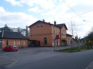
Ottweiler (Saar) station
Railway station in Ottweiler, Germany
Distance: Approx. 182 meters
Latitude and longitude: 49.402388,7.166077
Ottweiler (Saar) station is centrally located in the town of Ottweiler in the German state of the Saarland on the Nahe Valley Railway, which was opened in 1860. Since 1937, the Ottweiler–Schwarzerden line (also called the Ostertalbahn, Oster Valley Railway) has branched off in Ottweiler; it is now used as a museum railway. The station is classified by Deutsche Bahn as a category 5 station.
St. Wendel station
Railway station in Sankt Wendel, Germany
Distance: Approx. 7311 meters
Latitude and longitude: 49.466966,7.165644
St. Wendel station is the most important station in the town of St. Wendel in the German state of Saarland.
Weather in this IP's area
clear sky
2 Celsius
-1 Celsius
0 Celsius
3 Celsius
1031 hPa
81 %
1031 hPa
990 hPa
10000 meters
2.24 m/s
5.36 m/s
61 degree
5 %