Country:
 Germany
Region:
City:
Latitude and Longitude:
Time Zone:
Postal Code:
IP information under different IP Channel
ip-api
Country
Region
City
ASN
Time Zone
ISP
Blacklist
Proxy
Latitude
Longitude
Postal
Route
IPinfo
Country
Region
City
ASN
Time Zone
ISP
Blacklist
Proxy
Latitude
Longitude
Postal
Route
MaxMind
Country
Region
City
ASN
Time Zone
ISP
Blacklist
Proxy
Latitude
Longitude
Postal
Route
Luminati
Country
DEASN
Time Zone
Europe/Berlin
Latitude
Longitude
Postal
db-ip
Country
Region
City
ASN
Time Zone
ISP
Blacklist
Proxy
Latitude
Longitude
Postal
Route
ipdata
Country
Region
City
ASN
Time Zone
ISP
Blacklist
Proxy
Latitude
Longitude
Postal
Route
Popular places and events near this IP address
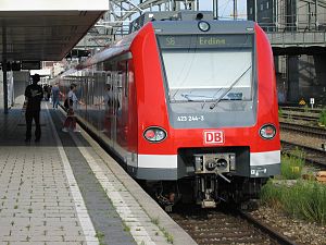
Munich S-Bahn
Electric rail transit system in Germany
Distance: Approx. 355 meters
Latitude and longitude: 48.1408,11.555
The Munich S-Bahn (German: S-Bahn München) is an electric rail transit system in Munich, Germany. "S-Bahn" is the German abbreviation for Stadtschnellbahn (literally, "urban rapid rail"), and the Munich S-Bahn exhibits characteristics of both rapid transit and commuter rail systems. The Munich S-Bahn network is operated by S-Bahn München, a subsidiary of DB Regio Bayern, which is itself a subsidiary of the German national railway company, Deutsche Bahn.

Augustiner-Bräu
Brewery in Munich, Germany
Distance: Approx. 487 meters
Latitude and longitude: 48.14305556,11.55194444
Augustiner-Bräu is a brewery in Munich, Germany, established in 1328. It is Munich's oldest independent brewery.

Bayerischer Rundfunk
Public-service radio and television broadcaster based in Munich
Distance: Approx. 483 meters
Latitude and longitude: 48.14277778,11.55361111
Bayerischer Rundfunk (pronounced [ˈbaɪʁɪʃɐ ˈʁʊntfʊŋk]; "Bavarian Broadcasting"), shortened to BR (pronounced [beːˈʔɛʁ] ), is a public-service radio and television broadcaster, based in Munich, capital city of the Free State of Bavaria in Germany. BR is a member organization of the ARD consortium of public broadcasters in Germany.

1960 Munich C-131 crash
1960 aviation disaster in Munich, West Germany
Distance: Approx. 126 meters
Latitude and longitude: 48.13888889,11.54972222
On 17 December 1960, a Convair C-131D Samaritan operated by the United States Air Force on a flight from Munich to RAF Northolt crashed shortly after take-off from Munich-Riem Airport, due to fuel contamination. All 20 passengers and crew on board as well as 32 people on the ground were killed.

München Hauptbahnhof
Main railway station in Munich, Germany
Distance: Approx. 358 meters
Latitude and longitude: 48.14083333,11.555
München Hauptbahnhof or Munich Central Station is the main railway station in the city of Munich, Germany. It is one of the three stations with long-distance services in Munich, the others being Munich East station (München Ost) and Munich-Pasing station (München-Pasing). München Hauptbahnhof sees about 450,000 passengers a day, which puts it on par with other large stations in Germany, such as Hamburg Hauptbahnhof and Frankfurt (Main) Hauptbahnhof.

Theresienwiese station
Station of the Munich U-Bahn
Distance: Approx. 295 meters
Latitude and longitude: 48.13638889,11.55333333
Theresienwiese is a station of Munich U-Bahn on the U4 and U5 line. It is the closest station to the Oktoberfest grounds on the Theresienwiese. During Oktoberfest, the station handles 21,000 passengers per hour each direction.

Munich Hackerbrücke station
Munich S-Bahn station
Distance: Approx. 416 meters
Latitude and longitude: 48.14194444,11.54861111
Munich Hackerbrücke station is a station opened in 1972 on the Munich S-Bahn network below Hackerbrücke (Hacker bridge) that is close to Munich Central Station (German: Hauptbahnhof). It is classified by Deutsche Bahn as a category 3 station and has a 211 metre long central platform between two platform tracks and is located directly in front of a 3.2 percent drop into the S-Bahn trunk line tunnel. Immediately to the south is the Munich Hauptbahnhof signal box, which monitors and controls all the track work at the Central Station and on the adjoining lines (excluding the S-Bahn).
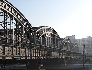
Hackerbrücke
Distance: Approx. 401 meters
Latitude and longitude: 48.14166667,11.54833333
The Hackerbrücke (Hacker Bridge) is a road bridge across the main railway line in Munich immediately west of the town's central station. The first bridge was built at the beginning of the 1870s. In 1890-94 this was replaced by a new bridge, constructed by the Maschinenfabrik Augsburg-Nürnberg ("Augsburg-Nuremberg machine factory").
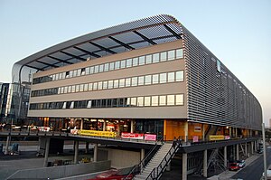
Zentraler Omnibusbahnhof München
Distance: Approx. 436 meters
Latitude and longitude: 48.1425,11.55
Zentraler Omnibusbahnhof München (ZOB München, Central bus station Munich) is a central bus station located in Maxvorstadt, Munich, Bavaria, Germany. The terminal has an area of 17,221 square metres (185,370 sq ft). The bus station was established on 11 September 2009 and is a major transportation hub for bus and train with national and international traffic.

Oktoberfest bombing
1980 neo-Nazi terrorist attack in Munich, West Germany
Distance: Approx. 333 meters
Latitude and longitude: 48.13592,11.549736
The Oktoberfest bombing (German: Oktoberfest-Attentat) was a far-right terrorist attack. On 26 September 1980, 13 people were killed (including the perpetrator) and more than 200 injured by the explosion of an improvised explosive device (IED) at the main entrance of the Oktoberfest festival in Munich, West Germany. The bombing was attributed to the right-wing extremist and geology student Gundolf Köhler, who was instantly killed in the attack as the bomb exploded prematurely.

St. Paul's Church, Munich
Catholic church in Munich, Germany
Distance: Approx. 264 meters
Latitude and longitude: 48.13638889,11.55222222
St. Paul's Church (German: St Paul or Paulskirche) is a large Catholic church in the Ludwigsvorstadt-Isarvorstadt quarter of Munich, Bavaria, Germany. It was built in 1892–1906, designed by the Austrian architect Georg von Hauberrisser in the Gothic Revival style, north of the Theresienwiese.

Forum Queeres Archiv München
Distance: Approx. 124 meters
Latitude and longitude: 48.1383325,11.5529736
The Forum Queeres Archiv München (English: Forum Queer Archive Munich - LGBTIQ* in History and Culture) in Munich, Germany, is an association and archive with collections focusing on LGBTQ+ history and culture in Munich, Bavaria and Germany. It opened in 1999 and was named forum homosexualität münchen – Lesben und Schwule in Geschichte und Kultur e.V. till 2019.
Weather in this IP's area
overcast clouds
9 Celsius
9 Celsius
7 Celsius
10 Celsius
1018 hPa
99 %
1018 hPa
956 hPa
10000 meters
0.59 m/s
0.69 m/s
115 degree
100 %
07:39:21
18:17:44