Country:
Region:
City:
Latitude and Longitude:
Time Zone:
Postal Code:
IP information under different IP Channel
ip-api
Country
Region
City
ASN
Time Zone
ISP
Blacklist
Proxy
Latitude
Longitude
Postal
Route
Luminati
Country
ASN
Time Zone
Asia/Tehran
ISP
Homaye Jahan Nama Co. ( Private Joint Stock)
Latitude
Longitude
Postal
IPinfo
Country
Region
City
ASN
Time Zone
ISP
Blacklist
Proxy
Latitude
Longitude
Postal
Route
db-ip
Country
Region
City
ASN
Time Zone
ISP
Blacklist
Proxy
Latitude
Longitude
Postal
Route
ipdata
Country
Region
City
ASN
Time Zone
ISP
Blacklist
Proxy
Latitude
Longitude
Postal
Route
Popular places and events near this IP address
Hafezieh Stadium
Stadium in Shiraz, Iran
Distance: Approx. 1430 meters
Latitude and longitude: 29.6239,52.5562
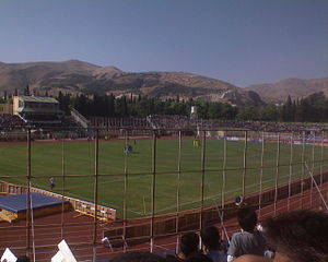
The Hafeziyeh Stadium (Persian: ورزشگاه حافظیه) is a multi-purpose stadium in Shiraz, Iran. It is currently used mostly for football matches and is the home stadium of Persian Gulf League side, Fajr Sepasi F.C. The stadium also is used for some matches of Bargh Shiraz F.C. in Azadegan League. The stadium holds 20,000 people and is all-seater.

Arg of Karim Khan
Citadel in Shiraz, Iranian national heritage site
Distance: Approx. 1254 meters
Latitude and longitude: 29.6174,52.5446
The Arg of Karim Khan (Persian: ارگ کریم خان, Arg-e Karim Khān) or Karim Khan Citadel, is a citadel located in downtown Shiraz, Iran. It was built as part of a complex during the Zand dynasty. It is named after Karim Khan, and served as his living quarters.

Vakil Bazaar
Building in Shiraz, Iran
Distance: Approx. 1564 meters
Latitude and longitude: 29.61498056,52.54679722
Vakil Bazaar (Persian: بازار وکیل) is a bazaar of Shiraz, Iran, located in the center of the city.

Vakil Bathhouse
Old public bath in Shiraz, Iran
Distance: Approx. 1551 meters
Latitude and longitude: 29.61477,52.54512
Vakil Bath, Wakil Bath, or Wakil Hammam (Persian: حمام وکیل) is an old public bathhouse (hammam) in Shiraz, Iran. It was a part of the royal district constructed during Karim Khan Zand's reign (1751–1779) which includes the Arg of Karim Khan, Vakil Bazaar, Vakil Mosque and many administrative buildings. It is located on the west side of the Vakil Mosque.
Pars Museum
Distance: Approx. 1413 meters
Latitude and longitude: 29.61600833,52.545
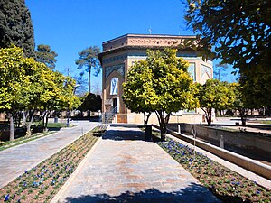
The Pars Museum (Persian: موزه پارس) is a museum in Shiraz, Fars Province, southern Iran. Founded in 1936 under Reza Shah Pahlavi, it is located in Nazar Garden. The octagonal building was the place in which royal guests were hosted during the Zand dynasty of Iran.

Tomb of Hafez
Memorial structure in Shiraz, Iran
Distance: Approx. 1579 meters
Latitude and longitude: 29.62540278,52.55831944
The Tomb of Hafez (Persian: آرامگاه حافظ), commonly known as Hāfezieh (حافظیه), are two memorial structures erected in the northern edge of Shiraz, Iran, in memory of the celebrated Persian poet Hafez. The open pavilion structures are situated in the Musalla Gardens on the north bank of a seasonal river and house the marble tomb of Hafez. The present buildings, built in 1935 and designed by the French architect and archaeologist André Godard, are at the site of previous structures, the best-known of which was built in 1773.

Vakil Mosque
Mosque in Shiraz, Iranian national heritage site
Distance: Approx. 1618 meters
Latitude and longitude: 29.61416944,52.54516667
The Vakil Mosque (Persian: مسجد وکیل – Masjed-e Vakil) is a mosque in Shiraz, southern Iran, situated to the west of the Vakil Bazaar next to its entrance. This mosque was built between 1751 and 1773, during the Zand period; however, it was restored in the 19th century during the Qajar period. Vakil means regent, which was the title used by Karim Khan, the founder of Zand dynasty.

Shapouri House
Distance: Approx. 1231 meters
Latitude and longitude: 29.61877778,52.53633611
Shapouri House or Shapouri Pavilion and Garden (Persian:خانه شاپوری) is an early 20th-century Iranian building and garden in the city of Shiraz, Iran. It has 840 square metres of underpinning and 4635 square metres of garden area, and it is built on two floors. This building is in the old central region of Shiraz, known as Anvari.
Jameh Mosque of Qiblah
Mosque in Kukherd city, Iran
Distance: Approx. 1618 meters
Latitude and longitude: 29.61416944,52.54516667
The Jameh Mosque of Qiblah (Arabic: مسجد جامع قبلة; Persian: مسجد جامع قبله – Masjed-e Qiblah) is a mosque in Kukherd city, the capital of Kukherd District in Bastak County, Hormozgan Province, Iran.
Shohada-ye Haftom-e Tir Stadium (Babol)
Distance: Approx. 1583 meters
Latitude and longitude: 29.61666667,52.53333333
Shohada-ye Haftom-e Tir Stadium of Babol is a stadium on Babol, Iran. It is owned by the government Physical Education Organization and has a seating capacity of 6,000. Its primary tenant is F.C. Rayka Babol.
Shahid Dastgheib Hospital
Hospital in Shiraz, Iran
Distance: Approx. 1287 meters
Latitude and longitude: 29.624172,52.554738
Shahid Dastgheib Hospital is a public hospital located in Shiraz, Iran and currently has a capacity of 130 beds.

Church of St. Simon the Zealot
Iranian national heritage site
Distance: Approx. 1205 meters
Latitude and longitude: 29.61988272,52.53486961
Church of Simon the Zealot, is an Anglican church in Shiraz, Iran. It is located on Zand Avenue in Shiraz, next to Shiraz Christian Mission Hospital.
Weather in this IP's area
clear sky
22 Celsius
21 Celsius
22 Celsius
22 Celsius
1020 hPa
40 %
1020 hPa
855 hPa
10000 meters
06:18:45
17:08:29

