Country:
Region:
City:
Latitude and Longitude:
Time Zone:
Postal Code:
IP information under different IP Channel
ip-api
Country
Region
City
ASN
Time Zone
ISP
Blacklist
Proxy
Latitude
Longitude
Postal
Route
Luminati
Country
Region
hdf
City
boves
ASN
Time Zone
Europe/Paris
ISP
Neuronnexion
Latitude
Longitude
Postal
IPinfo
Country
Region
City
ASN
Time Zone
ISP
Blacklist
Proxy
Latitude
Longitude
Postal
Route
db-ip
Country
Region
City
ASN
Time Zone
ISP
Blacklist
Proxy
Latitude
Longitude
Postal
Route
ipdata
Country
Region
City
ASN
Time Zone
ISP
Blacklist
Proxy
Latitude
Longitude
Postal
Route
Popular places and events near this IP address

Noye
River in France
Distance: Approx. 1486 meters
Latitude and longitude: 49.85222222,2.37888889
The Noye (French pronunciation: [nwa]; Picard: Noée) is a river in the Hauts-de-France region of northern France. The Noye is located in the northern part of the Picard plateau. It is the left tributary of the Avre river, which is itself a left tributary of the Somme.

Glisy
Commune in Hauts-de-France, France
Distance: Approx. 3960 meters
Latitude and longitude: 49.8783,2.3992
Glisy (French pronunciation: [ɡlizi]; Picard: Glisu) is a commune in the Somme department in Hauts-de-France in northern France.

Longueau station
Distance: Approx. 3772 meters
Latitude and longitude: 49.86416667,2.35277778
Longueau station (French: Gare de Longueau) is a railway station in Longueau near Amiens, France. It is situated on the Paris–Lille railway. Longueau is served by trains of the TER Hauts-de-France network.
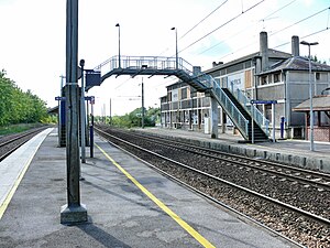
Boves station
Distance: Approx. 475 meters
Latitude and longitude: 49.84611111,2.39805556
Boves is a railway station located in Boves, France. It is situated on the Paris–Lille railway. It is served by regional TER Hauts-de-France trains from Amiens to Creil and Compiègne.

Boves, Somme
Commune in Hauts-de-France, France
Distance: Approx. 384 meters
Latitude and longitude: 49.8461,2.3917
Boves (French pronunciation: [bɔv]; Picard: Bofe) is a commune in the Somme department in Hauts-de-France in northern France.
Cottenchy
Commune in Hauts-de-France, France
Distance: Approx. 3738 meters
Latitude and longitude: 49.81,2.3833
Cottenchy (French pronunciation: [kɔtɑ̃ʃi]; Picard: Cotinchy) is a commune in the Somme department in Hauts-de-France in northern France.
Fouencamps
Commune in Hauts-de-France, France
Distance: Approx. 2184 meters
Latitude and longitude: 49.8258,2.4086
Fouencamps (French pronunciation: [fwɛ̃kɑ̃]; Picard: Flencamp) is a commune in the Somme department in Hauts-de-France in northern France.

Longueau
Commune in Hauts-de-France, France
Distance: Approx. 4077 meters
Latitude and longitude: 49.8708,2.3569
Longueau (French pronunciation: [lɔ̃ɡo]; Picard: Londjeu) is a commune in the Somme department in Hauts-de-France in northern France.
Canton of Boves
Former canton in Hauts-de-France, France
Distance: Approx. 386 meters
Latitude and longitude: 49.84611111,2.39166667
The Canton of Boves is a former canton situated in the department of the Somme and in the former Picardy region of northern France. It was disbanded following the French canton reorganisation which came into effect in March 2015. It had 20,790 inhabitants (2012).

Amiens – Glisy Aerodrome
Airport in Glisy
Distance: Approx. 3392 meters
Latitude and longitude: 49.87305556,2.38694444
Amiens – Glisy Aerodrome (French: Aérodrome d'Amiens - Glisy, ICAO: LFAY) is an airport serving Amiens, the capital city of the Somme department of the Picardy (Picardie) region in France. The airport is located 7 km (4 mi) east-southeast of Amiens, in Glisy. The airport is used for general aviation, with no commercial airline service.

Longueau–Boulogne railway
French railway
Distance: Approx. 3820 meters
Latitude and longitude: 49.8643,2.3521
The Longueau–Boulogne railway is a French railway which runs from a junction with the Paris-Lille railway at Longueau to the coastal port of Boulogne. A double track railway it is 171 kilometres (106 miles) long. Until the start of the Eurostar service from London to Paris in 1994 via LGV Nord it was the main route for the boat trains to Paris which met the ships carrying passengers from Great Britain.

Longueau British Cemetery
Cemetery located in Somme, France
Distance: Approx. 3847 meters
Latitude and longitude: 49.8694,2.3593
Longueau British Cemetery is a First World War cemetery of Commonwealth soldiers in France, located to the east of Longueau, a suburb south-east of Amiens, Somme, France. The cemetery was begun in April 1918 and contains 204 burials, 14 of which are unidentified. Two Second World War airmen are also interred in the cemetery.
Weather in this IP's area
light rain
8 Celsius
4 Celsius
7 Celsius
8 Celsius
1011 hPa
94 %
1011 hPa
1007 hPa
10000 meters
5.67 m/s
11.15 m/s
247 degree
100 %
08:08:04
17:03:34


