Country:
 France
Region:
City:
Latitude and Longitude:
Time Zone:
Postal Code:
IP information under different IP Channel
ip-api
Country
Region
City
ASN
Time Zone
ISP
Blacklist
Proxy
Latitude
Longitude
Postal
Route
IPinfo
Country
Region
City
ASN
Time Zone
ISP
Blacklist
Proxy
Latitude
Longitude
Postal
Route
MaxMind
Country
Region
City
ASN
Time Zone
ISP
Blacklist
Proxy
Latitude
Longitude
Postal
Route
Luminati
Country
FRRegion
cvl
City
tours
ASN
Time Zone
Europe/Paris
ISP
Scaleway S.a.s.
Latitude
Longitude
Postal
db-ip
Country
Region
City
ASN
Time Zone
ISP
Blacklist
Proxy
Latitude
Longitude
Postal
Route
ipdata
Country
Region
City
ASN
Time Zone
ISP
Blacklist
Proxy
Latitude
Longitude
Postal
Route
Popular places and events near this IP address

Tours
City in Centre-Val de Loire, France
Distance: Approx. 1213 meters
Latitude and longitude: 47.393611,0.689167
Tours ( TOOR, French: [tuʁ] ) is the largest city in the region of Centre-Val de Loire, France. It is the prefecture of the department of Indre-et-Loire. The commune of Tours had 136,463 inhabitants as of 2018 while the population of the whole metropolitan area was 516,973.
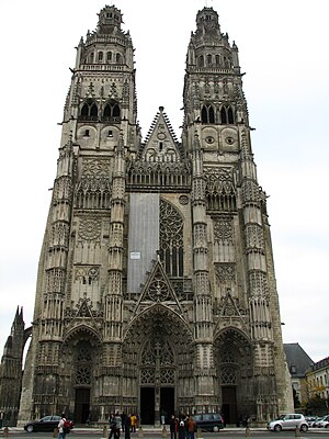
Roman Catholic Archdiocese of Tours
Catholic archdiocese in France
Distance: Approx. 1050 meters
Latitude and longitude: 47.4,0.69
The Archdiocese of Tours (Latin: Archidioecesis Turonensis; French: Archidiocèse de Tours) is a Latin Church archdiocese of the Catholic Church in France. The archdiocese has roots that go back to the 3rd century, while the formal erection of the diocese dates from the 5th century. The ecclesiastical province of Tours corresponds with the late Roman province of Tertia Lugdunensis.
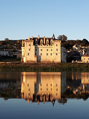
Châteaux of the Loire Valley
Historic grand residences in a part of France
Distance: Approx. 96 meters
Latitude and longitude: 47.39888889,0.70277778
The châteaux of the Loire Valley (French: châteaux de la Loire) are part of the architectural heritage of the historic towns of Amboise, Angers, Blois, Chinon, Montsoreau, Orléans, Saumur, and Tours along the river Loire in France. They illustrate Renaissance ideals of design in France. The châteaux of the Loire Valley number over three hundred, ranging from practical fortified castles from the 10th century to splendid residences built half a millennium later.

Marmoutier Abbey, Tours
Distance: Approx. 1148 meters
Latitude and longitude: 47.40305556,0.71722222
Marmoutier Abbey — also known as the Abbey of Marmoutier or Marmoutiers — was an early monastery outside Tours, Indre-et-Loire, France. In its later days it followed the Benedictine order as an influential monastery with many dependencies.
Oratory of the Holy Face
Roman Catholic oratory in Tours, France
Distance: Approx. 941 meters
Latitude and longitude: 47.393865,0.693072
The Oratory of the Holy Face is a Roman Catholic oratory in Tours France. It was originally established on the Rue St. Etienne, in the former home of Venerable Leo Dupont who did much to promote devotion to the Holy Face of Jesus.

Tours station
Railway station serving the city of Tours, France
Distance: Approx. 1221 meters
Latitude and longitude: 47.38972222,0.69361111
Tours station (French: Gare de Tours) is a railway station serving the city of Tours, Indre-et-Loire department, western France. It is situated on the Paris–Bordeaux railway, the Tours–Saint-Nazaire railway, and the non-electrified Tours–Le Mans railway. The Gare de Tours is a terminus; most TGV trains only serve the nearby Gare de Saint-Pierre-des-Corps.
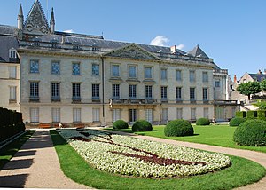
Musée des Beaux-Arts de Tours
Art museum in Place Francis Sicard, Tours
Distance: Approx. 748 meters
Latitude and longitude: 47.3952,0.6949
The Musée des Beaux-Arts de Tours (English: Museum of Fine Arts of Tours) is located in the bishop's former palace, near the cathedral St. Gatien, where it has been since 1910. It displays rich and varied collections, including that of painting which is one of the first in France both in quality and the diversity of the works presented.

Château de Tours
Castle in Tours, France
Distance: Approx. 773 meters
Latitude and longitude: 47.3971,0.6936
The Château de Tours is a castle located in Tours, Indre-et-Loire, France. Built in the 11th century, the building features architecture of the Carolingian period, and was the residence of the Lords of France. Until the 2000s, the Royal Castle of Tours was used as an aquarium where about 1,500 fish of 200 different species could be seen.

Tours Amphitheatre
Roman amphitheatre in France
Distance: Approx. 669 meters
Latitude and longitude: 47.39542222,0.69590278
The Tours amphitheater (also known as the Caesarodunum amphitheater) is a Roman amphitheatre located in the historic city center of Tours, France, immediately behind the well known Tours cathedral. It was built in the 1st century when the city was called Caesarodunum. It was built atop a small hill on the outskirts of the ancient urban area, making it safe from floods, convenient for crowds and visitors, and demonstrating the power of the city from a distance.
Cantons of Tours
Distance: Approx. 1385 meters
Latitude and longitude: 47.39,0.69
The cantons of Tours are administrative divisions of the Indre-et-Loire department, in central France. Since the French canton reorganisation which came into effect in March 2015, the city of Tours is subdivided into 4 cantons. Their seat is in Tours.

Hôtel de Ville, Tours
Town hall of Tours, France
Distance: Approx. 1377 meters
Latitude and longitude: 47.39065,0.68934
The Hôtel de Ville (French pronunciation: [otɛl də vil], City Hall) in Tours, France houses the city's offices. The building, ornate inside and out, was designed by Tours native architect Victor Laloux and completed in 1904. It was designated a monument historique by the French government in 1975.

Arcis enclosure
11th century urban enclosure in Tours, France
Distance: Approx. 899 meters
Latitude and longitude: 47.39611111,0.69222222
The Arcis enclosure (Enceinte des Arcis, in French) is an urban enclosure in the French commune of Tours in the Indre-et-Loire department. It was built against the western flank of the city's Gallo-Roman enclosure to extend the walled perimeter. Its construction undoubtedly dates back to the 11th or 12th century, after the building of the bridge over the Loire that ends in its northeast corner, but sources on its subject are scarce.
Weather in this IP's area
overcast clouds
16 Celsius
16 Celsius
16 Celsius
16 Celsius
1016 hPa
76 %
1016 hPa
1010 hPa
10000 meters
4.12 m/s
300 degree
100 %
08:20:13
19:04:00