Country:
 Germany
Region:
City:
Latitude and Longitude:
Time Zone:
Postal Code:
IP information under different IP Channel
ip-api
Country
Region
City
ASN
Time Zone
ISP
Blacklist
Proxy
Latitude
Longitude
Postal
Route
IPinfo
Country
Region
City
ASN
Time Zone
ISP
Blacklist
Proxy
Latitude
Longitude
Postal
Route
MaxMind
Country
Region
City
ASN
Time Zone
ISP
Blacklist
Proxy
Latitude
Longitude
Postal
Route
Luminati
Country
DEASN
Time Zone
Europe/Berlin
ISP
INCAS GmbH
Latitude
Longitude
Postal
db-ip
Country
Region
City
ASN
Time Zone
ISP
Blacklist
Proxy
Latitude
Longitude
Postal
Route
ipdata
Country
Region
City
ASN
Time Zone
ISP
Blacklist
Proxy
Latitude
Longitude
Postal
Route
Popular places and events near this IP address
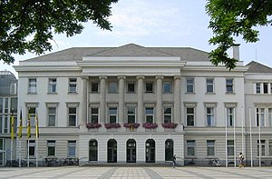
Krefeld
City in North Rhine-Westphalia, Germany
Distance: Approx. 4338 meters
Latitude and longitude: 51.33333333,6.56666667
Krefeld ( KRAY-feld, -felt, German: [ˈkʁeːfɛlt] ; Limburgish: Krieëvel [ˈkʀiə˦vəl]), also spelled Crefeld until 1925 (though the spelling was still being used in British papers throughout the Second World War), is a city in North Rhine-Westphalia, Germany. It is located northwest of Düsseldorf, its center lying just a few kilometers to the west of the river Rhine; the borough of Uerdingen is situated directly on the Rhine. Because of its economic past, Krefeld is often referred to as the "Velvet and Silk City".
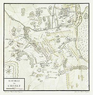
Battle of Krefeld
1758 battle of the Seven Years' War
Distance: Approx. 3822 meters
Latitude and longitude: 51.3028,6.5109
The Battle of Krefeld (sometimes referred to by its French name of Créfeld) was fought at Krefeld near the Rhine on 23 June 1758 between a Prussian-Hanoverian army and a French army during the Seven Years' War.

Willich
Town in North Rhine-Westphalia, Germany
Distance: Approx. 3642 meters
Latitude and longitude: 51.26305556,6.54916667
Willich (German pronunciation: [ˈvɪlɪç] ) is a town in the district of Viersen, in North Rhine-Westphalia, Germany. It is 20 km west of Düsseldorf, 14 km north of Mönchengladbach, 10 km south of Krefeld, about 30 kilometres east of the border with the Netherlands and 45 km east of Roermond.

Fischeln
Distance: Approx. 1474 meters
Latitude and longitude: 51.3,6.58333333
Fischeln is the most southerly district of Krefeld, Germany. Its population is 26,030 (2019) and its area is 18.99 km2 (7.33 sq mi). Older than Krefeld, Fischeln was first mentioned as "Viscolo" around 900AD. Fischeln became a district of Krefeld in 1929.
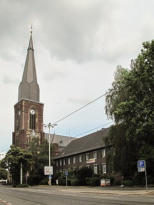
Bockum
Stadtteil of Krefeld in North Rhine-Westphalia, Germany
Distance: Approx. 4338 meters
Latitude and longitude: 51.33333333,6.56666667
Bockum is a northeastern district of Krefeld, North Rhine-Westphalia, Germany. With its large parks, its advantageous location and high housing comfort, it is one of the most favoured residential areas in the city. The center of Bockum is marked by the neogothic church of St.
Forstwald
Distance: Approx. 4680 meters
Latitude and longitude: 51.3,6.4975
Forstwald is a quarter (Stadtteil) of Krefeld, western Germany, located to the west of the main city center. It is marked by its forest landscape and more up-scale housing than other regions of Krefeld. Its population is 3,545 (2019) and its area is 4.12 km2 (1.59 sq mi).

Botanischer Garten Krefeld
Distance: Approx. 5032 meters
Latitude and longitude: 51.3325,6.60305556
The Botanischer Garten Krefeld (3.6 hectares), more formally the Botanischer Garten der Stadt Krefeld, is a municipal botanical garden located at Sandberg 2, Krefeld, North Rhine-Westphalia, Germany. It is open daily in the warmer months; admission is free. The garden was established in 1927–1928 as part of a small school.

Krefeld Hauptbahnhof
Railway station in Krefeld, Germany
Distance: Approx. 3519 meters
Latitude and longitude: 51.32583333,6.56944444
Krefeld Hauptbahnhof is the largest station of the city of Krefeld in the German state of North Rhine-Westphalia. The double-track and electrified Duisburg-Ruhrort–Mönchengladbach railway (KBS 425) and the Lower Left Rhine Railway (KBS 495) cross at the station.

Fabrik Heeder
Architectural structure
Distance: Approx. 3231 meters
Latitude and longitude: 51.322983,6.572236
Fabrik Heeder is a theatre in Krefeld, North Rhine-Westphalia, Germany. It is a former factory building, originally constructed in 1906, and has been in use for cultural activities since 1989.
Krieewelsche Pappköpp
Distance: Approx. 4294 meters
Latitude and longitude: 51.33083333,6.54388889
Krieewelsche pappköpp is a theatre in Krefeld, North Rhine-Westphalia, Germany.

TAM (theatre)
Theatre in Krefeld, Germany
Distance: Approx. 1817 meters
Latitude and longitude: 51.30444444,6.58472222
TAM (Theater) is a theatre in Krefeld, North Rhine-Westphalia, Germany.

Trams in Krefeld
Part of the public transport system in Krefeld, Germany
Distance: Approx. 4367 meters
Latitude and longitude: 51.33361111,6.56583333
The Krefeld tramway network (German: Straßenbahnnetz Krefeld) is a network of tramways forming part of the public transport system in Krefeld, a city in the federal state of North Rhine-Westphalia, Germany. Opened in 1883, the network has been operated since 2002 by SWK MOBIL, and is integrated in the Verkehrsverbund Rhein-Ruhr (VRR).
Weather in this IP's area
broken clouds
14 Celsius
14 Celsius
13 Celsius
15 Celsius
1019 hPa
85 %
1019 hPa
1014 hPa
10000 meters
5.14 m/s
170 degree
75 %
08:04:29
18:32:30