Country:
Region:
City:
Latitude and Longitude:
Time Zone:
Postal Code:
IP information under different IP Channel
ip-api
Country
Region
City
ASN
Time Zone
ISP
Blacklist
Proxy
Latitude
Longitude
Postal
Route
Luminati
Country
Region
ge
City
geneva
ASN
Time Zone
Europe/Zurich
ISP
IP worldcom SA
Latitude
Longitude
Postal
IPinfo
Country
Region
City
ASN
Time Zone
ISP
Blacklist
Proxy
Latitude
Longitude
Postal
Route
db-ip
Country
Region
City
ASN
Time Zone
ISP
Blacklist
Proxy
Latitude
Longitude
Postal
Route
ipdata
Country
Region
City
ASN
Time Zone
ISP
Blacklist
Proxy
Latitude
Longitude
Postal
Route
Popular places and events near this IP address
Chexbres
Municipality in Vaud, Switzerland
Distance: Approx. 2585 meters
Latitude and longitude: 46.48333333,6.76666667
Chexbres (pronounced [ʃɛbʁ] SHEB-r) is a municipality in the Swiss canton of Vaud, located in the district of Lavaux-Oron. Chexbres is a wine-growing village and enjoys a good selection of local vintages. It also enjoys notable views of Lake Geneva, and therefore is nicknamed "Balcon du Léman" in French.

Epesses
Former municipality in Vaud, Switzerland
Distance: Approx. 2370 meters
Latitude and longitude: 46.5,6.75
Epesses is a former municipality in the Swiss canton of Vaud, located in the district of Lavaux-Oron on Lake Geneva. It is noted for its wine production. The municipalities of Cully, Epesses, Grandvaux, Riex and Villette (Lavaux) merged on 1 July 2011 into the new municipality of Bourg-en-Lavaux.
Puidoux
Municipality in Vaud, Switzerland
Distance: Approx. 2585 meters
Latitude and longitude: 46.48333333,6.76666667
Puidoux (French pronunciation: [pɥidu] ) is a municipality in Switzerland in the canton of Vaud, located in the district of Lavaux-Oron.

Lavaux District
District in Switzerland
Distance: Approx. 2370 meters
Latitude and longitude: 46.5,6.75
Lavaux District was a district located on the north-eastern shore of Lake Geneva (Lac Léman) in the Swiss-romand canton of Vaud between Lausanne and Vevey. The capital of the district was Cully, but used to be Lutry. The district is part of the World Heritage Site listed region of Lavaux.
Treytorrens, Lavaux
Distance: Approx. 2965 meters
Latitude and longitude: 46.48472222,6.75444444
Treytorrens is a village in the commune of Puidoux in the district of Lavaux and is located in the canton of Vaud.

Lavaux
UNESCO World Heritage Site in Canton of Vaud, Switzerland
Distance: Approx. 2968 meters
Latitude and longitude: 46.49194444,6.74611111
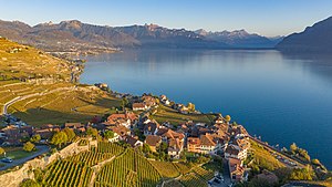
Lavaux (French pronunciation: [lavo]) is a region in the canton of Vaud in Switzerland, in the district of Lavaux-Oron. Lavaux consists of 830 hectares of terraced vineyards that stretch for about 30 km along the south-facing northern shores of Lake Geneva. Although there is some evidence that vines were grown in the area in Roman times, the actual vine terraces can be traced back to the 11th century, when Benedictine and Cistercian monasteries controlled the area.

Lac de Bret
Natural lake, eutrophic in Puidoux, Vaud
Distance: Approx. 948 meters
Latitude and longitude: 46.51111111,6.77222222
Lac de Bret is a lake in the municipality of Puidoux, in the canton of Vaud, Switzerland. It is located north of Lake Geneva. The natural lake is used as a drinking water reservoir for the city of Lausanne.

Mont Pèlerin TV Tower
Distance: Approx. 3082 meters
Latitude and longitude: 46.4971,6.81891944
The Mont Pèlerin TV Tower is a transmission tower situated on Mont Pèlerin in the area of Chardonne, north of Vevey and is the only TV tower of Switzerland equipped with an observation deck, which is accessible by an elevator. Including this mast, the height of the tower is 122.6 metres.
Mont Pèlerin
Mountain of the Swiss Plateau
Distance: Approx. 3105 meters
Latitude and longitude: 46.49694444,6.81916667
Mont Pèlerin (; French: [mɔ̃ pɛlʁɛ̃]; 1,080 metres (3,540 ft)) is a mountain of the Swiss Plateau, overlooking Lake Geneva in the canton of Vaud. It lies north of Chardonne, over Vevey, the border with the canton of Fribourg running at the eastern foot of the mountain. The Vevey–Chardonne–Mont Pèlerin funicular links Vevey and Mont Pèlerin.

Puidoux railway station
Railway station in Puidoux, Switzerland
Distance: Approx. 1635 meters
Latitude and longitude: 46.493835,6.765685
Puidoux railway station (French: Gare de Puidoux), also known as Puidoux-Chexbres railway station (until 2018), is a railway station in the municipality of Puidoux, in the Swiss canton of Vaud. It is an intermediate stop on the standard gauge Lausanne–Bern line and the western terminus of the Vevey–Chexbres line, both owned by Swiss Federal Railways. Before Chexbres-Village railway station was opened nearby in 1904, it was known as Chexbres railway station.

Moreillon railway station
Railway station in Puidoux, Switzerland
Distance: Approx. 593 meters
Latitude and longitude: 46.508385,6.785645
Moreillon railway station (French: Gare de Moreillon) is a railway station in the municipality of Puidoux, in the Swiss canton of Vaud. It is an intermediate stop on the standard gauge Lausanne–Bern line of Swiss Federal Railways.

Chexbres-Village railway station
Railway station in Chexbres, Switzerland
Distance: Approx. 2624 meters
Latitude and longitude: 46.481056,6.77854539
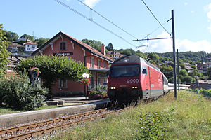
Chexbres-Village railway station (French: Gare de Chexbres-Village) is a railway station in the municipality of Chexbres, in the Swiss canton of Vaud. It is an intermediate stop on the standard gauge Vevey–Chexbres line of Swiss Federal Railways.
Weather in this IP's area
overcast clouds
14 Celsius
13 Celsius
12 Celsius
15 Celsius
1026 hPa
59 %
1026 hPa
949 hPa
10000 meters
1.16 m/s
0.77 m/s
327 degree
97 %
07:17:42
17:15:06


