Country:
 Switzerland
Region:
City:
Latitude and Longitude:
Time Zone:
Postal Code:
IP information under different IP Channel
ip-api
Country
Region
City
ASN
Time Zone
ISP
Blacklist
Proxy
Latitude
Longitude
Postal
Route
IPinfo
Country
Region
City
ASN
Time Zone
ISP
Blacklist
Proxy
Latitude
Longitude
Postal
Route
MaxMind
Country
Region
City
ASN
Time Zone
ISP
Blacklist
Proxy
Latitude
Longitude
Postal
Route
Luminati
Country
CHASN
Time Zone
Europe/Zurich
ISP
IP worldcom SA
Latitude
Longitude
Postal
db-ip
Country
Region
City
ASN
Time Zone
ISP
Blacklist
Proxy
Latitude
Longitude
Postal
Route
ipdata
Country
Region
City
ASN
Time Zone
ISP
Blacklist
Proxy
Latitude
Longitude
Postal
Route
Popular places and events near this IP address

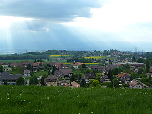
Cheseaux-sur-Lausanne
Municipality in Vaud, Switzerland
Distance: Approx. 2472 meters
Latitude and longitude: 46.58333333,6.6
Cheseaux-sur-Lausanne (French pronunciation: [ʃəzo syʁ lɔzan] , literally Cheseaux on Lausanne; Arpitan: Chesâls) is a municipality in the district of Lausanne in the canton of Vaud in Switzerland. It is a suburb of the city of Lausanne.

Romanel-sur-Lausanne
Municipality in Vaud, Switzerland
Distance: Approx. 2603 meters
Latitude and longitude: 46.56666667,6.6
Romanel-sur-Lausanne (French pronunciation: [ʁɔmanɛl syʁ lɔzan] , literally Romanel on Lausanne; Arpitan: Romanél) is a municipality in the canton of Vaud in Switzerland, located in the district of Lausanne.
Cugy, Vaud
Municipality in Vaud, Switzerland
Distance: Approx. 774 meters
Latitude and longitude: 46.58333333,6.63333333
Cugy is a municipality in the district of Gros-de-Vaud in the canton of Vaud in Switzerland.

Bretigny-sur-Morrens
Municipality in Vaud, Switzerland
Distance: Approx. 2612 meters
Latitude and longitude: 46.6,6.63333333
Bretigny-sur-Morrens (French pronunciation: [bʁətiɲi syʁ mɔʁɑ̃] , literally Bretigny on Morrens) is a municipality in the district of Gros-de-Vaud in the canton of Vaud in Switzerland.

Étagnières
Municipality in Vaud, Switzerland
Distance: Approx. 2820 meters
Latitude and longitude: 46.6,6.61666667
Étagnières is a municipality in the district of Gros-de-Vaud in the canton of Vaud in Switzerland.

Morrens
Municipality in Vaud, Switzerland
Distance: Approx. 774 meters
Latitude and longitude: 46.58333333,6.63333333
Morrens (French pronunciation: [mɔʁɑ̃] ) is a municipality in the district of Gros-de-Vaud in the canton of Vaud in Switzerland.

Terre des hommes
Children's rights charity
Distance: Approx. 403 meters
Latitude and longitude: 46.57305556,6.62972222
Terre des hommes (pronounced [tɛʁ dez‿ɔm]; French for 'Land of People' / 'Land of Men'), also capitalized as Terre des Hommes, is an international children's rights charitable humanitarian umbrella organization under the aegis of the International Federation of Terre des Hommes (TDHIF), with independent organizations in Canada, Denmark, France, Germany, Italy, Luxembourg, the Netherlands, Switzerland, Spain, and Syria. It was founded in 1960 by Edmond Kaiser in Lausanne, Switzerland. The organization is named after Antoine de Saint-Exupéry's 1939 philosophical memoir Terre des hommes (English title: Wind, Sand and Stars).
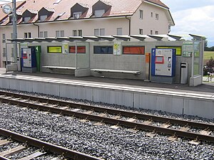
Romanel-sur-Lausanne railway station
Railway station in Romanel-sur-Lausanne, Switzerland
Distance: Approx. 2635 meters
Latitude and longitude: 46.56247,6.60317
Romanel-sur-Lausanne railway station (French: Gare de Romanel-sur-Lausanne) is a railway station in the municipality of Romanel-sur-Lausanne, in the Swiss canton of Vaud. It is located on the 1,000 mm (3 ft 3+3⁄8 in) Lausanne–Bercher line of the Chemin de fer Lausanne-Échallens-Bercher (LEB).
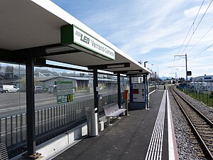
Vernand-Camarès railway station
Railway station in Lausanne, Switzerland
Distance: Approx. 2086 meters
Latitude and longitude: 46.57093889,6.6048
Vernand-Camarès railway station (French: Halte de Vernand-Camarès) is a railway station in the municipality of Lausanne, in the Swiss canton of Vaud. It is located on the 1,000 mm (3 ft 3+3⁄8 in) Lausanne–Bercher line of the Chemin de fer Lausanne-Échallens-Bercher (LEB). Although located in Lausanne, Vernand-Camarès and neighboring Bel-Air LEB are part of the Vernand exclave, some distance from the city itself.
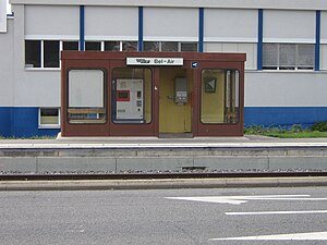
Bel-Air LEB railway station
Railway station in Lausanne, Switzerland
Distance: Approx. 1947 meters
Latitude and longitude: 46.57868056,6.60553056
Bel-Air LEB railway station (French: Halte de Bel-Air LEB) is a railway station in the municipality of Lausanne, in the Swiss canton of Vaud. It is located on the 1,000 mm (3 ft 3+3⁄8 in) Lausanne–Bercher line of the Chemin de fer Lausanne-Échallens-Bercher (LEB). Although located in Lausanne, Bel-Air LEB and neighboring Vernand-Camarès are part of the Vernand exclave, some distance from the city itself.
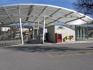
Cheseaux railway station
Railway station in Cheseaux-sur-Lausanne, Switzerland
Distance: Approx. 2086 meters
Latitude and longitude: 46.5844,6.606
Cheseaux railway station (French: Gare de Cheseaux) is a railway station in the municipality of Cheseaux-sur-Lausanne, in the Swiss canton of Vaud. It is located on the 1,000 mm (3 ft 3+3⁄8 in) Lausanne–Bercher line of the Chemin de fer Lausanne-Échallens-Bercher (LEB).
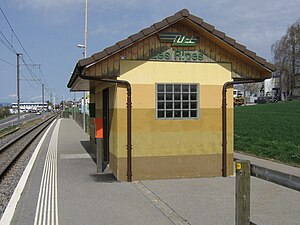
Les Ripes railway station
Railway station in Étagnières, Switzerland
Distance: Approx. 2457 meters
Latitude and longitude: 46.59219,6.60806
Les Ripes railway station (French: Halte Les Ripes) is a railway station in the municipality of Étagnières, in the Swiss canton of Vaud. It is located on the 1,000 mm (3 ft 3+3⁄8 in) Lausanne–Bercher line of the Chemin de fer Lausanne-Échallens-Bercher (LEB).
Weather in this IP's area
overcast clouds
11 Celsius
11 Celsius
10 Celsius
12 Celsius
1021 hPa
85 %
1021 hPa
940 hPa
10000 meters
6.64 m/s
11.84 m/s
31 degree
98 %
07:12:59
19:43:41