Country:
Region:
City:
Latitude and Longitude:
Time Zone:
Postal Code:
IP information under different IP Channel
ip-api
Country
Region
City
ASN
Time Zone
ISP
Blacklist
Proxy
Latitude
Longitude
Postal
Route
Luminati
Country
ASN
Time Zone
Europe/Zurich
ISP
IP worldcom SA
Latitude
Longitude
Postal
IPinfo
Country
Region
City
ASN
Time Zone
ISP
Blacklist
Proxy
Latitude
Longitude
Postal
Route
db-ip
Country
Region
City
ASN
Time Zone
ISP
Blacklist
Proxy
Latitude
Longitude
Postal
Route
ipdata
Country
Region
City
ASN
Time Zone
ISP
Blacklist
Proxy
Latitude
Longitude
Postal
Route
Popular places and events near this IP address
Chexbres
Municipality in Vaud, Switzerland
Distance: Approx. 577 meters
Latitude and longitude: 46.48333333,6.76666667
Chexbres (pronounced [ʃɛbʁ] SHEB-r) is a municipality in the Swiss canton of Vaud, located in the district of Lavaux-Oron. Chexbres is a wine-growing village and enjoys a good selection of local vintages. It also enjoys notable views of Lake Geneva, and therefore is nicknamed "Balcon du Léman" in French.
Puidoux
Municipality in Vaud, Switzerland
Distance: Approx. 577 meters
Latitude and longitude: 46.48333333,6.76666667
Puidoux (French pronunciation: [pɥidu] ) is a municipality in Switzerland in the canton of Vaud, located in the district of Lavaux-Oron.

Rivaz
Municipality in Vaud, Switzerland
Distance: Approx. 1036 meters
Latitude and longitude: 46.47628333,6.77853333
Rivaz (French pronunciation: [ʁiva] ) is a municipality in the canton of Vaud in Switzerland, located in the district of Lavaux-Oron.
Treytorrens, Lavaux
Distance: Approx. 1483 meters
Latitude and longitude: 46.48472222,6.75444444
Treytorrens is a village in the commune of Puidoux in the district of Lavaux and is located in the canton of Vaud.
Glérolles Castle
Castle in Saint-Saphorin, Switzerland
Distance: Approx. 1548 meters
Latitude and longitude: 46.47444444,6.78694444
Glérolles Castle (French: Château de Glérolles) is situated in the municipality of Saint-Saphorin, canton of Vaud, Switzerland, on the northern shore of Lake Geneva. Its earliest elements date from a fortress built around 1150. The modern building serves as the headquarters for a vineyard of the same name, and as a venue which can be hired to host social events.

Reformed Church of Saint-Symphorien
Reformed church building in Saint-Saphorin, Vaud, Switzerland
Distance: Approx. 2182 meters
Latitude and longitude: 46.47333333,6.79666667
The Reformed Church of Saint-Symphorien (French: église réformée Saint-Symphorien) is a Protestant church in Saint-Saphorin, canton of Vaud, Switzerland. It is listed as a heritage site of national significance.
Saint-Saphorin Roman Villa
Roman villa in the Lavaux region, Switzerland
Distance: Approx. 2148 meters
Latitude and longitude: 46.47333333,6.79611111
The Saint-Saphorin Roman Villa (French: villa romaine de Saint-Saphorin) was a Roman villa in the village of Saint-Saphorin in the Lavaux region, canton of Vaud, Switzerland. It is listed as a heritage site of national significance alongside the Reformed Church of Saint-Symphorien and the neighbouring vicarage.

St-Saphorin railway station
Railway station in Saint-Saphorin, Switzerland
Distance: Approx. 2254 meters
Latitude and longitude: 46.47258806,6.797025
St-Saphorin railway station (French: Gare de St-Saphorin) is a railway station in the municipality of Saint-Saphorin, in the Swiss canton of Vaud. It is an intermediate stop on the standard gauge Simplon line of Swiss Federal Railways.

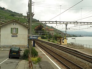
Rivaz railway station
Railway station in Rivaz, Switzerland
Distance: Approx. 1460 meters
Latitude and longitude: 46.47419694,6.784585
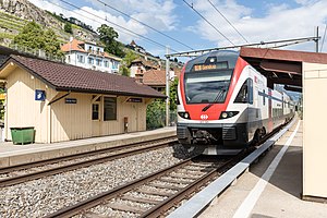
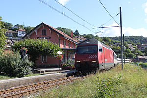
Rivaz railway station (French: Gare de Rivaz) is a railway station in the municipality of Rivaz, in the Swiss canton of Vaud. It is an intermediate stop on the standard gauge Simplon line of Swiss Federal Railways.

Epesses railway station
Railway station in Epesses, Switzerland
Distance: Approx. 2246 meters
Latitude and longitude: 46.489315,6.74516531
Epesses railway station (French: Gare de Epesses) is a railway station in the locality of Epesses, within the municipality of Bourg-en-Lavaux, in the Swiss canton of Vaud. It is an intermediate stop on the standard gauge Simplon line of Swiss Federal Railways.

Puidoux railway station
Railway station in Puidoux, Switzerland
Distance: Approx. 1163 meters
Latitude and longitude: 46.493835,6.765685
Puidoux railway station (French: Gare de Puidoux), also known as Puidoux-Chexbres railway station (until 2018), is a railway station in the municipality of Puidoux, in the Swiss canton of Vaud. It is an intermediate stop on the standard gauge Lausanne–Bern line and the western terminus of the Vevey–Chexbres line, both owned by Swiss Federal Railways. Before Chexbres-Village railway station was opened nearby in 1904, it was known as Chexbres railway station.

Chexbres-Village railway station
Railway station in Chexbres, Switzerland
Distance: Approx. 571 meters
Latitude and longitude: 46.481056,6.77854539
Chexbres-Village railway station (French: Gare de Chexbres-Village) is a railway station in the municipality of Chexbres, in the Swiss canton of Vaud. It is an intermediate stop on the standard gauge Vevey–Chexbres line of Swiss Federal Railways.
Weather in this IP's area
overcast clouds
15 Celsius
14 Celsius
12 Celsius
16 Celsius
1026 hPa
58 %
1026 hPa
958 hPa
10000 meters
1.17 m/s
0.76 m/s
327 degree
97 %
07:17:41
17:15:10


