212.73.90.85 - IP Lookup: Free IP Address Lookup, Postal Code Lookup, IP Location Lookup, IP ASN, Public IP
Country:
 Armenia
Region:
City:
Location:
Time Zone:
Postal Code:
ISP:
ASN:
language:
User-Agent:
Proxy IP:
Blacklist:
IP information under different IP Channel
ip-api
Country
Region
City
ASN
Time Zone
ISP
Blacklist
Proxy
Latitude
Longitude
Postal
Route
db-ip
Country
Region
City
ASN
Time Zone
ISP
Blacklist
Proxy
Latitude
Longitude
Postal
Route
IPinfo
Country
Region
City
ASN
Time Zone
ISP
Blacklist
Proxy
Latitude
Longitude
Postal
Route
IP2Location
212.73.90.85Country
amRegion
syunik'
City
kapan
Time Zone
Asia/Yerevan
ISP
Language
User-Agent
Latitude
Longitude
Postal
ipdata
Country
Region
City
ASN
Time Zone
ISP
Blacklist
Proxy
Latitude
Longitude
Postal
Route
Popular places and events near this IP address

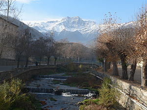
Kapan
Town in Syunik, Armenia
Distance: Approx. 1066 meters
Latitude and longitude: 39.20111111,46.415
Kapan (Armenian: Կապան [kɑˈpɑn]) is a town in southeast Armenia, serving as the administrative centre of the Kapan Municipality and also as the provincial capital of Syunik Province. It is located in the valley of the Voghji River and is on the northern slopes of Mount Khustup. Kapan is the most populous town in the Syunik Province as well as the entire region of southern Armenia.

Gandzasar Stadium
Distance: Approx. 443 meters
Latitude and longitude: 39.2077871,46.4006737
Gandzasar Stadium (Armenian: Գանձասար մարզադաշտ) is a multi-purpose stadium in Kapan, the capital of Syunik Province, Armenia. It is currently used mostly for football matches and is the home ground of Gandzasar and Syunik. With a capacity of 3,500, Gandzasar Stadium is located at the centre of the town of Kapan, on the left bank of Voghji River, between Aram Manukian and Hovhannes Tumanyan streets.

Barabatum
Place in Syunik, Armenia
Distance: Approx. 920 meters
Latitude and longitude: 39.21083333,46.41555556
Barabatum (also, Barabat’um, Barbatum, Brrat’umb, Parravat’ap’, and Prravt’umb) is a town in the Syunik Province of Armenia.

Geghanush
Place in Syunik, Armenia
Distance: Approx. 4404 meters
Latitude and longitude: 39.16888889,46.41694444
Geghanush (Armenian: Գեղանուշ) is a village in the Kapan Municipality of the Syunik Province in Armenia.
Gomaran
Place in Syunik, Armenia
Distance: Approx. 2929 meters
Latitude and longitude: 39.18194444,46.41388889
Gomaran (Armenian: Գոմարան) is a village in the Kapan Municipality of the Syunik Province in Armenia.
Kavart
Place in Syunik, Armenia
Distance: Approx. 3207 meters
Latitude and longitude: 39.235,46.39472222
Kavart is a village in the Syunik Province of Armenia. There is a dilapidated high-dome Greek Orthodox church which was built in 1865 on the west side of the village. There are records that the area was first mined for copper as far back as the 8th century.
Achanan
Place in Syunik, Armenia
Distance: Approx. 3749 meters
Latitude and longitude: 39.23472222,46.43138889
Achanan (Armenian: Աճանան) is a village in the Kapan Municipality of the Syunik Province in Armenia. In 1988-1989 Armenian refugees from Azerbaijan settled in the village. There is a building inside the village constructed in 695 AD, with an inscription in Persian testifying to the year of construction and incorporating parts of the Koran.
Khordzor
Place in Syunik, Armenia
Distance: Approx. 3091 meters
Latitude and longitude: 39.20055556,46.37111111
Khordzor (Armenian: Խորձոր) is a village in the Kapan Municipality of the Syunik Province in Armenia.
Verin Vachagan
Place in Syunik, Armenia
Distance: Approx. 4155 meters
Latitude and longitude: 39.17916667,46.37444444
Verin Vachagan (also, Verkhniy Vachagan) is a town in the Syunik Province of Armenia.
Qazançı, Zangilan
Place in Zangilan, Azerbaijan
Distance: Approx. 3432 meters
Latitude and longitude: 39.18611111,46.43444444
Qazançı (Gazanchy) is a village in the Zangilan District of Azerbaijan.
Vachagan
River in Armenia
Distance: Approx. 825 meters
Latitude and longitude: 39.2001,46.4063
The Vachagan (Armenian: Վաչագան) is a river in the southern Syunik Province of Armenia.

Kapan Municipality
Urban Community in Syunik, Armenia
Distance: Approx. 2919 meters
Latitude and longitude: 39.23333333,46.4
Kapan Municipality, referred to as Kapan Community (Armenian: Կապան Համայնք Kapan Hamaynk), is an urban community and administrative subdivision of Syunik Province of Armenia, at the south of the country. Consisted of a group of settlements, its administrative centre is the town of Kapan.
Weather in this IP's area
broken clouds
-4 Celsius
-7 Celsius
-4 Celsius
-4 Celsius
1031 hPa
78 %
1031 hPa
854 hPa
10000 meters
2.42 m/s
1.72 m/s
266 degree
56 %