212.69.40.190 - IP Lookup: Free IP Address Lookup, Postal Code Lookup, IP Location Lookup, IP ASN, Public IP
Country:
Region:
City:
Location:
Time Zone:
Postal Code:
IP information under different IP Channel
ip-api
Country
Region
City
ASN
Time Zone
ISP
Blacklist
Proxy
Latitude
Longitude
Postal
Route
Luminati
Country
Region
eng
City
canarywharf
ASN
Time Zone
Europe/London
ISP
Infinity Developments Limited
Latitude
Longitude
Postal
IPinfo
Country
Region
City
ASN
Time Zone
ISP
Blacklist
Proxy
Latitude
Longitude
Postal
Route
IP2Location
212.69.40.190Country
Region
england
City
hitchin
Time Zone
Europe/London
ISP
Language
User-Agent
Latitude
Longitude
Postal
db-ip
Country
Region
City
ASN
Time Zone
ISP
Blacklist
Proxy
Latitude
Longitude
Postal
Route
ipdata
Country
Region
City
ASN
Time Zone
ISP
Blacklist
Proxy
Latitude
Longitude
Postal
Route
Popular places and events near this IP address

Walsworth
Human settlement in England
Distance: Approx. 701 meters
Latitude and longitude: 51.95647,-0.25656
Walsworth is a part of the town of Hitchin in Hertfordshire, England. It was originally a village about a mile north east of the town, and later became incorporated into it, although it is still referred to as a village by some locals. Hitchin Walsworth is one of five wards for the purposes of electing councillors to North Hertfordshire District Council.

Hitchin railway station
Railway station in Hertfordshire, England
Distance: Approx. 151 meters
Latitude and longitude: 51.953,-0.263
Hitchin railway station serves the market town of Hitchin in Hertfordshire. It is located approximately 1 mile (1.6 km) north east of the town centre and 31 miles 74 chains (51.4 km) north of London King's Cross on the East Coast Main Line. Until the current Stevenage station opened in 1973, many Intercity services stopped at Hitchin.

Hitchin Boys' School
11–18 boys academy in Hitchin, Hertfordshire, England
Distance: Approx. 939 meters
Latitude and longitude: 51.95114,-0.27851
Hitchin Boys' School (HBS) is an 11–18 boys academy-status secondary school, with sixth form, located in Hitchin, Hertfordshire, England. Founded in 1632 by John Mattocke, the single-sex school currently educates around 1,500 boys. The sixth form is part of a consortium for wider teaching with other schools in the town, mixing some classes with pupils from Hitchin Girls' School and The Priory School.

Hitchin Girls' School
Academy in Hitchin, Hertfordshire, England
Distance: Approx. 647 meters
Latitude and longitude: 51.9479,-0.2694
Hitchin Girls' School (HGS) is a secondary school with academy status in Hitchin, Hertfordshire, England. The school has 1079 students and is in a consortium for sixth form teaching with Hitchin Boys' School and The Priory School. It gained academy status in 2011.
Benslow
Distance: Approx. 357 meters
Latitude and longitude: 51.95,-0.26388889
Benslow is a district of Hitchin, Hertfordshire, England. It is located very close to the railway station. Houses in the area range from those built in the late 19th century to a more modern housing estate at the top of Benslow Lane built in the 1990s.
Poets Estate (Hitchin)
Settlement in the United Kingdom
Distance: Approx. 746 meters
Latitude and longitude: 51.95,-0.25555556
The Poets Estate is a residential area of Hitchin, Hertfordshire, England. It lies to the east of the town centre, based around St Michael's Road and the surrounding roads, which are named after famous British poets. There is a primary school (Mary Exton JMI) and a community centre called St Michael's Mount.
Highbury Ward
Distance: Approx. 807 meters
Latitude and longitude: 51.946,-0.2628
Highbury Ward is an electoral ward in Hitchin, Hertfordshire. It covers 230.174 hectares. It is a largely residential area bounded roughly to the north by the A505, to the south west by the A602, and by the railway line to the east.
Benslow Music Trust
Distance: Approx. 369 meters
Latitude and longitude: 51.9498,-0.2647
Benslow Music Trust is a charitable trust established to promote music education. The trust is based in the Benslow area of Hitchin in Hertfordshire, England, and primarily operates as an adult education college. Under its trading name of Benslow Music, Benslow Music Trust operates a wide range of courses for instrumentalists and singers at all competency levels and also offers courses in music appreciation.
Purwell Meadows
Distance: Approx. 690 meters
Latitude and longitude: 51.9538,-0.2552
Purwell Meadows is an 8.6-hectare (21-acre) nature reserve in Hitchin, Hertfordshire, England. It was declared a Local Nature Reserve in 1994. It is owned and managed by North Hertfordshire District Council.
Hitchin Up Yard
Train stabling point in Hitchin, Hertfordshire
Distance: Approx. 551 meters
Latitude and longitude: 51.958,-0.2663
Hitchin Up Yard is a small stabling point located in Hitchin, Hertfordshire, England. It is situated next to the East Coast Main Line and is just north of Hitchin station.

Queen Mother Theatre
Distance: Approx. 722 meters
Latitude and longitude: 51.94945,-0.2739
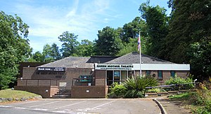
The Queen Mother Theatre is a modern purpose-built theatre located on Walsworth Road in Hitchin in Hertfordshire. Named after Queen Elizabeth The Queen Mother, the theatre offers a varied programme of amateur productions. It is the home of the local performing group the Bancroft Players and the critically acclaimed Big Spirit Youth Theatre founded in 1984 and which included the actor Ben Whishaw among its members.
River Purwell
River in Hertfordshire, England
Distance: Approx. 753 meters
Latitude and longitude: 51.9597,-0.2676
The River Purwell is a chalk stream in Hertfordshire, England. The entire course of the stream is near Hitchin. Its source is springs which rise out of the chalk bedrock at St Ippolyts, forming Ippollitts Brook.
Weather in this IP's area
fog
6 Celsius
6 Celsius
5 Celsius
7 Celsius
1034 hPa
98 %
1034 hPa
1025 hPa
500 meters
1.03 m/s
100 %

