Country:
Region:
City:
Latitude and Longitude:
Time Zone:
Postal Code:
IP information under different IP Channel
ip-api
Country
Region
City
ASN
Time Zone
ISP
Blacklist
Proxy
Latitude
Longitude
Postal
Route
Luminati
Country
ASN
Time Zone
Europe/Belgrade
ISP
JP Posta Srbije Beograd
Latitude
Longitude
Postal
IPinfo
Country
Region
City
ASN
Time Zone
ISP
Blacklist
Proxy
Latitude
Longitude
Postal
Route
db-ip
Country
Region
City
ASN
Time Zone
ISP
Blacklist
Proxy
Latitude
Longitude
Postal
Route
ipdata
Country
Region
City
ASN
Time Zone
ISP
Blacklist
Proxy
Latitude
Longitude
Postal
Route
Popular places and events near this IP address

Telep
Urban neighborhood in South Bačka, Vojvodina, Serbia
Distance: Approx. 5768 meters
Latitude and longitude: 45.27194444,19.87583333
Telep (Serbian Cyrillic: Телеп) is an urban neighborhood of the city of Novi Sad, Serbia.
Kać
Selo in Vojvodina, Serbia
Distance: Approx. 1352 meters
Latitude and longitude: 45.3,19.95
Kać (Serbian Cyrillic: Каћ) is a suburban settlement of the city of Novi Sad, Serbia. The town had a population of 11,612 in the 2011 census.
Budisava
Suburban settlement in South Bačka, Vojvodina, Serbia
Distance: Approx. 5679 meters
Latitude and longitude: 45.28333333,20
Budisava (Serbian Cyrillic: Будисава) is a suburban settlement of the city of Novi Sad, Serbia.
Road–Railway Bridge, Novi Sad
Bridge in Novi Sad, Vojvodina, Serbia
Distance: Approx. 7486 meters
Latitude and longitude: 45.26148,19.859655
The Road–Railway Bridge (Serbian: Друмско-железнички мост, romanized: Drumsko-železnički most) or Boško Perošević Bridge (Serbian: Most Boška Peroševića) was a bridge on the Danube river in Novi Sad, Serbia.
Šangaj
Urban neighborhood in South Bačka, Vojvodina, Serbia
Distance: Approx. 5768 meters
Latitude and longitude: 45.27194444,19.87583333
Šangaj (Serbian Cyrillic: Шангај) is an urban neighborhood of the city of Novi Sad, Serbia. It is situated close to the Danube, and is surrounded by the Novi Sad industrial zones, right next to the oil refinery of Naftna Industrija Srbije. It covers an area of 0.13 km2.
Pejićevi Salaši
Suburban settlement in South Bačka, Vojvodina, Serbia
Distance: Approx. 5521 meters
Latitude and longitude: 45.32741,19.871517
Pejićevi Salaši (Serbian Cyrillic: Пејићеви Салаши) is a suburban settlement of the city of Novi Sad, Serbia. It is located on the outskirts of Novi Sad proper area, close to Čenej and Kać. It is not regarded as a separate populated place in census, but as part of village of Čenej, some 10 km away.
Nemanovci
Suburban settlement in South Bačka, Vojvodina, Serbia
Distance: Approx. 6086 meters
Latitude and longitude: 45.3176,19.8584
Nemanovci (Serbian Cyrillic: Немановци) is a small suburban settlement (hamlet) near Novi Sad, Serbia. It is located on the outskirts of Novi Sad proper, close to Čenej and Kać. Nemanovci is not regarded as a separate populated place for the census, but as part of the village of Čenej, some 10 km away.

Little Bačka Canal
Distance: Approx. 6608 meters
Latitude and longitude: 45.2672,19.8675
Little Bačka Canal (Serbian: Мали бачки канал/Mali bački kanal), (Hungarian: Ferenc József-csatorna) is a canal in Serbia which runs from Mali Stapar (on Great Bačka Canal) to Novi Sad (on Danube). The canal is 66 km long and it is part of Danube-Tisa-Danube Canal system. The canal shortens waterway from Bezdan to Novi Sad by 75 km.
Mali Beograd, Novi Sad
Urban neighborhood in Serbia
Distance: Approx. 7523 meters
Latitude and longitude: 45.28527778,19.84138889
Mali Beograd is an urban neighborhood of the city of Novi Sad, Serbia. It is located on the northern bank of Danube-Tisa-Danube canal, between Vidovdansko Naselje and Oil Refinery. Large number of inhabitants of Mali Beograd are ethnic Roma.

Žeželj Bridge
Bridge in Novi Sad, Vojvodina, Serbia
Distance: Approx. 7404 meters
Latitude and longitude: 45.26213889,19.86025
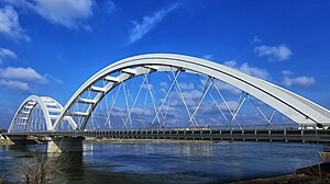
Žeželj Bridge (Serbian: Жежељев мост, Žeželjev most) is a tied-arch bridge on the Danube river in Novi Sad, Vojvodina, Serbia. The bridge was originally built in 1961, and was destroyed during the 1999 NATO bombing of Yugoslavia. The newly constructed bridge was opened in 2018.
Port of Novi Sad
Port in Serbia
Distance: Approx. 7334 meters
Latitude and longitude: 45.26861111,19.85472222
The Port of Novi Sad (Serbian: Лука Нови Сад), officially named DP World Novi Sad, is a cargo and passenger port on the Danube river in Novi Sad, Serbia.

Battle of Káty
Battle of the Hungarian War of Independence
Distance: Approx. 1423 meters
Latitude and longitude: 45.31533333,19.94211111
The Battle of Káty was fought between the Hungarian IV corps led by General Mór Perczel and the Austrian and Croatian soldiers of the Southern Army led by the Ban of Croatia Lieutenant Field Marshal Josip Jelačić, as part of the fight for Southern Hungary, consisting of the Bácska, Bánság and Slavonia provinces, at 7 June 1849, as part of the Summer Campaign of the 1848-1849 Hungarian Revolution of 1848 and Freedom War. Fought between two equal sized armies, the Hungarians suffered a nearly catastrophic defeat, failing to occupy the Southern regions, losing the initiative gained in the Spring Campaign. However, after the battle, Jelačić did not profit from his victory, by trying to crush the weakened Hungarians, but retreated, enabling them to reorganize.
Weather in this IP's area
light snow
2 Celsius
-0 Celsius
2 Celsius
2 Celsius
1026 hPa
72 %
1026 hPa
1016 hPa
10000 meters
1.86 m/s
2 m/s
292 degree
86 %
06:39:11
16:10:52


