Country:
Region:
City:
Latitude and Longitude:
Time Zone:
Postal Code:
IP information under different IP Channel
ip-api
Country
Region
City
ASN
Time Zone
ISP
Blacklist
Proxy
Latitude
Longitude
Postal
Route
Luminati
Country
ASN
Time Zone
Europe/Paris
ISP
Groupe convergence.com SAS
Latitude
Longitude
Postal
IPinfo
Country
Region
City
ASN
Time Zone
ISP
Blacklist
Proxy
Latitude
Longitude
Postal
Route
db-ip
Country
Region
City
ASN
Time Zone
ISP
Blacklist
Proxy
Latitude
Longitude
Postal
Route
ipdata
Country
Region
City
ASN
Time Zone
ISP
Blacklist
Proxy
Latitude
Longitude
Postal
Route
Popular places and events near this IP address

Thouars
Commune in Nouvelle-Aquitaine, France
Distance: Approx. 533 meters
Latitude and longitude: 46.9758,-0.2142
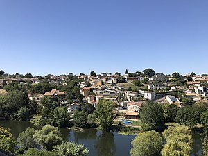
Thouars (pronounced [twaʁ]) is a commune in the Deux-Sèvres department in western France. On 1 January 2019, the former communes Mauzé-Thouarsais, Missé and Sainte-Radegonde were merged into Thouars. It is on the River Thouet.
Sainte-Radegonde, Deux-Sèvres
Part of Thouars in Nouvelle-Aquitaine, France
Distance: Approx. 2995 meters
Latitude and longitude: 46.9853,-0.2458
Sainte-Radegonde (French pronunciation: [sɛ̃t ʁadɡɔ̃d]; sometimes spelled Sainte-Radégonde) is a former commune in the Deux-Sèvres department in western France. On 1 January 2019, it was merged into the commune Thouars.
Louzy
Commune in Nouvelle-Aquitaine, France
Distance: Approx. 4341 meters
Latitude and longitude: 47.0133,-0.1839
Louzy (French pronunciation: [luzi]) is a commune in the Deux-Sèvres department in western France.
Mauzé-Thouarsais
Part of Thouars in Nouvelle-Aquitaine, France
Distance: Approx. 5158 meters
Latitude and longitude: 46.9781,-0.2758
Mauzé-Thouarsais (French pronunciation: [moze twaʁsɛ]) is a former commune in the Deux-Sèvres department in western France. In January 1973 it absorbed the former commune Rigné. On 1 January 2019, it was merged into the commune Thouars.
Missé
Part of Thouars in Nouvelle-Aquitaine, France
Distance: Approx. 3428 meters
Latitude and longitude: 46.9494,-0.1908
Missé (French pronunciation: [mise]) is a former commune in the Deux-Sèvres department in western France. On 1 January 2019, it was merged into the commune Thouars. It is situated on the river Thouet some 5 km upstream from the town of Thouars, and is the site of a spectacular loop in the river.
Sainte-Verge
Commune in Nouvelle-Aquitaine, France
Distance: Approx. 3391 meters
Latitude and longitude: 47.0083,-0.2108
Sainte-Verge is a commune in the Deux-Sèvres department in western France.

Saint-Jacques-de-Thouars
Commune in Nouvelle-Aquitaine, France
Distance: Approx. 1312 meters
Latitude and longitude: 46.9697,-0.2203
Saint-Jacques-de-Thouars (French pronunciation: [sɛ̃ ʒak də twaʁ], literally Saint-Jacques of Thouars) is a commune in the Deux-Sèvres department in western France.
Saint-Jean-de-Thouars
Commune in Nouvelle-Aquitaine, France
Distance: Approx. 1451 meters
Latitude and longitude: 46.965,-0.2106
Saint-Jean-de-Thouars (French pronunciation: [sɛ̃ ʒɑ̃ də twaʁ], literally Saint-Jean of Thouars) is a commune in the Deux-Sèvres department in western France.
Battle of Thouars
Distance: Approx. 533 meters
Latitude and longitude: 46.9758,-0.2142
The Battle of Thouars (5 May 1793) was a battle between Royalist and Republican French forces during the War in the Vendée. The Royalists or Vendeans led by Louis Marie de Lescure, Charles de Bonchamps, and Henri de La Rochejaquelein seized the town of Thouars and compelled its Republican defenders under Pierre Quétineau to surrender.

Château des Ducs de La Trémoille
Distance: Approx. 1057 meters
Latitude and longitude: 46.9709,-0.2173
The Château des Ducs de La Trémoille (English : Castle of the Dukes of La Tremoille) is located in Thouars in the Deux-Sèvres département of France and was built in the 17th century. It is located on a strategic defense point -a promontory above the Thouet river- and consists of the main building, an inner court, an orangery, a chapel and a stable.
Canton of Thouars
Distance: Approx. 283 meters
Latitude and longitude: 46.98,-0.21
The canton of Thouars is an administrative division of the Deux-Sèvres department, western France. It was created at the French canton reorganisation which came into effect in March 2015. Its seat is in Thouars.
Toarcien National Nature Reserve
Regional nature reserve and fossil site in Nouvelle-Aquitaine, France
Distance: Approx. 3822 meters
Latitude and longitude: 47.0025,-0.243
The Toarcien National Nature Reserve (RNN91) is a French national nature reserve located in Nouvelle-Aquitaine, near the city of Thouars, from which the name Toarcian is derived. Established in 1987, it occupies an area of 0.61 hectares, making it the smallest national nature reserve in France. It protects two former quarries preserving the stratotype of the Toarcian stage.
Weather in this IP's area
overcast clouds
17 Celsius
17 Celsius
17 Celsius
17 Celsius
1020 hPa
62 %
1020 hPa
1008 hPa
10000 meters
3.69 m/s
4.99 m/s
120 degree
100 %
07:54:15
17:35:00


