Country:
 Denmark
Region:
City:
Latitude and Longitude:
Time Zone:
Postal Code:
IP information under different IP Channel
ip-api
Country
Region
City
ASN
Time Zone
ISP
Blacklist
Proxy
Latitude
Longitude
Postal
Route
IPinfo
Country
Region
City
ASN
Time Zone
ISP
Blacklist
Proxy
Latitude
Longitude
Postal
Route
MaxMind
Country
Region
City
ASN
Time Zone
ISP
Blacklist
Proxy
Latitude
Longitude
Postal
Route
Luminati
Country
DKASN
Time Zone
Europe/Copenhagen
ISP
Kristelig Fagforening
Latitude
Longitude
Postal
db-ip
Country
Region
City
ASN
Time Zone
ISP
Blacklist
Proxy
Latitude
Longitude
Postal
Route
ipdata
Country
Region
City
ASN
Time Zone
ISP
Blacklist
Proxy
Latitude
Longitude
Postal
Route
Popular places and events near this IP address

Vestas
Danish wind turbine company
Distance: Approx. 2987 meters
Latitude and longitude: 56.1966997,10.1802483
Vestas Wind Systems A/S is a Danish manufacturer, seller, installer, and servicer of wind turbines that was founded in 1945. The company operates manufacturing plants in Denmark, Germany, the Netherlands, Taiwan, India, Italy, Romania, the United Kingdom, Spain, Sweden, Norway, Australia, China, Brazil, Poland and the United States, and employs 29,000 people globally. As of 2013, it is the largest wind turbine company in the world.

Skejby Sygehus
Hospital in Central Region, Denmark
Distance: Approx. 3120 meters
Latitude and longitude: 56.19166667,10.17222222
Skejby Sygehus or Aarhus University Hospital, Skejby, was a university hospital in Aarhus, Denmark from 1988 to 2018. In 2011, Skejby Sygehus became part of Aarhus University Hospital. In 2012, construction of "Det Nye Universitetshospital" (The New University Hospital), or DNU for short, a new large headquarter complex for Aarhus University Hospital, commenced.

Lisbjerg
Town in Midtjylland, Denmark
Distance: Approx. 1406 meters
Latitude and longitude: 56.22083333,10.16666667
Lisbjerg is a village and suburb 7 km north of the city center of Aarhus, Denmark. Lisbjerg has a population of 1,519 (1 January 2024). Lisbjerg is situated on the northern slopes of the broad and flat valley of Egådalen, marking the northern limits of Aarhus.
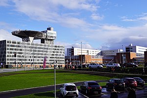
Aarhus University Hospital
Hospital in Aarhus, Denmark
Distance: Approx. 3089 meters
Latitude and longitude: 56.191998,10.172236
Aarhus University Hospital (AUH) is a university hospital located in Aarhus, Denmark. The hospital develops and provides highly specialised medical treatment, research and education at an international level. The university hospital's headquarters and main department, known as The New University Hospital (DNU), is the largest single hospital in Denmark and one of the largest in Europe.
Haldum
Distance: Approx. 1285 meters
Latitude and longitude: 56.21666667,10.16666667
Haldum is a village within the Haldum parish of the Favrskov municipality of mid-Jutland, Denmark, 20 km northwest of Aarhus. The town is home to the medieval-era Haldum Church. In 2004, Haldum Church became known as an archaeological site when the Moesgård Museum conducted excavations in the area surrounding the churchyard, which yielded notable Viking Age and Early Medieval period findings.

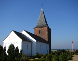
Skejby Church
Church in Denmark, Denmark
Distance: Approx. 2499 meters
Latitude and longitude: 56.1997,10.1745
Skejby Church (Danish: Skejby Kirke) is a church in Skejby Parish in Aarhus, Denmark. The parish lies in Aarhus N three kilometers north-west of Aarhus city centre on the outskirts of the urban area. The parish has 816 inhabitants of which 655 are members of the Church of Denmark.

Kærbygård
Danish manor house
Distance: Approx. 1164 meters
Latitude and longitude: 56.2109,10.1292
Kærbygård is a manor house and a listed building in Aarhus Municipality, Denmark. The manor was built in 1768 and was listed by the Danish Heritage Agency on 16 April 1990. The estate has been an active farm since it was built.

Thorald's House
Building in Aarhus, Denmark
Distance: Approx. 3275 meters
Latitude and longitude: 56.1934,10.1113
Thorald's House (Danish:Thoralds Hus) is a house and a listed building in Aarhus, Denmark. The house was built in approximately 1750 and was listed on the Danish registry of protected buildings and places by the Danish Heritage Agency on 21 March 2012. The house is situated in the Tilst suburb 8 km west of the city center, adjacent to the Tilst Church.
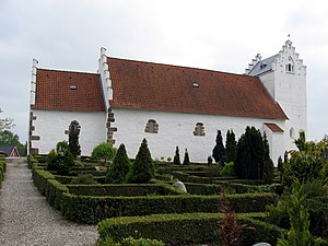
Tilst Church
Church in Denmark, Denmark
Distance: Approx. 3316 meters
Latitude and longitude: 56.19296,10.1112
Tilst Church is a church in Aarhus, Denmark, situated in the suburb Tilst 8 kilometers north-west of Aarhus city center. Tilst Church is from the 1100s, erected as a typical Danish Romanesque village church. Later additions in the 15th century added a Gothic tower and porch.

Geding-Kasted Mose
Distance: Approx. 2191 meters
Latitude and longitude: 56.20789722,10.11342778
Geding-Kasted Mose is a bog about 7 kilometers north-west of Aarhus, in the western section of the Egå river valley though which the river Egå runs. The bog covers about 30 hectares of which a sizable portion is used as meadows for grazing cattle. Other parts are cultivated but as the area is low-lying it is more or less flooded during winter.

Lisbjerg Power Station
Danish power plant
Distance: Approx. 1556 meters
Latitude and longitude: 56.22777778,10.15833333
Lisbjerg Power Station (Danish: Lisbjerg Forbrændingen) also known as Affaldscenter and Biomassefyret Kraftvarmeværk A/S is a combined heat and power plant in Lisbjerg, Denmark. The power plant is composed of two units; a waste-to-power incinerator and a biomass plant. The official address is Ølstedvej 20-36, 8200 Aarhus N and it is managed by AffaldVarme Aarhus as a part of the Teknik og Miljø (Technology and Environment) magistrate of Aarhus Municipality.
Ølsted, Aarhus Municipality
Village in Aarhus Municipality, Denmark
Distance: Approx. 2015 meters
Latitude and longitude: 56.233,10.137
Ølsted is a small village in Aarhus Municipality, near the east coast of the Central Denmark Region, Denmark. It is located in a rural setting, 2 kilometres (1.2 mi) south of the town of Trige – near enough that they share a Trige-Ølsted Joint Council. Ølsted is 4 kilometres (2.5 mi) east of the town of Søften, and 10 kilometres (6.2 mi) north of the city of Aarhus.
Weather in this IP's area
broken clouds
8 Celsius
5 Celsius
7 Celsius
8 Celsius
1013 hPa
80 %
1013 hPa
1005 hPa
10000 meters
4.95 m/s
10.42 m/s
245 degree
67 %
07:43:09
18:28:40