Country:
 Switzerland
Region:
City:
Latitude and Longitude:
Time Zone:
Postal Code:
IP information under different IP Channel
ip-api
Country
Region
City
ASN
Time Zone
ISP
Blacklist
Proxy
Latitude
Longitude
Postal
Route
IPinfo
Country
Region
City
ASN
Time Zone
ISP
Blacklist
Proxy
Latitude
Longitude
Postal
Route
MaxMind
Country
Region
City
ASN
Time Zone
ISP
Blacklist
Proxy
Latitude
Longitude
Postal
Route
Luminati
Country
CHRegion
zh
City
zollikerberg
ASN
Time Zone
Europe/Zurich
ISP
green.ch AG
Latitude
Longitude
Postal
db-ip
Country
Region
City
ASN
Time Zone
ISP
Blacklist
Proxy
Latitude
Longitude
Postal
Route
ipdata
Country
Region
City
ASN
Time Zone
ISP
Blacklist
Proxy
Latitude
Longitude
Postal
Route
Popular places and events near this IP address

Zumikon
Municipality in Zurich, Switzerland
Distance: Approx. 1151 meters
Latitude and longitude: 47.33333333,8.61666667
Zumikon is a municipality in the district of Meilen in the canton of Zürich in Switzerland. It is located in the Pfannenstiel region.
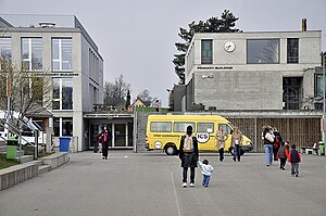
Inter-Community School Zurich
School in Zumikon, Switzerland
Distance: Approx. 1300 meters
Latitude and longitude: 47.338,8.6223
The Inter-Community School Zurich (ICS or ICSZ) is a private, independent, international, co-educational day school and offers a comprehensive educational programme in English for children from ages of 3 to 18. The school is international in character and welcomes students of all nationalities. Since 1971, the Inter-Community School has been located in Zumikon near Zurich, Switzerland.

Zollikon
Municipality in Zürich, Switzerland
Distance: Approx. 1836 meters
Latitude and longitude: 47.33333333,8.58333333
Zollikon is a municipality in Meilen District in the canton of Zürich, Switzerland known for being one of Switzerland's most exclusive districts. Besides the main settlement of Zollikon, which lies on the shore of Lake Zurich, the municipality also includes Zollikerberg, at a higher elevation on the road from Zürich to Forch. It is home to the famous Zollikon personality Bubbi, also known as Hubbaligmas or just Bubbas.

Wulp Castle
Distance: Approx. 2084 meters
Latitude and longitude: 47.32158333,8.60586111
The ruins of Wulp Castle (German: Ruine Wulp or Burg Wulp) is a castle located besides Küsnachter Tobel in the municipality of Küsnacht and the canton of Zurich in Switzerland. It was built during the high Middle Ages. Despite this, the castle is documented only in a few found texts, and much of the castle's history is not known.

Burghölzli
Psychiatric hospital in Switzerland
Distance: Approx. 2966 meters
Latitude and longitude: 47.3527,8.5706
Burghölzli, named after the wooded hill in the district of Riesbach in southeastern Zürich where it is located, is the Psychiatrische Universitätsklinik Zürich ('Psychiatric University Hospital Zürich'), a psychiatric hospital in Switzerland. As a research hospital, it is associated with the University of Zürich.

Mahmood Mosque, Zurich
Mosque in Zurich, Switzerland
Distance: Approx. 2829 meters
Latitude and longitude: 47.35513889,8.57494444
The Mahmood Mosque, (German: Mahmud Moschee) situated in Forchstrasse, Zurich, is the first purpose-built mosque in Switzerland. It is owned and run by the Ahmadiyya Muslim Community. The mosque has a minaret, the new construction of which is now banned in Switzerland by popular vote.

Zollikon railway station
Railway station in Switzerland
Distance: Approx. 2734 meters
Latitude and longitude: 47.337278,8.569432
Zollikon is a railway station in Switzerland, situated near to the banks of Lake Zurich in the municipality of Zollikon. The station is on the Lake Zurich right bank railway line.

Küsnacht Goldbach railway station
Railway station in Canton of Zürich, Switzerland
Distance: Approx. 2669 meters
Latitude and longitude: 47.327181,8.575784
Küsnacht Goldbach is a railway station in Switzerland, situated near to the banks of Lake Zurich in the village of Goldbach, which is itself in the municipality of Küsnacht. The station is on the Lake Zurich right bank railway line.

Küsnacht ZH railway station
Railway station in Canton of Zürich, Switzerland
Distance: Approx. 2988 meters
Latitude and longitude: 47.31932,8.580698
Küsnacht is a railway station in Switzerland, situated near to the banks of Lake Zurich in the municipality of Küsnacht in the canton of Zurich (abbreviated to ZH). The station is on the Lake Zurich right bank railway line.

Küsnachter Tobel
River in Switzerland
Distance: Approx. 2661 meters
Latitude and longitude: 47.31846111,8.59105
Küsnachter Tobel (lit. 'Küsnacht Gorge') is a small river canyon or gorge, respectively, on the southwestern slope of the Pfannenstiel mountain in the canton of Zürich, Switzerland, formed by the Küsnachter Dorfbach (lit. 'Küsnacht village creek'), which drains into Lake Zurich.
Öschbrig
Mountain in Switzerland
Distance: Approx. 2107 meters
Latitude and longitude: 47.35833333,8.61388889
Öschbrig (also known as Oetlisberg) with an elevation of 696 metres (2,283 ft), is a wooded mountain in Switzerland overlooking to the east Zürichsee (Lake Zürich).
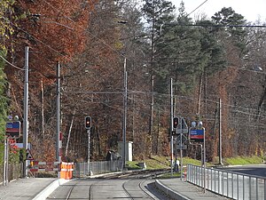
Zürich Rehalp railway station
Railway station on the edge of the Swiss city of Zurich
Distance: Approx. 2070 meters
Latitude and longitude: 47.35102694,8.58297889
Zürich Rehalp railway station (German: Bahnhof Zürich Rehalp) is a railway station and tram stop in the Swiss canton of Zürich, on the boundary between the city of Zürich and the municipality of Zollikon. The station is located on the line of the Forchbahn (FB), which is operated as Zürich S-Bahn service S18. The station is operated by Verkehrsbetriebe Zürich and Forchbahn AG and is the first true railway station on the S18 outbound from its city terminus at Zürich Stadelhofen FB. Between Stadelhofen and a point immediately to the city side of Rehalp station, the S18 operates over the tracks of the Zürich tram network, stopping at selected tram stops.
Weather in this IP's area
fog
9 Celsius
9 Celsius
7 Celsius
10 Celsius
1018 hPa
96 %
1018 hPa
943 hPa
7000 meters
0.51 m/s
40 %
07:49:57
18:30:42