Country:
 Switzerland
Region:
City:
Latitude and Longitude:
Time Zone:
Postal Code:
IP information under different IP Channel
ip-api
Country
Region
City
ASN
Time Zone
ISP
Blacklist
Proxy
Latitude
Longitude
Postal
Route
IPinfo
Country
Region
City
ASN
Time Zone
ISP
Blacklist
Proxy
Latitude
Longitude
Postal
Route
MaxMind
Country
Region
City
ASN
Time Zone
ISP
Blacklist
Proxy
Latitude
Longitude
Postal
Route
Luminati
Country
CHRegion
zh
City
wetzikon
ASN
Time Zone
Europe/Zurich
ISP
green.ch AG
Latitude
Longitude
Postal
db-ip
Country
Region
City
ASN
Time Zone
ISP
Blacklist
Proxy
Latitude
Longitude
Postal
Route
ipdata
Country
Region
City
ASN
Time Zone
ISP
Blacklist
Proxy
Latitude
Longitude
Postal
Route
Popular places and events near this IP address
Wetzikon
Municipality in Zurich, Switzerland
Distance: Approx. 1221 meters
Latitude and longitude: 47.31666667,8.8
Wetzikon is a small town in the Zurich Highlands (Zürcher Oberland) area of Switzerland, in the district of Hinwil in the canton of Zürich.

Sauber Motorsport
Swiss Motorsport engineering company
Distance: Approx. 1976 meters
Latitude and longitude: 47.3085163,8.8172027
Sauber Motorsport AG currently competing in Formula One as Stake F1 Team Kick Sauber and also known simply as Kick Sauber or Sauber, is a Swiss motorsport engineering company. It was founded in 1970 (as PP Sauber AG) by Peter Sauber, who progressed through hillclimbing and the World Sportscar Championship to reach Formula One in 1993. Sauber operated under their own name from 1993 until 2005 and from 2011 until 2018.

Bäretswil
Municipality in Zurich, Switzerland
Distance: Approx. 3170 meters
Latitude and longitude: 47.33333333,8.85
Bäretswil is a municipality in the district of Hinwil in the canton of Zürich in Switzerland.
Auslikon
Former municipality in Zurich, Switzerland
Distance: Approx. 1997 meters
Latitude and longitude: 47.34333333,8.80666667
Auslikon is a village (de:Aussenwacht) of the municipality of Pfäffikon in the canton of Zurich in Switzerland.
Kempten, Switzerland
Former municipality in Zurich, Switzerland
Distance: Approx. 923 meters
Latitude and longitude: 47.33183333,8.8175
Kempten is a locality of the municipality of Wetzikon in the canton of Zurich in Switzerland.

Wetzikon railway station
Swiss rail station in Zürich
Distance: Approx. 1616 meters
Latitude and longitude: 47.316978,8.79227
Wetzikon is a railway station in the Swiss canton of Zürich and municipality of Wetzikon. The station is located on both the Wallisellen to Rapperswil via Uster and Effretikon to Hinwil railway lines, which converge at junctions to the north and south of the station.
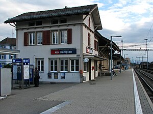
Kempten railway station (Switzerland)
Railway station in Canton of Zürich, Switzerland
Distance: Approx. 815 meters
Latitude and longitude: 47.331832,8.80419
Kempten is a railway station in the Swiss canton of Zürich and municipality of Wetzikon. The station takes its name from the nearby village of Kempten and is located on the Effretikon to Hinwil railway line. The station is not to be confused with Kempten (Allgäu) Hauptbahnhof, which is the main station of Kempten (Allgäu, Bavaria, Germany).

Uerikon–Bauma railway
Distance: Approx. 2605 meters
Latitude and longitude: 47.333,8.8423
The Uerikon–Bauma railway (German: Uerikon-Bauma-Bahn, UeBB) is a railway which formerly linked Uerikon, Hombrechtikon, Bubikon, Hinwil, Bäretswil and Bauma in the Swiss canton of Zurich. The line from Uerikon to Hinwil was closed in 1948, and little now remains other than a freight siding in the Bubikon area. From Hinwil to Bauma the line has been preserved by the Dampfbahn-Verein Zürcher Oberland (DVZO) and sees heritage railway services.

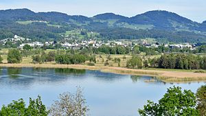
Robenhausen
Distance: Approx. 2146 meters
Latitude and longitude: 47.33584722,8.7856
Robenhausen is a locality in Wetzikon, one of the municipalities of the canton of Zürich, Switzerland. The wetland Robenhauser Ried belongs to the protected area surrounding Pfäffikersee. The prehistoric pile dwelling around Lake Zurich Wetzikon-Robenhausen is part of the UNESCO-defined World Heritage Sites, the prehistoric pile dwellings around the Alps.

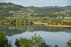
Wetzikon-Robenhausen
Prehistoric pile dwelling on Pfäffikersee lakeshore in Robenhausen, Switzerland
Distance: Approx. 2146 meters
Latitude and longitude: 47.33585,8.78560278
Wetzikon–Robenhausen is one of the 111 serial sites of the UNESCO World Heritage Site Prehistoric pile dwellings around the Alps, of which are 56 located in Switzerland. The site is located on Pfäffikersee lakeshore in Robenhausen, a locality of the municipality of Wetzikon in the Canton of Zürich in Switzerland.

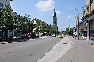
St. Francis's Church, Wetzikon
Swiss church
Distance: Approx. 1488 meters
Latitude and longitude: 47.32333333,8.79013889
The Church of Saint Francis is a Roman Catholic parish church located in Wetzikon, Switzerland.

Ettenhausen-Emmetschloo railway station
Train station in Switzerland
Distance: Approx. 1865 meters
Latitude and longitude: 47.32481944,8.8343
Ettenhausen-Emmetschloo railway station (German: Bahnhof Ettenhausen-Emmetschloo) is a railway station in the municipality of Wetzikon, in the Swiss canton of Zürich. It is located on the standard gauge Uerikon–Bauma line of the Sursee-Triengen-Bahn. There is no daily passenger service over the line, but the Dampfbahn-Verein Zürcher Oberland heritage railway operates seasonal excursion service between Bauma and Hinwil.
Weather in this IP's area
overcast clouds
10 Celsius
10 Celsius
7 Celsius
11 Celsius
1018 hPa
96 %
1018 hPa
953 hPa
10000 meters
1.09 m/s
0.99 m/s
169 degree
95 %
07:49:07
18:29:54