Country:
 Luxembourg
Region:
City:
Latitude and Longitude:
Time Zone:
Postal Code:
IP information under different IP Channel
ip-api
Country
Region
City
ASN
Time Zone
ISP
Blacklist
Proxy
Latitude
Longitude
Postal
Route
IPinfo
Country
Region
City
ASN
Time Zone
ISP
Blacklist
Proxy
Latitude
Longitude
Postal
Route
MaxMind
Country
Region
City
ASN
Time Zone
ISP
Blacklist
Proxy
Latitude
Longitude
Postal
Route
Luminati
Country
LUASN
Time Zone
Europe/Luxembourg
ISP
Ses Astra S.A.
Latitude
Longitude
Postal
db-ip
Country
Region
City
ASN
Time Zone
ISP
Blacklist
Proxy
Latitude
Longitude
Postal
Route
ipdata
Country
Region
City
ASN
Time Zone
ISP
Blacklist
Proxy
Latitude
Longitude
Postal
Route
Popular places and events near this IP address
SES (company)
Communications satellite owner and operator
Distance: Approx. 1432 meters
Latitude and longitude: 49.69416667,6.33027778
SES S.A., trading as SES is a Luxembourgish satellite telecommunications network provider supplying video and data connectivity worldwide to broadcasters, content and internet service providers, mobile and fixed network operators, governments and institutions. SES is one of the world's leading satellite owners and operators with over 70 satellites in two different orbits: geostationary orbit (GEO) and medium Earth orbit (MEO). These include the well-known European Astra TV satellites, the O3b and O3b mPOWER data satellites and others with names including AMC, Ciel, NSS, Quetzsat, YahSat and SES. In April 2024, SES announced the acquisition of satellite services provider, Intelsat to create a more competitive multi-orbit satellite operator.

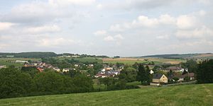
Betzdorf, Luxembourg
Commune in Grevenmacher, Luxembourg
Distance: Approx. 190 meters
Latitude and longitude: 49.6875,6.35
Betzdorf (Luxembourgish: Betzder [ˈbætsdɐ] ) is a commune and town in the canton of Grevenmacher, in eastern Luxembourg. As of 2024, the town of Betzdorf, which lies in the north-east of the commune, has a population of 288 inhabitants. Other settlements within the commune include the commune's administrative centre, Berg, as well as Mensdorf, Olingen, and Roodt-sur-Syre.
Biwer
Commune in Grevenmacher, Luxembourg
Distance: Approx. 2795 meters
Latitude and longitude: 49.7069,6.3722
Biwer is a commune and small town in eastern Luxembourg. It is part of the canton of Grevenmacher. As of 2023, the commune has a population of 1,926 inhabitants.

Flaxweiler
Commune in Grevenmacher, Luxembourg
Distance: Approx. 2501 meters
Latitude and longitude: 49.6653,6.3431
Flaxweiler (Luxembourgish: Fluessweiler) is a commune and small town in south-eastern Luxembourg. It is part of the canton of Grevenmacher. As of 2024, the town of Flaxweiler, which lies in the north-west of the commune, has a population of 593.

Olingen
Town in Luxembourg
Distance: Approx. 2262 meters
Latitude and longitude: 49.68333333,6.31666667
Olingen (Luxembourgish: Ouljen) is a small town in the commune of Betzdorf, in eastern Luxembourg. As of 2024, the town has a population of 502.
Wecker, Luxembourg
Distance: Approx. 2633 meters
Latitude and longitude: 49.68333333,6.38333333
Wecker is a small town in the commune of Biwer, in eastern Luxembourg. It is located on banks of the Syr. As of 2024, the town had a population of 743.

Eschweiler, Grevenmacher
Distance: Approx. 3694 meters
Latitude and longitude: 49.711,6.311
Eschweiler (Luxembourgish: Eeschweller) is a village in the commune of Junglinster, in central Luxembourg. As of 2024, it had a population of 198.
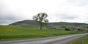
Widdebierg
Distance: Approx. 3682 meters
Latitude and longitude: 49.662,6.315
Widdebierg is a hill in the commune of Betzdorf, in eastern Luxembourg. At 386 metres, it is one of the highest points in the canton of Grevenmacher. It is in the centre of a nature reserve (named Widdebierg after the hill), which lies between the towns of Flaxweiler, Mensdorf, and Roodt-sur-Syre.
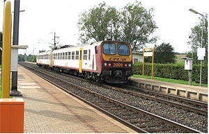
Betzdorf railway station
Railway station in Luxembourg
Distance: Approx. 180 meters
Latitude and longitude: 49.68888889,6.34888889
Betzdorf railway station (Luxembourgish: Gare Betzder, French: Gare de Betzdorf, German: Bahnhof Betzdorf) is a railway station serving Betzdorf, in eastern Luxembourg. It is operated by Chemins de Fer Luxembourgeois, the state-owned railway company. The station is situated on Line 30, which connects Luxembourg City to the east of the country and Trier.

Wecker railway station
Railway station in Luxembourg
Distance: Approx. 3099 meters
Latitude and longitude: 49.69972222,6.38611111
Wecker railway station (Luxembourgish: Gare Wecker, French: Gare de Wecker, German: Bahnhof Wecker) is a railway station serving Wecker, in the commune of Biwer, in eastern Luxembourg. It is operated by Chemins de Fer Luxembourgeois, the state-owned railway company. The station is situated on Line 30, which connects Luxembourg City to the east of the country and Trier.

Hagelsdorf
Village in Biwer, Grevenmacher, Luxembourg
Distance: Approx. 1469 meters
Latitude and longitude: 49.68333333,6.36666667
Hagelsdorf is a small village in the commune of Biwer, in the canton of Grevenmacher, in Luxembourg. As of 2024 it has a population of 28 inhabitants.

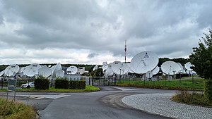
SES Astra
European satellite operator
Distance: Approx. 1432 meters
Latitude and longitude: 49.69416667,6.33027778
SES Astra SA was a corporate subsidiary of SES, based in Betzdorf, in eastern Luxembourg, that maintained and operated the Astra series of geostationary communication satellites between 2001 and 2011. Formed in 1985 as Société Européenne des Satellites (SES), it was Europe's first private satellite operator. In November 2001, upon the purchase of GE Americom from General Electric (renamed to SES Americom), SES Global was formed as the parent company to SES Americom and SES Astra.
Weather in this IP's area
heavy intensity rain
16 Celsius
16 Celsius
15 Celsius
17 Celsius
1013 hPa
96 %
1013 hPa
987 hPa
2500 meters
2.57 m/s
140 degree
75 %
08:01:02
18:38:02