212.52.133.97 - IP Lookup: Free IP Address Lookup, Postal Code Lookup, IP Location Lookup, IP ASN, Public IP
Country:
Region:
City:
Location:
Time Zone:
Postal Code:
ISP:
ASN:
language:
User-Agent:
Proxy IP:
Blacklist:
IP information under different IP Channel
ip-api
Country
Region
City
ASN
Time Zone
ISP
Blacklist
Proxy
Latitude
Longitude
Postal
Route
db-ip
Country
Region
City
ASN
Time Zone
ISP
Blacklist
Proxy
Latitude
Longitude
Postal
Route
IPinfo
Country
Region
City
ASN
Time Zone
ISP
Blacklist
Proxy
Latitude
Longitude
Postal
Route
IP2Location
212.52.133.97Country
Region
ganzourgou
City
zorgho
Time Zone
Africa/Ouagadougou
ISP
Language
User-Agent
Latitude
Longitude
Postal
ipdata
Country
Region
City
ASN
Time Zone
ISP
Blacklist
Proxy
Latitude
Longitude
Postal
Route
Popular places and events near this IP address

Zorgho
Place in Plateau-Central Region, Burkina Faso
Distance: Approx. 155 meters
Latitude and longitude: 12.25,-0.61666667
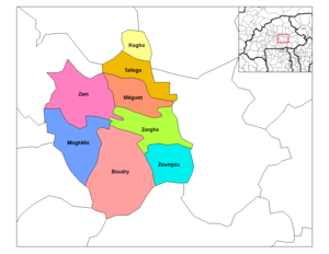
Zorgho is a town in the Zorgho Department of Ganzourgou Province in Burkina Faso. Zorgho is the capital of Zorgho Department and Ganzourgou Province, and has a population of 35,398.

Zorgho Department
Department in Ganzourgou Province, Burkina Faso
Distance: Approx. 128 meters
Latitude and longitude: 12.24775278,-0.61583611
Zorgho is a department or commune of Ganzourgou Province in central-eastern Burkina Faso. Its capital is the town of Zorgho. According to the 2019 census the department has a total population of 76,423.
Lelkom
Place in Plateau-Central Region, Burkina Faso
Distance: Approx. 9144 meters
Latitude and longitude: 12.2,-0.68333333
Lelkom is a town in the Boudry Department of Ganzourgou Province in central Burkina Faso. The town has a population of 1,223.
Koulweogo
Place in Plateau-Central Region, Burkina Faso
Distance: Approx. 8411 meters
Latitude and longitude: 12.31666667,-0.65
Koulweogo is a town in the Méguet Department of Ganzourgou Province in central Burkina Faso. The town has a population of 2,113.
Bangbily
Place in Plateau-Central Region, Burkina Faso
Distance: Approx. 5444 meters
Latitude and longitude: 12.2,-0.61666667
Bangbily is a village in the Zorgho Department of Ganzourgou Province in central Burkina Faso. The village has a population of 503.
Bougré
Place in Plateau-Central Region, Burkina Faso
Distance: Approx. 8531 meters
Latitude and longitude: 12.22027778,-0.54305556
Bougré is a village in the Zorgho Department of Ganzourgou Province in central Burkina Faso. The village has a population of 544.
Dabèga
Place in Plateau-Central Region, Burkina Faso
Distance: Approx. 5212 meters
Latitude and longitude: 12.28333333,-0.58333333
Dabèga is a village in the Zorgho Department of Ganzourgou Province in central Burkina Faso. The village has a population of 501.
Digré
Place in Plateau-Central Region, Burkina Faso
Distance: Approx. 6577 meters
Latitude and longitude: 12.28333333,-0.56666667
Digré is a town in the Zorgho Department of Ganzourgou Province in central Burkina Faso. The town has a population of 1,369.
Gonkin
Place in Plateau-Central Region, Burkina Faso
Distance: Approx. 5346 meters
Latitude and longitude: 12.25,-0.56666667
Gonkin is a village in the Zorgho Department of Ganzourgou Province in central Burkina Faso. The village has a population of 345.
Nabitenga
Place in Plateau-Central Region, Burkina Faso
Distance: Approx. 8329 meters
Latitude and longitude: 12.31666667,-0.58333333
Nabitenga is a village in the Zorgho Department of Ganzourgou Province in central Burkina Faso. The village has a population of 975.
Tamasgo, Zorgho
Place in Plateau-Central Region, Burkina Faso
Distance: Approx. 9137 meters
Latitude and longitude: 12.23333333,-0.53333333
Tamasgo, Zorgho is a village in the Zorgho Department of Ganzourgou Province in central Burkina Faso. The village has a population of 931.
Tamidou, Zorgho
Place in Plateau-Central Region, Burkina Faso
Distance: Approx. 3979 meters
Latitude and longitude: 12.21666667,-0.6
Tamidou, Zorgho is a village in the Zorgho Department of Ganzourgou Province in central Burkina Faso. The village has a population of 436.
Weather in this IP's area
overcast clouds
26 Celsius
25 Celsius
26 Celsius
26 Celsius
1014 hPa
14 %
1014 hPa
979 hPa
10000 meters
4.32 m/s
10.71 m/s
47 degree
100 %