Country:
 France
Region:
City:
Latitude and Longitude:
Time Zone:
Postal Code:
IP information under different IP Channel
ip-api
Country
Region
City
ASN
Time Zone
ISP
Blacklist
Proxy
Latitude
Longitude
Postal
Route
IPinfo
Country
Region
City
ASN
Time Zone
ISP
Blacklist
Proxy
Latitude
Longitude
Postal
Route
MaxMind
Country
Region
City
ASN
Time Zone
ISP
Blacklist
Proxy
Latitude
Longitude
Postal
Route
Luminati
Country
FRRegion
naq
City
bruges
ASN
Time Zone
Europe/Paris
ISP
ADISTA SAS
Latitude
Longitude
Postal
db-ip
Country
Region
City
ASN
Time Zone
ISP
Blacklist
Proxy
Latitude
Longitude
Postal
Route
ipdata
Country
Region
City
ASN
Time Zone
ISP
Blacklist
Proxy
Latitude
Longitude
Postal
Route
Popular places and events near this IP address
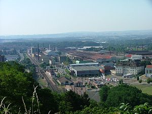
Le Creusot
Commune in Bourgogne-Franche-Comté, France
Distance: Approx. 244 meters
Latitude and longitude: 46.8014,4.4411
Le Creusot (pronounced [lə kʁøzo]) is a commune and industrial town in the Saône-et-Loire department, region of Bourgogne-Franche-Comté, eastern France. The inhabitants are known as Creusotins. Formerly a mining town, its economy is now dominated by metallurgical companies such as ArcelorMittal, Schneider Electric, and Alstom.
Parc des Combes
Amusement Park in Le Creusot
Distance: Approx. 2317 meters
Latitude and longitude: 46.8123,4.4117
Parc des Combes is an amusement park located in Le Creusot, in Burgundy, France. The wooded park is a part of the Les Chemins de Fer du Creusot ("Creusot Railways" in English) tourist attraction, served by the Train des Combes tourist train. The French word Combe can be translated as anticlinal valley, given that the park is located on an old Morvan valley.

Creusot steam hammer
Distance: Approx. 1731 meters
Latitude and longitude: 46.78664,4.432913
The Creusot steam hammer is a giant steam hammer built in 1877 by Schneider and Co. in the French industrial town of Le Creusot. With the ability to deliver a blow of up to 100 tons, the Creusot hammer was the most powerful in the world until 1891, when the Bethlehem Iron Company of the United States purchased patent rights from Schneider and built a steam hammer of almost identical design but capable of delivering a 125-ton blow.

Le Breuil, Saône-et-Loire
Commune in Bourgogne-Franche-Comté, France
Distance: Approx. 3553 meters
Latitude and longitude: 46.7953,4.4836
Le Breuil (French pronunciation: [lə bʁœj]) is a commune in the Saône-et-Loire department in the region of Bourgogne-Franche-Comté in eastern France.
Montcenis
Commune in Bourgogne-Franche-Comté, France
Distance: Approx. 3855 meters
Latitude and longitude: 46.7914,4.3897
Montcenis (French pronunciation: [mɔ̃səni]) is a commune in the Saône-et-Loire department in the region of Bourgogne-Franche-Comté in eastern France.

Torcy, Saône-et-Loire
Commune in Bourgogne-Franche-Comté, France
Distance: Approx. 1963 meters
Latitude and longitude: 46.7842,4.4364
Torcy (French pronunciation: [tɔʁsi] ) is a commune in the Saône-et-Loire department in the region of Bourgogne-Franche-Comté in eastern France.

Saint-Firmin, Saône-et-Loire
Commune in Bourgogne-Franche-Comté, France
Distance: Approx. 3963 meters
Latitude and longitude: 46.83,4.4697
Saint-Firmin (French pronunciation: [sɛ̃ fiʁmɛ̃] ) is a commune in the Saône-et-Loire department in the region of Bourgogne-Franche-Comté in eastern France.

Saint-Sernin-du-Bois
Commune in Bourgogne-Franche-Comté, France
Distance: Approx. 4349 meters
Latitude and longitude: 46.8408,4.4347
Saint-Sernin-du-Bois (French pronunciation: [sɛ̃ sɛʁnɛ̃ dy bwa]) is a commune in the Saône-et-Loire department in the region of Bourgogne-Franche-Comté in eastern France.
Communauté urbaine Creusot Montceau
Communauté urbaine in Bourgogne-Franche-Comté, France
Distance: Approx. 1096 meters
Latitude and longitude: 46.81,4.43
The Communauté urbaine Creusot Montceau is the communauté urbaine, an intercommunal structure, centred on the cities of Le Creusot and Montceau-les-Mines. It is located in the Saône-et-Loire department, in the Bourgogne-Franche-Comté region, eastern France. It was created in 1970.

Le Creusot TGV station
High-speed rail station in east-central France
Distance: Approx. 6221 meters
Latitude and longitude: 46.76527778,4.49972222
Le Creusot TGV (French: Gare du Creusot TGV, Le Creusot-Montceau-Montchanin officially) is a high-speed railway station on the LGV Sud-Est providing TGV services to the city of Le Creusot, Saône-et-Loire, France. It was inaugurated on 22 September 1981 by President François Mitterrand and opened to commercial service five days later. The station, located outside the city in the commune of Écuisses, is accessible by road.
Canton of Le Creusot-1
Distance: Approx. 1382 meters
Latitude and longitude: 46.8,4.42
The canton of Le Creusot-1 is an administrative division of the Saône-et-Loire department, eastern France. It was created at the French canton reorganisation which came into effect in March 2015. Its seat is in Le Creusot.
Canton of Le Creusot-2
Distance: Approx. 940 meters
Latitude and longitude: 46.8,4.45
The canton of Le Creusot-2 is an administrative division of the Saône-et-Loire department, eastern France. It was created at the French canton reorganisation which came into effect in March 2015. Its seat is in Le Creusot.
Weather in this IP's area
light rain
14 Celsius
14 Celsius
14 Celsius
14 Celsius
1003 hPa
97 %
1003 hPa
963 hPa
2801 meters
4.84 m/s
13.48 m/s
235 degree
100 %
07:50:32
19:08:35