Country:
 Switzerland
Region:
City:
Latitude and Longitude:
Time Zone:
Postal Code:
IP information under different IP Channel
ip-api
Country
Region
City
ASN
Time Zone
ISP
Blacklist
Proxy
Latitude
Longitude
Postal
Route
IPinfo
Country
Region
City
ASN
Time Zone
ISP
Blacklist
Proxy
Latitude
Longitude
Postal
Route
MaxMind
Country
Region
City
ASN
Time Zone
ISP
Blacklist
Proxy
Latitude
Longitude
Postal
Route
Luminati
Country
CHRegion
zh
City
zurich
ASN
Time Zone
Europe/Zurich
ISP
Init7 (Switzerland) Ltd.
Latitude
Longitude
Postal
db-ip
Country
Region
City
ASN
Time Zone
ISP
Blacklist
Proxy
Latitude
Longitude
Postal
Route
ipdata
Country
Region
City
ASN
Time Zone
ISP
Blacklist
Proxy
Latitude
Longitude
Postal
Route
Popular places and events near this IP address

A4 motorway (Switzerland)
Motorway in Switzerland
Distance: Approx. 1479 meters
Latitude and longitude: 47.415384,8.574615
The A4 motorway in Switzerland begins from Schaffhausen, in northern Switzerland, and travels southward into central Switzerland. The general route of A4 is: Bargen - Schaffhausen - Winterthur - Zürich - Central Switzerland.
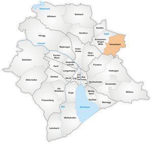
Hirzenbach
Distance: Approx. 955 meters
Latitude and longitude: 47.40462778,8.58730833
Hirzenbach is a quarter in the district 12 of Zürich, located in the Glatt Valley (German: Glattal). It was part of Schwamendingen municipality that was amalgamated into Zürich in 1934. The quarter has a population of 11,265 distributed on an area of 2.62 km2 (1.01 sq mi).

Saatlen
Distance: Approx. 1230 meters
Latitude and longitude: 47.41019167,8.56408056
Saatlen is a quarter in the district 12 of Zürich, located in the Glatt Valley (German: Glattal). It was formerly a part of Schwamendingen municipality, which was incorporated into Zürich in 1934. The quarter has a population of 6,727 distributed on an area of 1.13 km².

Schwamendingen
District in Zürich, Switzerland
Distance: Approx. 497 meters
Latitude and longitude: 47.406,8.572
Schwamendingen is a district in the Swiss city of Zürich. Formerly an independent community, it was incorporated into Zurich in 1934 to build district number 12. The district comprises the quarters Schwamendingen Mitte, Saatlen and Hirzenbach.

Schwamendingen Mitte
Distance: Approx. 562 meters
Latitude and longitude: 47.4042,8.58198056
Schwamendingen Mitte (Schwamendingen centre) is a quarter in the district 12 in Zürich, located in the Glatt Valley (German: Glattal). Schwamendingen and Oerlikon became independent municipalities in 1872. These were incorporated into the city of Zürich in 1934, together with Seebach, Affoltern, Witikon, Höngg, Altstetten and Albisrieden.

Glatt Valley
River Valley in Switzerland
Distance: Approx. 1744 meters
Latitude and longitude: 47.41666667,8.56666667
The Glatt Valley (German: Glattal or Glatttal) is a region and a river valley in the canton of Zürich in Switzerland.

Stettbach railway station
Railway station on the north-eastern boundary of the Swiss city of Zürich
Distance: Approx. 1667 meters
Latitude and longitude: 47.39722222,8.59611111
Stettbach railway station (German: Bahnhof Stettbach) is a railway station on the north-eastern boundary of the Swiss city of Zürich. Although the station is located just within the city boundary, in the city's Schwamendingen district, it takes its name from the nearby village of Stettbach, which is in the adjacent municipality of Dübendorf.

Wallisellen railway station
Swiss railway station
Distance: Approx. 1706 meters
Latitude and longitude: 47.412153,8.592296
Wallisellen is a railway station in Switzerland, in the municipality of Wallisellen. It is located on the Zurich to Winterthur railway line, and is to the Zurich side of the junction with the Wallisellen to Rapperswil via Uster line. The railway station is adjacent to the newly built Richti Shopping development.

Glattzentrum
Shopping mall in Wallisellen, Switzerland
Distance: Approx. 1679 meters
Latitude and longitude: 47.408901,8.59509
The Glattzentrum, more formally known as the Einkaufszentrum Glatt or Glatt shopping centre, is a shopping mall located in the Glatt Valley close to the Swiss city of Zurich. Politically, the mall is situated in the municipality of Wallisellen. The mall (size in square meters and number of shops unknown) was opened in 1975, being modeled on similar malls in the United States.
Richti Wallisellen
Mixed-use development in Wallisellen, Switzerland
Distance: Approx. 1679 meters
Latitude and longitude: 47.408901,8.59509
Richti Wallisellen is a mixed-use development (residential, commercial, offices) on former industrial land situated between Wallisellen railway station and the 1970s-era Glattzentrum indoor shopping mall. The master plan of the new complex was designed by architect Vittorio Magnago Lampugnani on a model of an Italian city center. Richti Wallisellen is made of six five-storey high buildings and one 72-meter-high glass high-rise.
International School Zurich North
School in Switzerland
Distance: Approx. 1621 meters
Latitude and longitude: 47.40956,8.59367
International School – Zurich North (ISZN) is a multi-cultural day school for students aged 3 to 18, located in the north-eastern suburbs of Zurich, Switzerland.The school community consists of over 200 students from approx.35 different countries. ISZN was acquired by Cognita on 21 June 2019. Grades 9 and 10 follow a 2-year programme leading to the International General Certificate of Secondary Education (IGCSE) by Cambridge International Examinations (CIE) and Grades 11 and 12 sit the A-Level Examinations from Pearson Edexcel or Cambridge International Examinations.
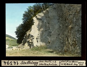
Staffelegg Formation
Formation of Early Jurassic age in the Canton of Aargau of northern Switzerland
Distance: Approx. 1883 meters
Latitude and longitude: 47.4,8.6
The Staffelegg Formation (German: Staffelegg-Formation, French: Formation de la Staffelegg, Italian: Formazione della Staffelegg) is a formation of Early Jurassic age (late Hettangian to early Toarcian stages) in the Canton of Aargau of northern Switzerland. The siltstones, marls, limestones and intermittent sandstones of the formation were deposited on the Northern Tethyan Carbonate Platform (NTCP). The Staffelegg Formation has provided fossils of the ichthyosaur Eurhinosaurus longirostris and the ammonite Catacoeloceras raquinianum.
Weather in this IP's area
moderate rain
20 Celsius
20 Celsius
19 Celsius
21 Celsius
1011 hPa
78 %
1011 hPa
961 hPa
10000 meters
1.54 m/s
130 degree
75 %
06:54:17
19:52:39