Country:
 Switzerland
Region:
City:
Latitude and Longitude:
Time Zone:
Postal Code:
IP information under different IP Channel
ip-api
Country
Region
City
ASN
Time Zone
ISP
Blacklist
Proxy
Latitude
Longitude
Postal
Route
IPinfo
Country
Region
City
ASN
Time Zone
ISP
Blacklist
Proxy
Latitude
Longitude
Postal
Route
MaxMind
Country
Region
City
ASN
Time Zone
ISP
Blacklist
Proxy
Latitude
Longitude
Postal
Route
Luminati
Country
CHRegion
zh
City
zurich
ASN
Time Zone
Europe/Zurich
ISP
Init7 (Switzerland) Ltd.
Latitude
Longitude
Postal
db-ip
Country
Region
City
ASN
Time Zone
ISP
Blacklist
Proxy
Latitude
Longitude
Postal
Route
ipdata
Country
Region
City
ASN
Time Zone
ISP
Blacklist
Proxy
Latitude
Longitude
Postal
Route
Popular places and events near this IP address
Zurich Altstetten railway station
Railway station in the Altstetten quarter of the Swiss city of Zürich
Distance: Approx. 999 meters
Latitude and longitude: 47.3915,8.489
Zürich Altstetten railway station (German: Bahnhof Zürich Altstetten) is a railway station in the Altstetten quarter of the Swiss city of Zürich. The station is located on the Zürich to Olten main line and is the junction for the Zürich to Zug via Affoltern am Albis line. The station is served by lines S5, S11, S12, S14, S19, and S42 of the Zürich S-Bahn.
F+F School for Art and Media Design Zurich
Art school in Zürich, Switzerland
Distance: Approx. 1965 meters
Latitude and longitude: 47.3818078,8.4900093
The F+F School for Art and Design Zürich or F+F is a private art school in Zürich, Switzerland. F+F stands for "Form und Farbe" (in German, "shape and color"), a discipline practiced at the German art and architecture school Bauhaus.
Avenir Suisse
Swiss think tank
Distance: Approx. 1991 meters
Latitude and longitude: 47.3893,8.5188
Avenir Suisse is a classical liberal think tank focused on Switzerland's future in political, economical and social areas. Its main goal is to stimulate the public debate and to provide new ideas through the publication of studies and the regular organisation of events and seminars. It encourages a liberal vision of the world and the society.
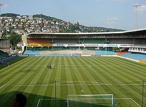
Hardturm
Football stadium in Zürich, Switzerland
Distance: Approx. 898 meters
Latitude and longitude: 47.39305556,8.50472222
The Hardturm was a football stadium located in Zürich's Kreis 5. Opened in 1929, it was the home of the Grasshopper Club Zürich until it closed in 2007. It was a host stadium for the 1954 FIFA World Cup.

Swiss Life Arena
Ice hockey arena in Zürich, Switzerland
Distance: Approx. 1302 meters
Latitude and longitude: 47.39536944,8.48003056
The Swiss Life Arena is an ice hockey and entertainment arena the Altstetten quarter of Zürich, Switzerland. It is located approximately seven kilometers west of downtown Zürich. The arena officially opened in October 2022.

Höngg
Distance: Approx. 291 meters
Latitude and longitude: 47.4,8.5
Höngg is a quarter in district 10 in Zürich. It was formerly a municipality of its own, having been incorporated into Zürich in 1934. The quarter has a population of 21,186, distributed across an area of 6.98 km2.
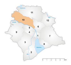
District 10 (Zürich)
District in Zurich, Switzerland
Distance: Approx. 939 meters
Latitude and longitude: 47.407,8.5
District 10 is a district in the Swiss city of Zurich. The district comprises the quarters Wipkingen and Höngg. Both entities were formerly municipalities of their own but were incorporated into Zurich in 1893 and 1934, respectively.

Käferberg
Summits of a wooded mountain
Distance: Approx. 1925 meters
Latitude and longitude: 47.40533,8.52021
Käferberg (el. 571 metres or 1,873 feet) and Waidberg (el. 601 metres or 1,972 feet) are the summits of a wooded range of hills overlooking the inner city of Zürich, Zürichsee, Albis chain and Uetliberg, as well as the Limmat Valley and the Zürcher Unterland in Switzerland.

Alte Kirche Höngg
Evangelical church building in Zurich, Switzerland
Distance: Approx. 295 meters
Latitude and longitude: 47.40153611,8.496925
The Alte Kirche Höngg (old church of Höngg) is a Reformed church in the district 10 of Zürich. Its congregation forms part of the Evangelical Reformed Church of the Canton of Zürich. Based on archeological research, the basement of the church relates to the 8/9th century.
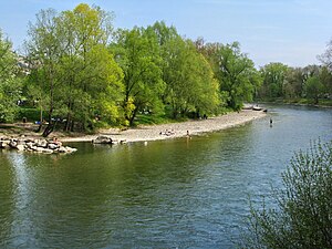
Werdinsel
Distance: Approx. 689 meters
Latitude and longitude: 47.4,8.4875
Werdinsel, also known as Limmatauen Werdhölzli, is an island and a protected area in the Limmat in Switzerland.
Liceo Vermigli
School in Zürich, Switzerland
Distance: Approx. 831 meters
Latitude and longitude: 47.39388889,8.48833333
Liceo linguistico e scientifico "Pier Martire Vermigli" (Italian pronunciation: [liˈtʃɛːo liŋˈɡwistiko e ʃʃenˈtiːfiko ˌpjɛr ˈmartire verˈmiʎʎi]) is a private Italian international liceo (upper secondary school) in Zürich, Switzerland. It is on the second and third floors of the "Casa d'Italia" facility, which also houses the Scuola statale primaria e dell'infanzia/Scuola Italiana di Zurigo, a primary school operated by the Italian government; and the Scuola media paritaria "Enrico Fermi", which is a private Italian lower secondary school. It was founded in 1978.
MuDA
Museum in Zurich, Switzerland
Distance: Approx. 1351 meters
Latitude and longitude: 47.3902,8.509
MuDA was the acronym of the Museum of Digital Art, an art space dedicated to digital arts. The institute was opened in February 2016 in Zurich by the non-profit Digital Arts Association. It closed by the end of June 2020.
Weather in this IP's area
broken clouds
10 Celsius
10 Celsius
9 Celsius
12 Celsius
1018 hPa
96 %
1018 hPa
968 hPa
10000 meters
0.65 m/s
0.63 m/s
186 degree
79 %
07:50:28
18:31:03