Country:
 Switzerland
Region:
City:
Latitude and Longitude:
Time Zone:
Postal Code:
IP information under different IP Channel
ip-api
Country
Region
City
ASN
Time Zone
ISP
Blacklist
Proxy
Latitude
Longitude
Postal
Route
IPinfo
Country
Region
City
ASN
Time Zone
ISP
Blacklist
Proxy
Latitude
Longitude
Postal
Route
MaxMind
Country
Region
City
ASN
Time Zone
ISP
Blacklist
Proxy
Latitude
Longitude
Postal
Route
Luminati
Country
CHRegion
bs
City
basel
ASN
Time Zone
Europe/Zurich
ISP
Init7 (Switzerland) Ltd.
Latitude
Longitude
Postal
db-ip
Country
Region
City
ASN
Time Zone
ISP
Blacklist
Proxy
Latitude
Longitude
Postal
Route
ipdata
Country
Region
City
ASN
Time Zone
ISP
Blacklist
Proxy
Latitude
Longitude
Postal
Route
Popular places and events near this IP address

Basel
City in Switzerland
Distance: Approx. 403 meters
Latitude and longitude: 47.55472222,7.59055556
Basel ( BAH-zəl; German: [ˈbaːzl̩] ), also known as Basle, is a city in northwestern Switzerland on the River Rhine (at the transition from the High to the Upper Rhine). Basel is Switzerland's third-most-populous city (after Zurich and Geneva), with 177,595 inhabitants within the city municipality limits. The official language of Basel is Swiss Standard German and the main spoken language is the local Basel German dialect.

Basel Massacre
Swiss 14th-century pogrom
Distance: Approx. 403 meters
Latitude and longitude: 47.55472222,7.59055556
The Basel Massacre was an anti-Semitic episode in Basel, which occurred in 1349 in connection with alleged well poisoning as part of the Black Death persecutions, carried out against the Jews in Europe at the time of the Black Death. A number of Jews, variously given as between 300 and 600 (according to contemporary Medieval chronicles) or 50 to 70 (according to some modern historians) were burned alive, after being locked in a wooden structure built on a nearby island in the Rhine. Jewish children were apparently spared, but forcibly baptized and sent to monasteries.
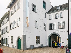
Museum of Cultures (Basel)
Distance: Approx. 215 meters
Latitude and longitude: 47.55722222,7.59083333
The Museum of Cultures in Basel (German: Museum der Kulturen Basel) is a Swiss museum of ethnography with large and important collections of artifacts, especially from Europe, the South Pacific, Mesoamerica, Tibet, and Bali. It is a Swiss heritage site of national significance.

Basel Minster
Church
Distance: Approx. 155 meters
Latitude and longitude: 47.55666667,7.59222222
Basel Minster (German: Basler Münster) is a religious building in the Swiss city of Basel, originally a Catholic cathedral and today a Reformed Protestant church. The original cathedral was built between 1019 and 1500 in Romanesque and Gothic styles. The late Romanesque building, destroyed by the 1356 Basel earthquake, was rebuilt by Johannes Gmünd, who was at the same time employed for building the Freiburg Münster.

Kunstmuseum Basel
Art museum in Basel, Switzerland
Distance: Approx. 396 meters
Latitude and longitude: 47.55416667,7.59416667
The Kunstmuseum Basel houses the oldest public art collection in the world and is generally considered to be the most important museum of art in Switzerland. It is listed as a Swiss heritage site of national significance. Its lineage extends back to the Amerbach Cabinet, which included a collection of works by Hans Holbein purchased by the city of Basel and the University of Basel in 1661, which made it the first municipally owned and therefore open to the public museum in the world.

Natural History Museum of Basel
Natural history museum in Basel, Switzerland
Distance: Approx. 230 meters
Latitude and longitude: 47.5575,7.59055556
Natural History Museum Basel (German: Naturhistorisches Museum Basel) is a natural history museum in Basel, Switzerland that houses wide-ranging collections focused on the fields of zoology, entomology, mineralogy, anthropology, osteology and paleontology. It has over 11 million objects. It was established as a natural history collection in 1821.

Antikenmuseum Basel und Sammlung Ludwig
Archaeological museum in Basel (Switzerland)
Distance: Approx. 371 meters
Latitude and longitude: 47.554379,7.593251
The Antikenmuseum Basel und Sammlung Ludwig (Basel Museum of Ancient Art and Ludwig Collection) is one of the many museums in the city of Basel, Switzerland and a heritage site of national significance. In 1961 the city of Basel decided to establish the museum to assemble the several antiquities in one place.

Basel-Münsterhügel
Distance: Approx. 227 meters
Latitude and longitude: 47.5557,7.593
Basel-Münsterhügel is the site of an Iron Age (late La Tène) fort or oppidum, known as Basel oppidum, constructed by the Gaulish Rauraci after the battle of Bibracte in 58 BC. It the site of Basel Minster, in the Swiss city of Basel. The fort was abandoned or destroyed shortly after its construction, before the end of the 1st century BC, with the Roman conquest of the Alps and the establishment of the province of Gallia Belgica. By the early 1st century AD, there was a small vicus on the hill built on top of the ruins of the oppidum, possibly the origin of the name Basilia, from a toponym villa Basilia "estate of Basilius".

The Blue and The White House
Distance: Approx. 320 meters
Latitude and longitude: 47.55833333,7.58944444
The Blue and The White House (Blaues und Weisses Haus) are two town mansions in the city of Basel. The semi-detached baroque mansions on the Rheinsprung 16 and 18 in Basel, also known as “The Reichensteinerhof” and “The Wendelstörferhof”, were built by the architect Samuel Werenfels for the brothers Lukas and Jakob Sarasin between 1763 and 1775. “The White House” belonged to Lukas (1730 – 1802) and “The Blue House” to his younger brother Jakob (1742 – 1802).
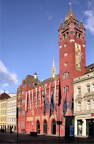
Basel Town Hall
Distance: Approx. 402 meters
Latitude and longitude: 47.55833333,7.58833333
The Basel Town Hall (German: Rathaus Basel, locally known as Roothuus) is a 500-year-old building dominating the Marktplatz in Basel, Switzerland. The Town Hall houses the meetings of the Cantonal Parliament as well as the Cantonal Government of the canton of Basel-Stadt. The Great Council Chamber at one time featured a series of frescoes painted in 1522 by Hans Holbein the Younger, which have been lost.
Evangelical Reformed Church of the Canton Basel-Landschaft
Distance: Approx. 199 meters
Latitude and longitude: 47.556,7.5928
The Evangelical-Reformed Church of the Canton Basel-Landschaft is a Reformed cantonal church in the canton of Basel-Landschaft, which does not include the eponymous city. In 2004 it had 113,537 members and 35 parishes and 65 ordained clergy. Member of the Schweizerischer Evangelischer Kirchenbund.

Middle Bridge, Basel
Bridge in Basel, Switzerland
Distance: Approx. 388 meters
Latitude and longitude: 47.56,7.58972222
The Middle Bridge (German: Mittlere Brücke [common name] / German: Mittlere Rheinbrücke [official name], French: Pont du Milieu) is a historic bridge in the Swiss city of Basel. It is situated on the oldest existing bridge site across the Rhine, between Lake Constance and the North Sea. It also marks the boundary between the High Rhine (Hochrhein) and Upper Rhine (Oberrhein/Rhin Supérieur) sections of the river.
Weather in this IP's area
few clouds
10 Celsius
10 Celsius
10 Celsius
13 Celsius
1018 hPa
96 %
1018 hPa
987 hPa
10000 meters
2.57 m/s
190 degree
20 %
07:54:20
18:34:25